Something beautiful to start the day with. Happy Thursday, everyone!
sltrib.com
The Internet at large has meticulously documented national park rock formations, sunsets and starscapes in the time-lapse video format.
Something beautiful to start the day with. Happy Thursday, everyone!
sltrib.com
The Internet at large has meticulously documented national park rock formations, sunsets and starscapes in the time-lapse video format.


Cathedral Valley Overlook, Capitol Reef National Park, Wayne County, Utah
Photographer: Gregg Beukelman; © 2015
Light-brown sandstone of the Jurassic-age Curtis Formation caps the underlying reddish siltstone of the Entrada Formation in Cathedral Valley. In places, only boulders remain of the resistant cap rock as the Curtis Formation slowly weathers away.


Geologic Map of The Donkey Flat Quadrangle, Uintah County, Utah
By: Paul H. Jensen, Douglas A. Sprinkel, Bart J. Kowallis, and Kent D. Brown
The Donkey Flat quadrangle is less than 10 miles north-northeast of Vernal, Utah, along the south flank of the Uinta Mountains in Uintah County. It includes Red Fleet State Park and is crossed by U.S. Highway 191 (a National Scenic Byway). The geology is well exposed and uncomplicated, making a dramatic landscape with thick sandstone cliffs and varicolored to drab gray slopes. The quadrangle’s namesake, Donkey Flat, is a one of several geomorphic surfaces mantled by piedmont gravel deposits.

Happy Groundhog Day, everyone! This photo feels as warm as Milltown Mel’s early spring prediction (compared to this morning in Salt Lake at least, brr!). What’s everyone hoping for?

Mount Timpanogos, Wasatch Range, Utah County, Utah
Photographer: Elizabeth Firmage; © 2015
Stewart Falls and the eastern slopes of Mount Timpanogos, Wasatch Range, Utah County.
geology.utah.gov
The Utah Geological Survey (UGS) has made the Utah Quaternary Fault and Fold Database available through a new interactive web application on the UGS website. This database contains information on faults and fault-related folds considered to be potential earthquake sources. The faults and folds in the database are considered to have been sources of large earthquakes (about magnitude 6.5 or greater) during the Quaternary geologic time period (past 2.6 million years); these geologic structures are the most likely sources of large earthquakes in the future. The Utah Quaternary Fault and Fold Database is the primary source of Utah data for the Quaternary Fault and Fold Database of the United States maintained by the U.S. Geological Survey (USGS).
The interactive map’s user interface was built using ESRI’s JavaScript API. Several search options allow the user to locate a fault of interest, or specify a location to see if any Quaternary faults are nearby. Pop-up windows provide a brief summary of important information associated with the faults, as well as a link to detailed reports available through the USGS national database. Users can select from a variety of basemaps including topographic, shaded relief, and satellite imagery. A glossary explains terms used in the pop-up windows as well as terms used in the detailed reports that may be unfamiliar to non-geologists.
In addition to the UGS interactive map, the Utah Quaternary Fault and Fold Database exists as a fully attributed GIS feature class in the State Geographic Information Database, and can be downloaded from the AGRC at http://gis.utah.gov/data/geoscience/quaternary-faults.


Boulder Mountain, Garfield County, Utah
Photographer: Elizabeth Firmage; © 2015
Aspen groves produce spectacular fall colors high on Boulder Mountain along the east side of the Aquarius Plateau. Large, rounded boulders eroded from Tertiary-age lava flows give Boulder Mountain its name.


Edited By: William R. Lund
This publication presents four investigations that provide new geologic and paleoseismic data on the Washington fault zone in southwestern Utah and northwestern Arizona. (1) New 1:24,000-scale geologic mapping shows the location and length of young surface ruptures and the relative ages of displaced surficial deposits along the fault zone. Based on the mapping, the former Northern section of the fault zone has been subdivided into the Fort Pearce and Washington Hollow sections. (2) A paleoseismic trenching investigation of a scarp on a latest Quaternary alluvial fan in Arizona that provides information on paleoearthquake timing, displacement, and recurrence for the Fort Pearce section, which traverses the St. George metropolitan area. (3) Trace element and major oxide geochemical correlation and radiometric dating of volcanic flows displaced across the fault that provide early to middle Quaternary vertical slip-rates for the Fort Pearce and Sullivan Draw sections of the fault.. (4) A geotechnical investigation that provides information on fault locations, paleoearthquakes, and displacement no the Fort Pearce section. These investigations show the Fort Pearce section of the Washington fault zone has experienced at least two surface-faulting earthquakes in the Holocene and a minimum of five earthquakes in the past ~68 ka.

Another beautiful morning on the Wasatch Front with another weekend on the way. Big Cottonwood Canyon is looking a little more wintry these days!

Big Cottonwood Canyon, Wasatch Range, Salt Lake County, Utah
Photographer: Paul Inkenbrandt; © 2015
Utah’s Upheaval Dome has been the subject of theories surrounding its existence for decades. This article outlines one theory in particular. Check it out!
atlasobscura.com
For decades, two theories about the formation of Utah’s Upheaval Dome jostled for supremacy.
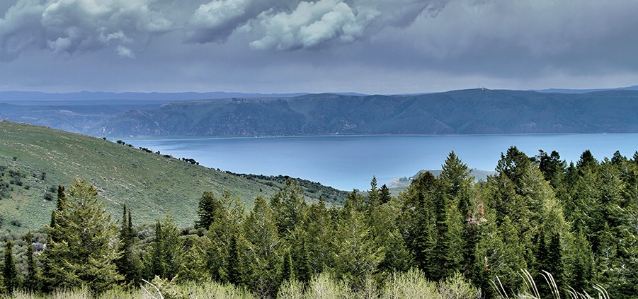
Another Tuesday winds down. Enjoy this view of Bear Lake in your outdoor daydream for the day….just don’t let the Bear Lake Monster bite!
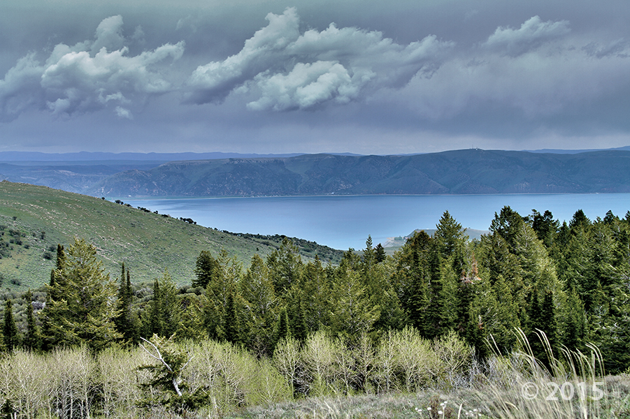
Bear Lake, Rich County, Utah
Photographer: Nikki Simon; © 2015
While it is one of the oldest lakes in North America, Bear Lake is best known for its blue splendor. The water in Bear Lake is pristine, deep, and calcium-carbonate rich, giving it a blue appearance.
![]()
The Utah Geological Survey (UGS) is a division of the Utah Department of Natural Resources. Several specialized programs comprise the UGS: Data Management, Energy & Minerals, Geologic Hazards, Geologic Information & Outreach, Geologic Mapping, Groundwater & Wetlands, and Paleontology.