
Wetlands in Utah
Though Utah is one of the driest states in the nation with a cold desert climate, wetlands are found throughout the state. Great Salt Lake has the highest concentration of wetlands found anywhere in Utah, with hundreds of thousands of acres of playas, marshes, meadows, and duck ponds found along the shores of the lake. The great diversity of wetland types located close to one another helps the Great Salt Lake ecosystem support millions of migrating and nesting birds each year. Other wetlands throughout Utah are also very important in providing critical habitat, unique recreation and aesthetic opportunities, and water sources in our arid state.


Wetlands in Utah are incredibly varied, ranging from small, isolated spring complexes in the West Desert to cottonwood and willow stands stretching for miles along some of Utah’s larger rivers like the Colorado or Green. Other unique wetlands in Utah include the hanging gardens of the Colorado Plateau like the Weeping Rock of Zion National Park, montane fens and wet meadows like Christmas Meadows in the Uinta National Forest, and large, unvegetated, highly saline playas in desert basins such as Sevier Lake and the Bonneville Salt Flats.

Montane wet meadow in the Uinta Mountains. Waterlogged soils in wet meadows prevent the growth of pine and spruce trees and create a forest opening. Sedges, rushes, and grasses that are more tolerant of these waterlogged soils can establish in these openings and form the scenic wet meadows dotting the Uinta Mountains.
Wetland Types
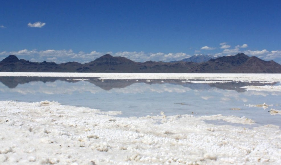
The Bonneville Salt Flats—one of Utah’s largest wetlands. Wetland hydrology in the salt flats is supported by a shallow, highly saline aquifer and accumulated precipitation. This precipitation helps recharge the shallow aquifer but also creates an iconic reflected landscape.
The landform, hydrologic, and land-use history processes that form and shape wetlands are unique to each wetland and no two wetlands are alike. Many wetlands, however, share broad similarities in vegetation, landscape position, water source, and flooding frequency and duration, allowing for wetlands to be grouped into broad types. Grouping into types makes it easier to visualize a particular wetland and provides information about the plant communities, water availability, and functions or services that are likely present at that wetland. Swamps, playas, springs, fens, wet meadows, and willow thickets are everyday terms used to identify various wetland types that imply different plant communities, amounts of water, or locations in relation to other landscape features. Knowing this sort of information is essential for restoration projects, management programs, or conditional assessments.
Because one person’s swamp could be another’s marsh, there are several classification systems with standardized methods of grouping wetlands into consistent wetland types. Some systems like the Cowardin system used by the National Wetland Inventory focus on vegetation characteristics, while other systems like the hydrogeomorphic (HGM) system used by the U.S. Army Corps of Engineers focus on a wetland’s landscape position and surrounding landforms. Each classification system has particular strengths, drawbacks, and applications for which it is best suited.
Regardless of how Utah’s wetlands are classified, wetlands are rare features in the state. Vegetated wetlands like wet meadows or marshes account for roughly 1% of Utah’s total land cover and waterbodies such as lakes, ponds, or flowing rivers account for another 2-3% of Utah’s total land cover, with Great Salt Lake and Utah Lake composing much of that cover. Unvegetated features, less commonly thought of as wetlands, are actually the most common wetlands in Utah. Features like playas, dry washes, and shorelines account for roughly 5-8% of Utah’s land cover, largely due to two playas, Bonneville Salt Flats and Sevier Lake, and the exposed shoreline of Great Salt Lake.
% Land Cover by Aquatic Resource Type


* National Land Cover Dataset, updated in 2016. NLCD data for barren features includes non-wetland areas such as talus and snow and percent cover might be artificially high.
** National Wetland Inventory, updated in 2019. NWI Riverine wetland cover includes dry washes as well as perennial and seasonal streams.
Wetlands Near You
Many of Utah’s unique wetlands are located on public land and easily accessed via boardwalks, paved trails, and hiking paths. Viewing some of Utah’s wetlands can even be as simple as travelling along Interstate 80 through the Bonneville Salt Flats. Many wildlife management areas and nature centers feature wetlands in their educational and interpretive programs and offer an excellent opportunity to learn more about the interesting plants, wildlife, and history of wetlands in Utah. Visiting a wetland can be a great outing to see beautiful scenery, enjoy the outdoors, and experience some of Utah’s rarest landscapes.
Find publicly accessible wetlands near you by searching keywords (cities, counties, activities, etc.) and expanding the rows for more information.
Wetlands Mapping
The first step in effective wetland conservation and management is understanding the distribution and extent of wetlands throughout the state, which requires spatial datasets of mapped wetlands. Several datasets display mapped wetlands across Utah, with the National Wetland Inventory (NWI) being the most comprehensive and commonly used. However, much of the NWI mapping in Utah was completed from imagery taken during the 1980s and doesn’t accurately capture recent development or advances in mapping technology. The Utah Geological Survey is part of an ongoing effort to develop a comprehensive, modern wetland dataset for the state. The UGS actively updates the NWI mapping across Utah and has completed mapping projects around Great Salt Lake, Jordan River, Bear Lake and the upper Bear River basins, and parts of the Uinta Basin. Updated wetland mapping is available to download and view at several locations such as the UGRC and the NWI Wetlands mapper.

