GEOLOGIC HAZARDS

Earthquake Hazards

Utah has experienced 17 earthquakes greater than magnitude (M) 5.5 since pioneer settlement in 1847, and geologic investigations of our region’s faults indicate a long history of repeated large earthquakes of M 6.5 and greater prior to settlement. Seismic activity can often trigger a succession of additional potentially destructive hazards. The seismic-related hazards listed below all possess their own potential for destruction. Some areas of the state are more susceptible than others when it comes to being at risk.

While Utah is not on a boundary between tectonic plates where most of the world’s earthquakes occur, it is in the tectonically extending western part of the North American plate. Thus, earthquakes in Utah are related to interactions with the Pacific plate along the plate margin on the west coast of the United States. Also, many small earthquakes in east-central Utah are induced by underground coal mining.

Utah Earthquakes Virtual Field Trip from the Natural History Museum of Utah.
View all their virtual field trips here.

Visit earthquakes.utah.gov for Utah-specific preparedness information and the latest earthquake news.

Ground Shaking

A sudden motion or trembling of the earth as stored elastic energy is released by fractures and movement of rocks along a fault.

Surface Fault Rupture

Displacement (rupture) of the ground surface along a tectonic fault during an earthquake that often results in a a steep scarp.
Learn More.

Liquefaction

A sudden, large decrease in shear strength of a saturated sandy soil caused by a temporary increase in soil pore water pressure during an earthquake.
Learn More.

Landslides and Rockfalls

Landslides and/or rockfalls can be triggered by earthquake ground shaking.
Learn More.

Tsunamis

A series of waves in the ocean or lake caused by the displacement of a large volume of water. Displacement may be due to underwater fault rupture or landslides into the water.

Seiches

A standing (oscillating) wave in a body of water that is at least partially enclosed and can be induced by earthquakes and other energy sources.

Tectonic Subsidence

The lowering and tilting of a valley floor on the down-dropped side of a fault during an earthquake. This commonly causes localized flooding and gravity flow utility failure.

Quick Clays

Typically marine-type clays that significantly lose strength when subjected to sufficient stress.

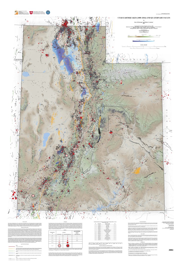
Utah Earthquakes (1850 to 2016) and Quaternary Faults Map

This map shows earthquakes known to have occurred within and surrounding Utah from 1850 through December 2016 and mapped Quaternary faults considered to be earthquake sources. The faults shown on the map have been sources of large earthquakes (about magnitude 6.5 or greater) during the Quaternary Period (past 2.6 million years) and are the most likely sources of large earthquakes in the future. Most small to moderate size earthquakes plotted on the map are “background” earthquakes not readily associated with known faults and of a size generally below the threshold of surface faulting (about magnitude 6.5). Buried or unmapped secondary faults are likely sources of much of the background seismicity.

Visit the Utah Geologic Hazards Portal

Home damaged by the Springdale landslide caused by the 1992 St. George earthquake.

Costs of Earthquake Hazards

Although only two fatalities (ground shaking-related) from earthquakes have occurred in Utah since 1847, scenario modeling predicts 2000 to 2500 fatalities, 7400 to 9300 life-threatening injuries, 55,400 buildings completely damaged, 21 million tons of debris, and $33.2 billion in estimated short-term, direct economic losses from a major M 7.0 earthquake on the Salt Lake City segment of the Wasatch fault zone. Short-term financial losses and long-term economic costs include damages, cleanup, closed businesses, lower productivity and economic output, and other costs. It is projected that 61% of the total number of buildings in the 12 county area in northern Utah will be moderately damaged or totally destroyed. Such an event will likely take decades to recover from and will be the single most costly geologic hazard event to affect Utah.

Related Information:
Geologic Hazards and Insurance – Are You Covered?

Paleoseismology of Utah Series

Highlighted Scientific Publications

Circular 122

Guidelines for Investigating Geologic Hazards and Preparing Engineering-Geology Reports, with a Suggested Approach to Geologic-Hazard Ordinances in Utah

Open File Report 667

Earthquake Database for Utah Geological Survey Map 277—Utah Earthquakes (1850–2016) and Quaternary Faults

Special Study 163

Surface Fault Rupture Map - Geologic Hazards of the Tickville Spring Quadrangle, Salt Lake and Utah Counties, Utah

Public Interest Articles

Search
TitleTopicYear
Digging Up Evidence of Past Earthquakes in Salt Lake Valley Earthquakes 2023
Mapping Geologic Hazards in and Near Bryce Canyon National Park Hazard Mapping 2023
Putting Down Roots in Utah’s Earthquake Country Second Edition Provides Updated and New Information Earthquakes 2022
Putting Down Roots in Earthquake Country – Your Handbook for Earthquakes in Utah Earthquakes 2022
The UGS Response to the March 18, 2020, Magnitude 5.7 Magna, Utah, Earthquake and Aftershock Sequence Earthquakes 2020
Investigating Earthquake Hazard on the Southern Wasatch Fault Zone Earthquakes 2019
What is an unconformity? Geologic History 2018
Geologic Hazard Mapping In Glen Canyon National Recreation Area Hazards 2017
The Wasatch Fault from Above: Re-mapping the Wasatch Fault Zone Using Airborne High-Resolution Topographic Data Faults 2017
Smoky Mountain, Kane County Mountains 2016
Liquefaction Hazards in Utah Hazards 2016
What geologic hazards should I be aware of as a homeowner in Utah? Hazards 2016
Paleoseismic Investigation of the Taylorsville Fault, West Valley Fault Zone, Utah Faults 2016
Recent Urban Geologic Mapping of Northwestern Salt Lake Valley Mapping 2016
Update on the Markagunt gravity slide: Utah’s largest landslide just got bigger – a lot bigger Geologic History 2016
What is an Earthquake Early Warning System, and does Utah Have One? Earthquakes 2015
The Early Miocene Markagunt Megabreccia: Utah’s Largest Catastrophic Landslide Geologic History 2013
Evaluating the seismic relation between the West Valley fault zone and Salt Lake City segment of the Wasatch fault zone Hazards 2012
Liquefaction in the April 15, 2010, M 4.5 Randolph Earthquake Hazards 2011
Land Subsidence and Earth Fissures in Cedar Valley Hazards 2011
UGS Responds to the Magnitude 6.0 Wells, Nevada, Earthquake Earthquakes 2008
UGS Excavates New Fault Trenches on the Weber Segment of the Wasatch Fault Zone Faults 2008
Wasatch Fault: End Segments Hazards 2007
I am thinking of buying a house at “X” address… is it near a fault? Faults 2007
Wasatch Fault: Nephi Segment Hazards 2007
Earthquakes – Wasatch Fault Earthquakes 2007
Protecting Utah Homes Hazards 2005
Earth Fissures in Escalante Hazards 2005
Earth Fissures near Beryl Junction in the Escalante Desert Earth Fissures 2005
Improving Our Understanding of Earthquake Hazards in Utah Hazards 2004
Earthquake Fault Map of a Portion of Tooele County, Utah Maps 2004
Earthquake Fault Map of a Portion of Washington County, Utah Maps 2004
The Mapleton Megatrench Hazards 2004
New Guidelines for Evaluating Surface- Fault-Rupture Hazards in Utah Hazards 2004
What are seismic surveys and how much “shaking” do they create? Earthquakes 2004
Maps Show Potential Geologic Effects of a Magnitude 7 Earthquake Hazards 2003
Triggered Seismicity in Utah from the Denali Fault Earthquake Hazards 2003
Ground-Shaking Map for a Magnitude 7.0 Earthquake on the Wasatch Fault Salt Lake City, Utah Metropolitan Area Hazards 2002
Photo essay of four Utah earthquakes, 1921-1972 (pdf) Earthquakes 2001
Utah’s Sevier Thrust System Geologic History 2000
What is the Grand Staircase? (pdf) Landforms 1999
Earthquakes & Utah (pdf) Earthquakes 1997
The Wasatch Fault (pdf) Earthquakes 1996
Homebuyers guide to earthquake hazards in Utah (pdf) Earthquakes 1996
Earthquake Ground Shaking in Utah Hazards 1994
Earthquake Fault Map of a Portion of Utah County, Utah Maps 1991
Earthquake Fault Map of a Portion of Salt Lake County, Utah Maps 1990
Earthquake Fault map of a Portion of Weber County, Utah Maps 1990
Earthquake hazards and safety in Utah (pdf) Earthquakes 1990
Earthquake Fault Map of a Portion of Davis County, Utah Maps 1989

Earthquake Articles: 52

External Links

The Great Shakeout Annual Exercise

Millions of people worldwide practice how to “Drop, Cover, and Hold On” each year during Great ShakeOut Earthquake Drills to be prepared to survive and recover quickly from big earthquakes.


Utah Division of Emergency Management

DEM plays an active role during emergencies and disasters. The Division coordinates emergency management efforts among State agencies, in collaboration with federal and local government. These efforts include preparedness, response, recovery and mitigation.


Utah Seismic Safety Commission

The Utah Seismic Safety Commission provides expertise and staff to the 15-member volunteer state commission that works toward reducing Utah’s earthquake hazards and managing Utah’s earthquake risk.