Mapping Geologic Hazards in and Near Bryce Canyon National Park
by Tyler Knudsen

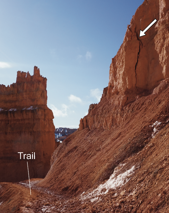
Periodic slope monitoring can detect signs of imminent slope failure such as this detached block of Claron Formation (noted with a white arrow) above the Navajo Loop Trail.
Known for its colorful and intricately eroded landscape, Bryce Canyon National Park (BCNP) has attracted several millions of visitors since its establishment as a National Monument in 1923. From the 1990s through the mid-2000s, BCNP averaged about 1 million visitors annually. Visitation has more than doubled over the past two decades, peaking at nearly 2.7 million visitors in 2018. Geologic processes that shaped BCNP’s dramatic landscape are still active today and can be hazardous to visitors, park employees, and infrastructure. To help reduce negative impacts from geologic hazards, the Utah Geological Survey (UGS), with support from the Bryce Canyon Natural History Association and the National Park Service (NPS), conducted a geologic-hazard investigation of a 270 square-mile area centered on the park. The study area encompasses BCNP, the communities of Tropic and Bryce Canyon City, and recreational areas within the adjoining Dixie National Forest and Grand Staircase–Escalante National Monument. Available geologic, hydrologic, topographic, soil, and geotechnical information was used to identify the location and severity of mapped geologic hazards that may impact safety and existing and future development. Early recognition and mitigation of geologic hazards can reduce risk to life, property, and the local economy. Our study provides descriptions and maps for 14 geologic hazards: rockfall, landslides, flooding/debris flow, shallow groundwater, surface faulting, liquefaction, collapsible soil, piping and erosion, wind-blown sand, soluble rock, corrosive soil and rock, expansive soil and rock, shallow bedrock, and radon gas.
BCNP is centered on the eastern rim of the Paunsaugunt Plateau that is part of the High Plateaus subsection of the Colorado Plateau province. The eastern plateau rim marks a major drainage divide that separates the relatively low-gradient Sevier River system and the much steeper Paria River system that is a tributary to the Colorado River. The Paria River’s steeper gradient induces greater erosional downcutting than the gentle Sevier River system. Much of BCNP, including its high-use areas, is dominated by the iconic, brightly colored limestone, sandstone, mudstone, and conglomerate of the Paleocene to Eocene (about 65 to 35 million years ago) Claron Formation. On the surface of the Paunsaugunt Plateau that is drained by the Sevier River system, Claron strata typically weather to gently rolling hollows and hills. However, along the plateau’s eastern rim aggressive erosion by the Paria River system into the Claron Formation has sculpted steep-walled amphitheaters adorned with vertical spires, hoodoos, and slot canyons—collectively known as the Pink Cliffs. Mass wasting (rockfalls, landslides, and debris flows) and flash floods along the Pink Cliffs create the principal geologic hazards with which visitors, park employees, planners, and public safety personnel must contend.
Rockfall hazard is particularly acute along BCNP’s increasingly popular Under-the-Rim Trails that descend into and traverse the actively eroding Pink Cliffs. The sharp increase in park visitation over the past decade has further increased the likelihood of a hazardous rockfall-visitor encounter. Since 2010, the NPS routinely closes Wall Street—part of the Under-the-Rim Trail network that passes through a photogenic and precarious vertical-walled canyon—in winter months when increased moisture and freezing temperatures combine (frost wedging) to produce frequent rockfalls. Starting in 2016, the NPS began using on-trail Preventative Search and Rescue (PSAR) volunteers to alert visitors to risks that may be encountered while hiking the Under-the-Rim Trails. These volunteers can instruct hikers to reduce their risk to rockfall by limiting their time spent in extremely high-hazard sections of trail, such as Wall Street. Weather-triggered closures, PSAR volunteers, informational signage, and periodic slope monitoring that can detect signs of failure are the most effective tools the NPS can use to improve visitor safety in this vulnerable area.

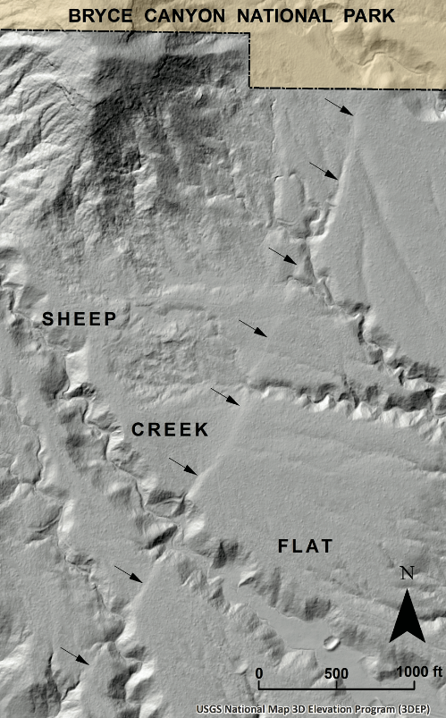
The Paunsaugunt fault (indicated by arrows) has vertically displaced the surface of Sheep Creek Flat up to 6 feet.
Although large earthquakes are rare in the Bryce Canyon area, strong ground shaking, surface faulting, and liquefaction are still possible. Potential sources of strong earthquakes near BCNP include the Sevier fault, 12 miles to the west, and the Paunsaugunt fault that traverses directly through the study area. Currently, most of the Paunsaugunt fault in Utah, including all fault sections in the study area, is not included in the UGS database of hazardous faults (faults that have ruptured the ground surface within the Quaternary time period or the past 2.6 million years). However, mapping completed for this study shows that Quaternary-age deposits are locally displaced by the Paunsaugunt fault in the Bryce Canyon area and that the fault should be considered hazardous. Results from this study will be used to improve the UGS hazardous fault database.
Most of the remaining geologic hazards considered in this study are localized, and though potentially costly when not recognized and properly mitigated, the problems associated with them are rarely life threatening. Upon publication later this year, this geologic-hazards investigation and mapping will be available for viewing and download from the UGS Geologic Hazards Portal.
ABOUT THE AUTHOR
Tyler Knudsen
is a Senior Geologist in the UGS Geologic Hazards Program where he has worked since 2006. Based out of the Cedar City office, he has authored or co-authored several maps and studies on the geology and geologic hazards of southwest Utah. Tyler holds degrees from the University of Utah (2002, B.S. geology) and the University of Nevada, Las Vegas (2005, M.S. geoscience), and is a Utah licensed Professional Geologist.


 Riparian wetlands of Moab's Mill Creek, where invasive species removal and cattle fencing has allowed native willows to grow again.


