GEOLOGIC HAZARDS

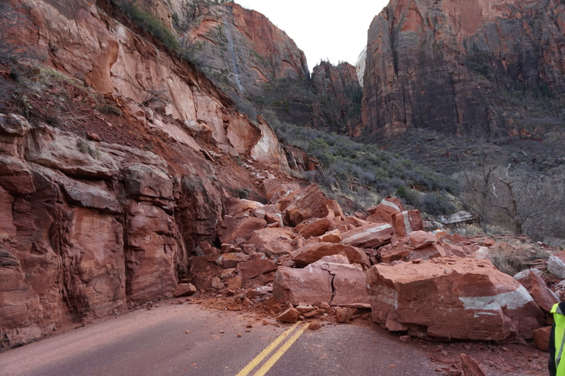
Scenic Drive Rockfall Reconnaissance, Zion National Park, Utah.

Geologic Hazards

Geologic hazards are geologic conditions that may cause substantial loss or damage to property, damage to the environment and economy, health risks, injury, or even death. While many geologic hazards are not life-threatening, many are often costly when not recognized and properly accommodated for with land-use management and project planning and design. Failure to accommodate geologic hazards may result in additional, significant construction and/or future maintenance costs, economic losses, and injury or death.

Since 1850, at least 6,075 deaths and an undetermined financial cost have been attributed to geologic hazards in Utah.

Damages caused by geologic hazards are often not covered by property or other insurance. In almost all cases, it is more cost effective to investigate and characterize potential hazards and implement appropriate mitigation, rather than rely on additional maintenance over the life of a project and/or incur costly construction change orders and other financial costs. We can live and deal with geologic hazards by understanding what they are, where they exist, how large or difficult they are, and how to effectively mitigate them.

To ensure that future development within Utah is protected from geologic hazards, the UGS recommends that a comprehensive engineering-geology and geotechnical engineering investigation be performed by licensed professionals for all development. Such investigations provide valuable information on site geologic conditions that may affect or be affected by development, as well as the type and severity of geologic hazards at a site and recommend solutions to mitigate the effects and the costs of the hazards, both at the time of construction and over the life of the development.

Learn More About Geologic Hazards in Utah

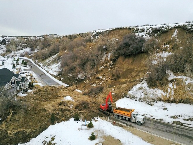
Geologic hazards that affect Utah include earthquakes, landslides, flooding, problem soils and rocks, and volcanic hazards.

Hazard Resources


Hazard Assistance

Services, assistance, and emergency response provided by the UGS.

The Bear Hollow Lakes landslide near Riverside that nearly impacted a house (at left of photo) in the private Bear Hollow Lakes development. A concrete block barrier was subsequently placed along the road in an attempt to protect the house. Previous historical landslides are evident in the river bluff above and on both sides of this recent landslide. Photo taken February 19, 2017, courtesy of Pete Clark.

Information and Maps

Reports, maps, and other information about geologic hazards in Utah.

Highlighted Scientific Publications

Open File Report 667

Earthquake Database for Utah Geological Survey Map 277: Utah Earthquakes (1850-2016) and Quaternary Faults

Special Study 159

Paleoseismology of Utah, v. 28 – Holocene Surface-Faulting Earthquakes at the Spring Lake and North Creek Sites on the Nephi Segment of the Wasatch Fault Zone: Evidence for Complex Rupture of the Nephi Segment

Special Study 163

Geologic Hazards of the Tickville Spring Quadrangle, Salt Lake and Utah Counties, Utah

Map 277

Utah Earthquakes (1850-2016) and Quaternary Faults


Public Interest Articles

Search
TitleTopicYear
Hazard News: An Update on Utah’s Very Active Spring 2023 Landslide Season Landslides 2023
Springhill Geologic Park, Davis County, Utah Landslides 2023
What do landslides, glaciers, and faults have to do with the lakes on the Wasatch Plateau? Lakes and Hazards 2023
Digging Up Evidence of Past Earthquakes in Salt Lake Valley Earthquakes 2023
Mapping Geologic Hazards in and Near Bryce Canyon National Park Hazard Mapping 2023
Putting Down Roots in Earthquake Country – Your Handbook for Earthquakes in Utah Earthquakes 2022
Putting Down Roots in Utah’s Earthquake Country Second Edition Provides Updated and New Information Earthquakes 2022
The New Utah Aerial Imagery Database: A Statewide Resource of Historical Aerial and Related Imagery Aerial Imagery 2022
Incorporating Small Unmanned Aircraft System (sUAS) Technology in Geologic Hazard Characterization and Emergency Response: Zion National Park Geologic Hazards 2022
The UGS Response to the March 18, 2020, Magnitude 5.7 Magna, Utah, Earthquake and Aftershock Sequence Earthquakes 2020
Needing a Great Resource for Teaching Your Students About Utah Fossils? Technology 2020
Drones for Good: Utah Geologists Take to the Skies Technology 2019
Investigating Earthquake Hazard on the Southern Wasatch Fault Zone Earthquakes 2019
The Curious Spring Creek Road Landslide Landslides 2019
The Wasatch Fault from Above: Re-mapping the Wasatch Fault Zone Using Airborne High-Resolution Topographic Data Faults 2017
2017 Flooding And Landslides In Box Elder County, Utah Hazards 2017
Update on the Markagunt gravity slide: Utah’s largest landslide just got bigger – a lot bigger Geologic History 2016
Paleoseismic Investigation of the Taylorsville Fault, West Valley Fault Zone, Utah Faults 2016
What geologic hazards should I be aware of as a homeowner in Utah? Hazards 2016
UGS Updates Existing and Develops New Guidelines for Investigating Geologic Hazards Hazards 2016
Liquefaction Hazards in Utah Hazards 2016
What is an Earthquake Early Warning System, and does Utah Have One? Earthquakes 2015
LiDAR—Valuable Tool in the Field Geologist’s Toolbox Maps 2015
Emergency Response and the Utah Geological Survey, What role do we serve and what services are provided? Hazards 2015
The Early Miocene Markagunt Megabreccia: Utah’s Largest Catastrophic Landslide Geologic History 2013
New Geologic Data Resources for Utah Maps 2013
Rock Fall: An Increasing Hazard in Urbanizing Southwestern Utah Hazards 2013
Damaging Debris Flows Prompt Landslide Inventory Mapping for the 2012 Seely Fire, Carbon and Emery Counties, Utah Hazards 2013
Can rockfalls cause wildfires? Hazards 2013
2011 Landslides in Utah Hazards 2012
Another large landslide closes highway near Cedar City, Utah Hazards 2012
Evaluating the seismic relation between the West Valley fault zone and Salt Lake City segment of the Wasatch fault zone Hazards 2012
Liquefaction in the April 15, 2010, M 4.5 Randolph Earthquake Hazards 2011
Updated Landslide Maps of Utah Maps 2011
Land Subsidence and Earth Fissures in Cedar Valley Hazards 2011
Landslide Hazards in Utah Hazards 2011
Ancient Landslides of the Beaver Dam Mountains, Washington County, Utah Geologic History 2009
Wall Arch, a Fallen Giant, Grand County Arches 2009
Logan Landslide Hazards 2009
Large Rock Fall Closes Highway Near Cedar City, Utah Hazards 2009
Second Damaging Y Mountain Rock Fall in Four Years Hazards 2009
Landslide Inventory Mapping in Twelvemile Canyon, Central Utah Hazards 2009
New Geologic Hazards Mapping in Utah Maps 2009
Rock-Fall Hazards in Utah Hazards 2009
UGS Responds to the Magnitude 6.0 Wells, Nevada, Earthquake Earthquakes 2008
Geologic-Hazard and Adverse-Construction-Condition Maps for the St. George–Hurricane Area, Washington County, Utah Maps 2008
UGS Compiles GIS Database Showing Geologic-Hazard Special-Study Areas for the Wasatch Front Hazards 2008
The Green Pond Landslide, Imperceptibly Moving Ground Hazards 2008
UGS Excavates New Fault Trenches on the Weber Segment of the Wasatch Fault Zone Faults 2008
Earthquakes – Wasatch Fault Earthquakes 2007

Hazard Articles: 108