Great Salt Lake & Lake Bonneville
Today’s Great Salt Lake is a shallow, salty remnant of ancient Lake Bonneville. The Lake occupies the lowest part of the Bonneville basin located in the Great Basin hydrological province. The size, shape, and location of this basin is controlled by tectonics, in particular the faulting and stretching of Earth’s crust that has created a pattern of mountains and valleys that define the Basin and Range physiographic province. Other relics of Lake Bonneville are Utah Lake, Sevier Lake, and the Great Salt Lake Desert which contains the famous Bonneville Salt Flats. Much of the salt now contained in Great Salt Lake was originally in the water of Lake Bonneville. Even though Lake Bonneville was freshwater, it contained salts that concentrated as its water evaporated and the lake contracted. About two million tons of dissolved salts, leached from the soil and rock in the Bonneville basin, is deposited in Great Salt Lake every year by rivers that flow into the lake.
Great Salt Lake Basics
Great Salt Lake is a terminal lake because it has no surface outlet (rivers flowing from it). Water is lost from the lake mostly through evaporation. Evaporation rates are highest during the hot summer months and lowest during the winter. An average of about 3 million acre-feet of water evaporates from the lake each year.
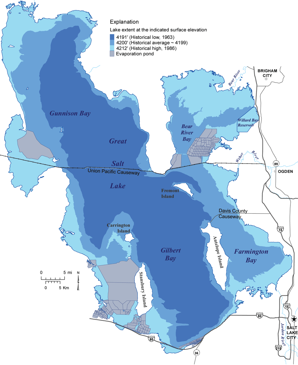
Great Salt Lake averages approximately 75 miles long by 35 miles wide at a water surface elevation of about 4,200 feet. At this elevation, the lake covers an area of 1,034,000 acres, and has a maximum depth of about 33 feet. Typically, the lake level fluctuates one to two feet annually, rising to its highest level during May through July (following the melting of the mountain snowpack) and dropping to its lowest point during October through November (after the hot summer months).
Image Caption: Great Salt Lake water levels have varied by more than 20 feet in historical time, resulting in shoreline shifts of as much as 20 miles.
Great Salt Lake Basics
 Great Salt Lake is a terminal lake because it has no surface outlet (rivers flowing from it). Water is lost from the lake mostly through evaporation. Evaporation rates are highest during the hot summer months and lowest during the winter. An average of about 3 million acre-feet of water evaporates from the lake each year.
Great Salt Lake averages approximately 75 miles long by 35 miles wide at a water surface elevation of about 4,200 feet. At this elevation, the lake covers an area of 1,034,000 acres, and has a maximum depth of about 33 feet. Typically, the lake level fluctuates one to two feet annually, rising to its highest level during May through July (following the melting of the mountain snowpack) and dropping to its lowest point during October through November (after the hot summer months).
Image Caption: Great Salt Lake water levels have varied by more than 20 feet in historical time, resulting in shoreline shifts of as much as 20 miles.
Lake Bonneville Basics
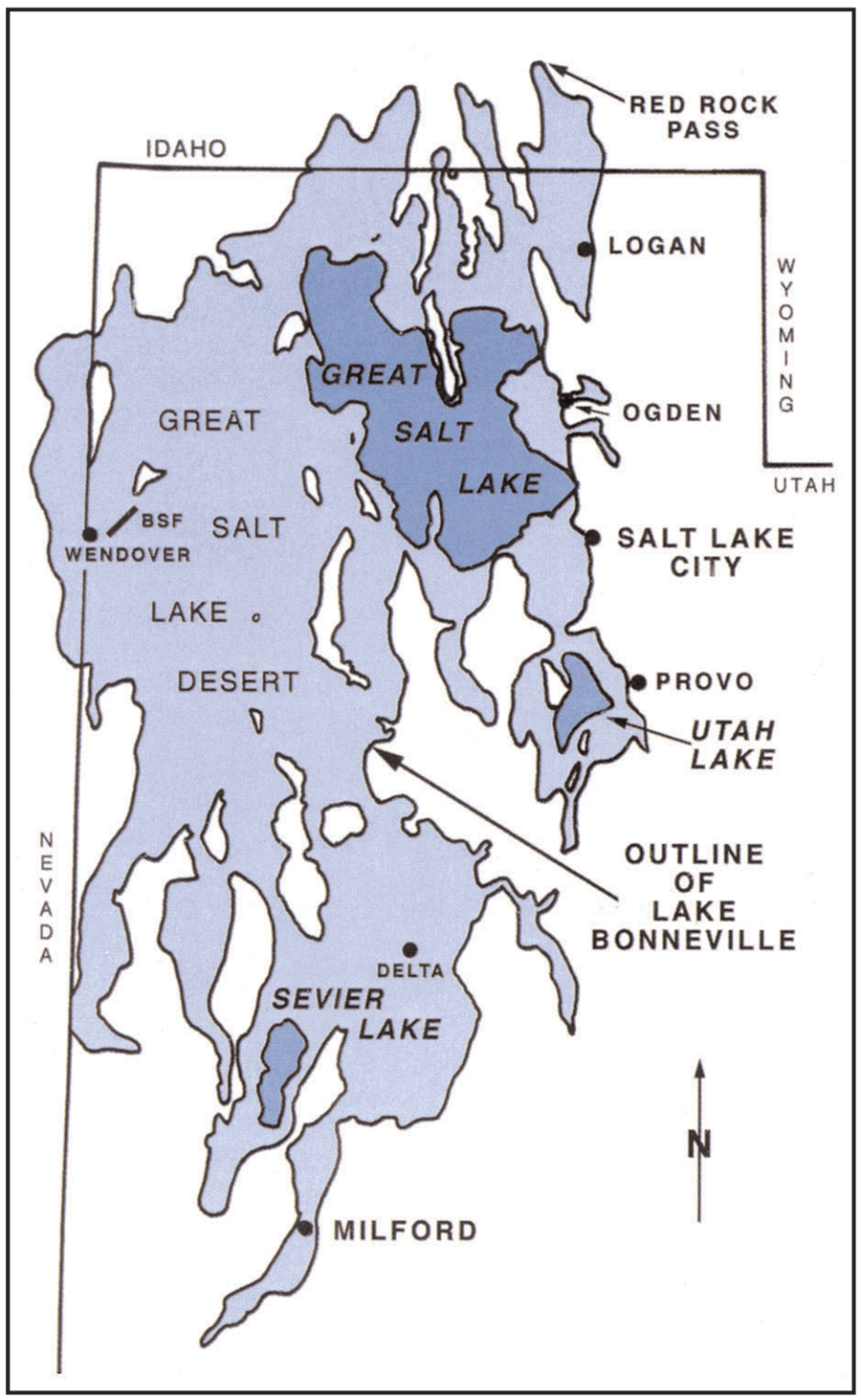
Lake Bonneville was a massive, Ice Age lake that existed from about 30,000 to 13,000 years ago. It occupied a low, bowl-shaped depression in the eastern Great Basin. At its largest extent, it spanned about 20,000 square miles of western Utah and parts of eastern Nevada and southern Idaho.
Lake Bonneville was about 325 miles long, 135 miles wide, and had a maximum depth of over 1,000 feet. It contained many islands that are the present-day mountain ranges of western Utah. Its relatively fresh water was derived from direct precipitation, rivers, streams, and meltwater from glaciers. During the time of Lake Bonneville, the climate was somewhat wetter and colder than now.
Lake Bonneville water levels started dropping significantly around 16,000 years ago when the climate began drying and warming, increasing evaporation and decreasing precipitation, which caused a shift in the water balance. In about 2,000 years, the lake had dropped to about the level of modern Great Salt Lake.
Image Caption: Outline of ancient Lake Bonneville and associated modern features (BSF = Bonneville Salt Flats)
Lake Bonneville Basics
 Lake Bonneville was a massive, Ice Age lake that existed from about 30,000 to 13,000 years ago. It occupied a low, bowl-shaped depression in the eastern Great Basin. At its largest extent, it spanned about 20,000 square miles of western Utah and parts of eastern Nevada and southern Idaho.
Lake Bonneville was about 325 miles long, 135 miles wide, and had a maximum depth of over 1,000 feet. It contained many islands that are the present-day mountain ranges of western Utah. Its relatively fresh water was derived from direct precipitation, rivers, streams, and meltwater from glaciers. During the time of Lake Bonneville, the climate was somewhat wetter and colder than now.
Lake Bonneville water levels started dropping significantly around 16,000 years ago when the climate began drying and warming, increasing evaporation and decreasing precipitation, which caused a shift in the water balance. In about 2,000 years, the lake had dropped to about the level of modern Great Salt Lake.
Image Caption: Outline of ancient Lake Bonneville and associated modern features (BSF = Bonneville Salt Flats)
Public Interest Articles
Great Salt Lake and Lake Bonneville Articles: 41


