Tag Archive for: Utah Geological Survey

Sunset on Gooseberry Mesa shines golden light on cliffs of Triassic-age Shinarump Conglomerate and the underlying slope-forming Moenkopi Formation. White cliffs and peaks in the distance are thrones and temples of Zion National Park, formed of Jurassic-age Navajo Sandstone. Gooseberry Mesa, Washington County, Utah Photographer: J. Lucy Jordan; © 2016

POTD 5-31-16 Washington County

Gooseberry Mesa, Washington County, Utah
Photographer: J. Lucy Jordan; © 2016

Sunset on Gooseberry Mesa shines golden light on cliffs of Triassic-age Shinarump Conglomerate and the underlying slope-forming Moenkopi Formation. White cliffs and peaks in the distance are thrones and temples of Zion National Park, formed of Jurassic-age Navajo Sandstone.

Lake Powell’s Gunsight Bay as seen from Alstrom Point, Kane County. Alstrom Point, Kane County, Utah Photographer: Marshall Robinson; © 2016

5-24-16

Alstrom Point, Kane County, Utah
Photographer: Marshall Robinson; © 2016

Lake Powell’s Gunsight Bay as seen from Alstrom Point, Kane County.

Just above its confluence with the Dirty Devil River, Happy Canyon deeply and abruptly cuts and sculpts the White Rim Sandstone of the Permian-age Cutler Formation. Happy Canyon, Garfield County, Utah Photographer: Gregg Beukelman; © 2016

POTD 5-17-16 Happy Canyon Garfield County

Happy Canyon, Garfield County, Utah
Photographer: Gregg Beukelman; © 2016

Just above its confluence with the Dirty Devil River, Happy Canyon deeply and abruptly cuts and sculpts the White Rim Sandstone of the Permian-age Cutler Formation.

solarindustrymag.com

new report from the Utah Geological Survey (UGS) highlights the increasingly significant role solar power is playing in the state’s diverse energy portfolio.

READ MORE

Did you see our 2016 Utah’s Energy Landscape is out? Read this feature on the new pub, and find the publication HERE.

deseretnews.com

Utah, identified four years ago by the U.S. Department of the Interior as one of six states in the country with prime solar potential, is riding a boom of new utility-scale developments harnessing the energy of the sun.

READ MORE

Wasatch Range east of Layton, Davis County, Utah Photographer: Ken Krahulec; © 2016

POTD 5-10-16 Wasatch Range Davis County

Wasatch Range east of Layton, Davis County, Utah
Photographer: Ken Krahulec; © 2016

standard.net

NORTH SALT LAKE — A thicket of litigation spawned by a 2014 landslide is scheduled to enter arbitration hearings in June, which North Salt Lake Mayor Len Arave hopes will pave the way for construction of an earthen bulwark intended to slow or stop the ground movement.

READ MORE

standard.net

Stand on the railroad causeway dividing the Great Salt Lake into two different bodies of water, and the tipping point for life in the lake becomes clear.

READ MORE

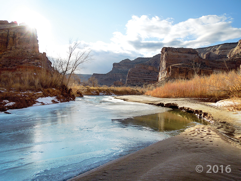
Short days and low winter sun cause ice to form along the San Rafael River where it cuts through the west flank of the San Rafael Swell. The 1,100-foot-deep canyon exposes the Jurassic-Triassic-age Glen Canyon Group along the cliffs and ledges of the canyon walls. Little Grand Canyon of the San Rafael River, Emery County, Utah Photographer: Zach Anderson; © 2016

POTD 5-3-16 San Rafael River Emery County

Little Grand Canyon of the San Rafael River, Emery County, Utah
Photographer: Zach Anderson; © 2016

Short days and low winter sun cause ice to form along the San Rafael River where it cuts through the west flank of the San Rafael Swell. The 1,100-foot-deep canyon exposes the Jurassic-Triassic-age Glen Canyon Group along the cliffs and ledges of the canyon walls.

Lower Bells Canyon Reservoir and glacially sculpted Bells Canyon, Wasatch Range, Salt Lake County. Bells Canyon, Wasatch Range, Salt Lake County, Utah Photographer: Jim Davis; © 2015

POTD 4-26-16 Bells Canyon Salt Lake County

Bells Canyon, Wasatch Range, Salt Lake County, Utah
Photographer: Jim Davis; © 2015

Lower Bells Canyon Reservoir and glacially sculpted Bells Canyon, Wasatch Range, Salt Lake County.