New, Novel, and Updated!
Wetland Mapping Improves Across Utah
by Peter Goodwin

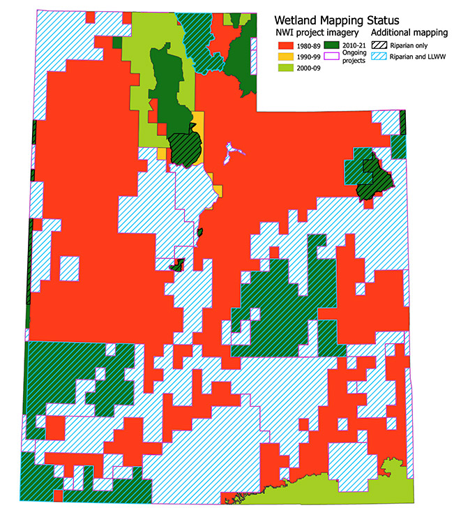
Age of National Wetland Inventory mapping projects across the state. The map also shows where ongoing projects are expected to replace outdated mapping by 2024 and the location of projects where riparian areas are also mapped and LLWW descriptions are applied.
Ask folks about Utah’s wetlands and they will either reply, “What wetlands? We live in a desert!” or mention Great Salt Lake. However, Utah contains a stunning variety of wetlands, from the bleak playas of the Bonneville Salt Flats to verdant wet meadows in the High Uinta Mountains supporting plants and wildlife more typically found in Arctic tundra. Their distribution is just as varied and wetlands can be found along rivers, dry valley bottoms, montane slopes, and occasionally people’s backyards. Wetland mapping attempts to capture this broad distribution and provide decision makers, resource managers, and the general public with an accurate depiction of wetland types and their locations. There are many ways to map wetlands and several datasets for each method, but the National Wetland Inventory (NWI) is the most used mapping dataset for a few reasons: seamless coverage across the U.S., imagery-based mapping that intuitively captures wetland boundaries, and a free and publicly accessible data portal and web map.
NWI mapping relies on interpretation of aerial imagery to identify areas supporting wetland vegetation like cattails, rushes, or cottonwoods and areas with flooding, standing water, or persistently saturated soils. This imagery-interpretation-based method produces legible mapping depicting wetlands that match expectations—rounded blobs with boundaries clearly following visible landscape features. However, this method also produces mapping with a “shelf-life” where the mapping represents a static snapshot of the moment the imagery was collected that can become outdated as changing hydrology, shifting land uses, or encroaching development reduce or replace wetlands. Much of the NWI for Utah was mapped using imagery collected during the 1980s and is severely outdated and inaccurate in several parts of the state.
Since 2014, the Utah Geological Survey (UGS) has been remapping parts of the state using modern, high-resolution imagery and updating the NWI to reflect current conditions and improve mapping accuracy (see Survey Notes, v. 49, no. 1, p. 1–2). Original NWI mapping only included features with true wetland vegetation and hydrology and failed to capture riparian areas near streams and lakes supporting distinct vegetation and wildlife communities. Recent UGS mapping projects have mapped riparian areas to identify these important, non-wetland habitats. The Bureau of Land Management (BLM) recently recognized the need for updated wetland mapping to support sound resource management and has started funding additional NWI mapping projects focusing on BLM-managed lands throughout the western U.S., with several projects occurring within Utah. Several of the UGS and BLM mapping projects are currently ongoing with an expected completion date in early 2024. Combined, these BLM and UGS projects will cover 51 percent of the state and will provide updated NWI mapping to 70 percent of the population. These ongoing BLM and UGS projects will also map riparian areas and enhance the NWI mapping by applying additional descriptions to each mapped wetland.
NWI mapping describes wetlands according to characteristics easily seen in imagery (dominant vegetation, flooding duration, and typical human impacts) but misses several characteristics such as the water source, geomorphic setting, and connectivity to other wetlands that are important for habitat management and resource conservation. To address this gap, the UGS and other organizations working on NWI mapping projects in the state have been enhancing recent NWI mapping with Landscape Position, Landform, Water Flow Path, and Waterbody Type (LLWW) descriptions. These LLWW descriptions identify the geomorphic setting, shape and form, and connectivity of a given wetland and include detailed modifiers to describe unique human impacts and wetland water sources. Combined, the NWI and LLWW descriptions provide detailed information about a wetland and allow identification of unique wetland types that would be unidentifiable with a single set of descriptions, such as isolated wet meadows supported by near-permanent groundwater, emergent wetlands temporarily inundated by river flooding, and montane forested wetlands. The combination of improved accuracy with the ability to distinguish a wide variety of wetlands supports several novel landscape-level analyses and greatly enhances the dataset’s utility for planning and management.

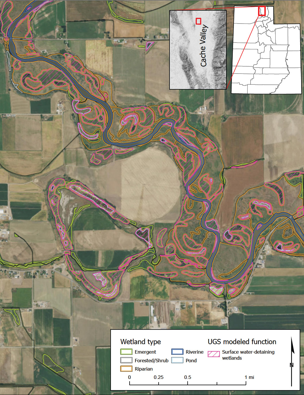
Mapping from UGS’s most recent mapping project showing updated wetland mapping along the floodplain of the Bear River in Cache Valley of northern Utah. Pink highlighting indicates wetlands likely to detain surface waters and attenuate floods.
The most common use of wetland mapping assesses wetland presence or absence on individual properties as an initial screen for wetland permit applications (see Survey Notes, v. 52, no. 1, p. 4–5). This use mostly ignores the wetland descriptions, but other uses such as setting management priorities, performing inventory and consequence analyses for environmental impact statements, establishing floodplain protection ordinances, or identifying conservation and restoration opportunities benefit from the flexibility of combined NWI and LLWW descriptions. Increasingly, local communities are considering the beneficial functions of wetlands in land use decisions and are prioritizing conservation of high-functioning wetlands. To support these decisions, the UGS leveraged the NWI and LLWW descriptions to identify which wetlands were likely to provide beneficial functions such as unique habitats, filtering sediments from runoff, or detaining floodwaters to create a spatial dataset that can be easily added to existing maps or analyses.
By 2024, about one-half of Utah will have modern NWI mapping, mapped with increased accuracy standards and imagery collected within the past 10 years. This NWI wetland mapping dataset is invaluable for permitting, planning, and resource management and can be freely accessed and downloaded through the NWI Wetlands Mapper or the UGS Wetlands web app. LLWW descriptions have only been recently applied to wetland mapping in Utah and there currently is no online portal to access and download the LLWW-enhanced mapping. However, the UGS can provide copies of the mapping to anyone interested in using the enhanced mapping or exploring possible applications. For more information about wetland mapping or Utah’s wetlands, visit our wetlands page.


