Springhill Landslide, North Salt Lake
The Utah Geological Survey (UGS) has been monitoring conditions at the Springhill landslide in North Salt Lake, Davis County, since 1998. This landslide ultimately destroyed 18 homes over 15 years. The Springhill landslide is about 720 feet long and about 290 feet wide where it is crossed by Springhill Drive. The local relief (change in elevation) is about 150 feet and the average slope of the landslide is approximately 21 percent (the ground rises 21 feet over a distance of 100 feet). The depth of the landslide varies along its length. Along the north edge of Springhill Circle, the landslide is about 48 feet deep and likely deeper than 70 feet beneath Springhill Drive. The landslide is shallower along its southern edge and in the head and toe.
Geologic Information
The landslide formed in an old gravel quarry where gravels from ancient Lake Bonneville were excavated for construction-use nearly down to a layer of highly weathered clay-rich volcanic ash, sand, and silt (tuffaceous rock). This weak, poorly drained layer of clay-rich tuffaceous rock at the base of the landslide (forming the slide plane) and ample groundwater likely account for the decades of recurrent creep along this gentle slope. In places the tuffaceous rock is also overlain by a unit of volcanic rock fragments. The Wasatch fault zone crosses the lowermost part of the slide and may have enhanced weathering and clay development by providing a prehistoric flowpath for rising deep, hot groundwater.
1998–2012: Early Landslide Movement

Damages from the Springhill Landslide in 2009, North Salt Lake, Utah. Photo: Francis Ashland and Ashley Elliott
In the late 1990s, residents in the Springhill area of North Salt Lake, Davis County, began noticing cracking and other distress related to relatively minor movement of the landslide. By 1998, the house at 160 Springhill Drive that straddled the northern boundary of the landslide was severely damaged and condemned. Relatively severe distress also occurred to several houses along Valley View Drive (formerly 350 East) and Springhill Circle.
Little movement or damage occurred during a dry period between 1999 and 2004, but the rate of movement accelerated during the 2005 wet year. Since 2005, the amount of movement each year has increased, except in 2007 and 2011–2012 (dry years), resulting in an increased amount of damage and distress, particularly to houses in the upper and lower parts of the landslide and to Springhill Drive.
2012: City of North Salt Lake Awarded Federal Grant

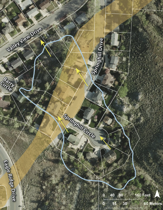
Aerial image with the landslide boundary (light blue line) in 2009. Yellow arrows show landslide movement direction. Yellow highlighted area is the Wasatch fault zone.
In an effort to assist the City of North Salt Lake, the UGS was tasked to help identify the homes specifically impacted by the landslide. Using high-precision GPS monitoring and comparative analysis, the UGS provided compelling data to support the city with its grant request. On June 28, 2012, the City of North Salt Lake announced that they had been awarded an almost $2 million matching fund Federal Emergency Management Agency Pre-Disaster Mitigation Grant. That money, coupled with roughly $600,000 in matching funds from the city, was used to buy and demolish 12 homes, capture and channel spring water into a storm drain, and turn the landslide site into an open-space park.
2013: Springhill Geologic Park Designated
In the spring of 2013, all of the impacted homes were demolished, and land rehabilitation began. Roads were removed and the area was regraded to include a drainage system redirecting water away from the landslide. The City of North Salt Lake designated the land as a geologic park and placed a hiking trail with a small parking lot providing public access to the trail system above the landslide. The park was seeded with native vegetation and informative plaques were placed along the trail identifying vegetation types and geologic features of the landslide. When visiting the park, look for remnants of landscaping features from demolished homes, ground distortion from ongoing landslide movement, and the new drainage system used to capture and divert spring water.
For more information, check out our Springhill Geologic Park GeoSights article!
2013–Present Day: Ongoing Landslide Monitoring
After the area was rehabilitated into a city park, GPS monitoring was reestablished and new monitoring began. The frequency of monitoring was reduced to identify landslide activity and is primarily performed after heavy snowpack winters. Since the park was created, the landslide has shown activity, but in slow phases of movement, with the most movement at the top or head of the landslide. As an urban landslide, Springhill landslide will continue to be monitored and observed as it poses a hazard to the surrounding community.
Landslide Conditions Archive
Landslide Conditions Archive
These pages were intended to provide relatively frequent updates on landslide conditions, including movement amounts, changes in the rate of movement, groundwater levels that affect stability, and UGS activities. The data presented are provisional and subject to review and revision.
Springhill Landslide, North Salt Lake


