Volcanic Hazards
Volcanic hazards are typically those associated with active volcanoes and include volcanic eruptions of lava, ash, steam, and pyroclastics (rock material ejected during an explosive eruption); lava and pyroclastic flows; lahars (volcanic debris flows); glacier outburst floods; rock, debris, and ice avalanches; lateral blasts; tsunamis; and dome growth and collapse. While Utah does not have any active volcanoes, several basalt flows in the West Desert area are only several hundred years old. In addition, eruptions of volcanoes in the western United States, including the Yellowstone caldera, could result in volcanic ash clouds and significant deposition in Utah.

Volcano Types and Hazards
Active volcanoes, especially composite volcanoes (also known as stratovolcanoes), can present dangerous hazards to infrastructure and human life. Although Utah does not have active stratovolcanoes, there are cinder cones and shield volcanoes that are considered active in the scientific community due to the most recent eruptions around 10,000 years ago. The primary hazards related to volcanoes are:
- Volcanic Eruption: An eruption of molten rock from within the Earth and may be accompanied by lava, ash, steam, and pyroclastics. Can be violently explosive, such as the 1980 Mount St. Helens eruption, relatively benign as some Hawaiian volcanoes with slow moving lava flows, or somewhere in between.
- Lava Flow: A flow of molten rock on the Earth’s surface flowing out of a volcano.
Cinder Cone
- Shape: Steep conical hill with straight sides
- Size: Small, less than 300m high
- Materials: Cinders
- Eruption Type: Explosive
- Utah Example: Diamond Cinder Cone, Washington County

Shield Volcano
- Shape: Very gentle slopes; convex upward (shaped like a warrior’s shield)
- Size: Large, over 10s of kms across
- Materials: Fluid lava flows (basalt)
- Eruption Type: Quiet
- Utah Example: Cedar Hill, Box Elder County

Stratovolcano
- Shape: Gentle lower slopes, but steep upper slopes; concave upward
- Size: Large, 1-10 km in diameter
- Materials: Numerous layers of lava and pyroclastics
- Eruption Type: Explosive
- Utah Example: Mount Belknap, Tushar Mountains, and Monroe Peak, Sevier Plateau

Utah’s Volcanic History
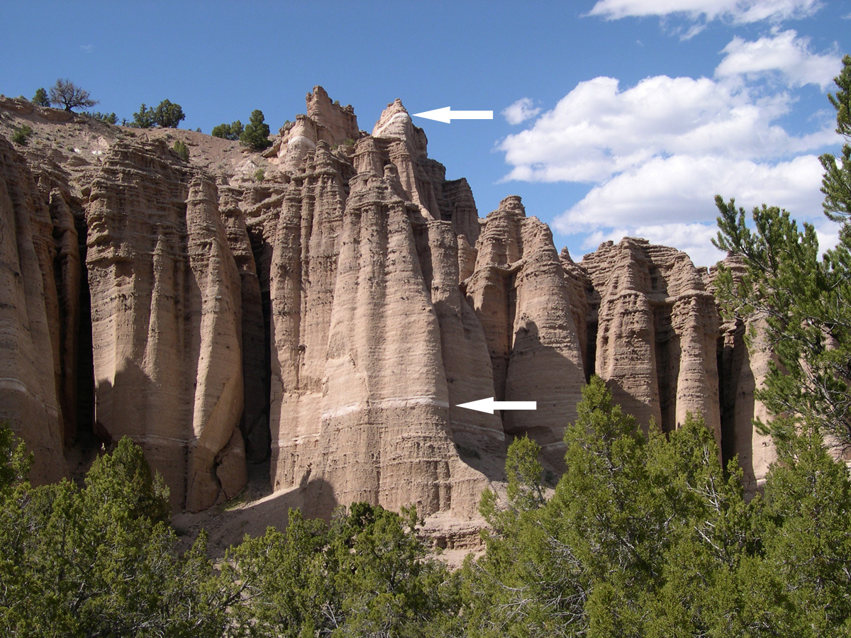
The two white layers within the Sevier River Formation, near the bottom and the top, are airfall volcanic ash deposits.
Stratovolcanoes erupted in western Utah between about 40 and 25 million years ago. At this time, Utah was closer to a continental-oceanic plate boundary where an oceanic plate (Farallon) was subducting underneath the North American continental plate. Stratovolcanoes are found at these types of plate boundaries. Today’s active stratovolcanoes include those in the Cascade Range in Washington, Oregon, and California where an oceanic plate (Juan de Fuca) is subducting underneath the North American continental plate.
Two examples of Utah’s stratovolcanoes are Mount Belknap in the Tushar Mountains and Monroe Peak on the Sevier Plateau. Because these volcanoes are old and have been extensively eroded, it is difficult to distinguish the original volcano shapes.
Shield volcanoes and cinder cones started to erupt about 12 million years ago after plate motions and resulting crustal forces changed. Compressional forces had eased, and the crust started to stretch between the Wasatch Range in Utah and the Sierra Nevadas in California. This extension created splintered zones in the Earth’s crust where magma rose to the surface creating shield volcanoes and cinder cones.