


New Core, New Insights into Ancient Lake Uinta Evolution and Uinta Basin Energy Resources
By Ryan Gall
Utah geologists are lucky to have outstanding outcrop exposures in every corner of the state. Our understanding of ancient Utah is built upon these outcrops and geologists from around the globe frequently travel here to study these irreplaceable sources of geologic information. However, outcrops lose some geologic information due to surface weathering that obscures sedimentary features and alters rock chemistry. Fine-grained rocks like claystone are especially prone to poor surface exposure as they break-down quickly and become rooting grounds for modern plants. In contrast, borehole core provides a rare glimpse of strata untouched by surface processes. Cores allow geologists to clearly see sedimentary features like ancient insect burrows and wave ripples in fine-grained rocks that help interpret ancient environments. In addition, cores provide an opportunity to collect geochemical data that can be used to reconstruct paleoenvironments and to characterize petroleum systems.
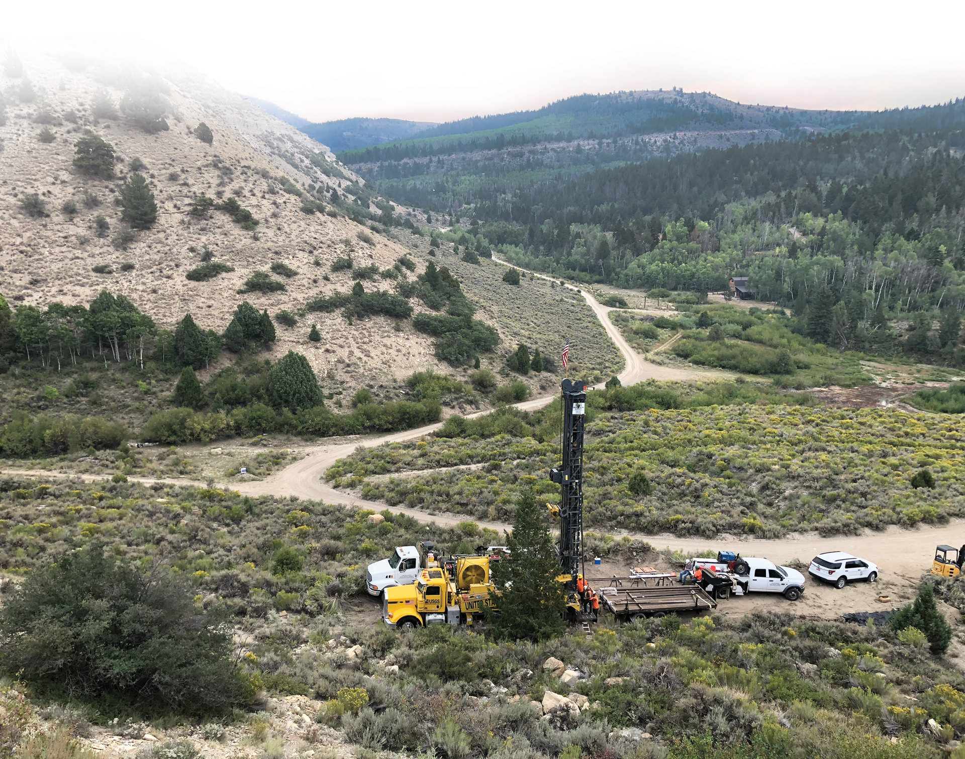
Willow Creek No. 1 field site (view to the east) with wireline coring rig in Willow Creek Canyon.
The Eocene-age Green River Formation in the Uinta Basin of northeastern Utah particularly benefits from core study. The Green River Formation was deposited about 55 to 43 million years ago in ancient Lake Uinta, which had similar characteristics to the modern Great Salt Lake (see Survey Notes, v. 46, no. 1, p. 1–3). With abundant fine-grained, organic-rich rocks deposited in the lake, the Green River Formation has gained global attention for its hydrocarbon resources and its paleoclimatic records from the Early Eocene Climatic Optimum (EECO), a period of elevated concentrations of atmospheric greenhouse gases (e.g., carbon dioxide) and extreme global temperatures. In the quest to understand the Eocene environment and better characterize our energy resources, the Utah Geological Survey (UGS) recently partnered with the U.S. Geological Survey (USGS) to drill a new 240-foot-long core from the Uinta Basin—Willow Creek No. 1.
The Willow Creek No. 1 core targets the Uteland Butte member and overlying Colton Tongue–Castle Peak interval of the lowermost Green River Formation. The Uteland Butte is a rising horizontal-well target that has produced over 15 million barrels of oil and over 21 billion cubic feet of natural gas (2010 to present, just from horizontal wells) from a >100-foot-thick interval of interbedded porous dolostone and limestone in the western Uinta Basin (see Survey Notes, v. 50, no. 2, p. 1–3). The Uteland Butte rocks represent the first widespread transgression (expansion) of ancient Lake Uinta. The overlying deposits represent a period of Lake Uinta regression (contraction) dominated by expansive river channels and soil development around the perimeter of the basin (Colton Tongue) and deposition of siliciclastic sediment (e.g., sand) in the relatively small Lake Uinta (Castle Peak). Since 2015, the Castle Peak interval has also been targeted with horizontal wells (28 at time of writing) and numerous vertical/directional wells.
The southwestern Uinta Basin provides a unique opportunity to study the Uteland Butte and Colton Tongue intervals in outcrop, but several details are missed due to heavy weathering and erosion. To obtain fresh rock material, a coring location was selected one mile from where the outcrop of the target interval dips into the subsurface. The site is in Willow Creek Canyon, 18 miles north of Price on a section of land owned by the Utah School and Institutional Trust Lands Administration (SITLA). This dual outcrop-core study will allow us to fully characterize the broad lateral variation of individual beds visible at the ground surface and use the core to collect geochemical data and make detailed observations. These important tasks will help us understand ancient lake-level fluctuations and aid in predicting future oil and gas development potential.
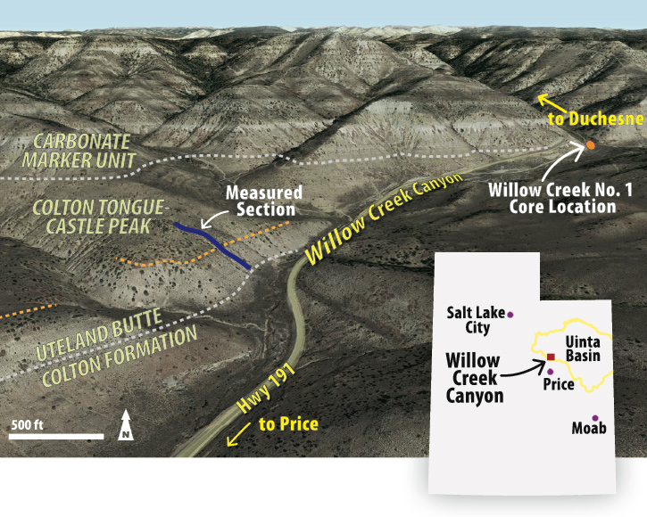
Oblique view of Willow Creek Canyon study area (view north) with overlain stratigraphy, measured section location, and coring location. Satellite images from Google Earth (Landsat/Copernicus 2018; accessed Jan 2019).
The core was drilled in mid-August 2018 by a crew from the USGS drilling program. It took only two days to prepare the site and drill 240 feet of core using a wireline coring rig with a special hollow drill bit and a 10-foot core barrel. Upon arrival at the surface, each 10-foot-long core interval was marked with the depth and “up direction” before being packaged for transport to the Utah Core Research Center (UCRC). Once at the UCRC, the core was cut in half―one side will remain in Utah while the other half will be housed at the USGS core facility in Lakewood, Colorado. UGS geologists are currently describing the core inch-by-inch, noting the lithology, sedimentary structures, fossils, and other characteristics. They will also create thin-section slides of selected zones for microscopic analysis and acquire elemental and mineralogical data. Colleagues at the USGS will collect additional mineralogical data and assess thermal properties of the organic matter.
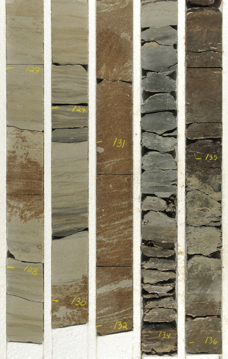
Core-box photo displaying depth-marked and slabbed sandstone with tar accumulation (left, 126.6–132.0 ft) and shallow lake deposits with freshwater bivalves (clams) (right, 132.0–136.0 ft) from the Colton Tongue–Castle Peak interval.
In addition to studying the new core, UGS geologists measured and described a 360-foot-thick stratigraphic section of the Uteland Butte member and Colton Tongue–Castle Peak interval in Willow Creek Canyon in October 2018. The geologists collected an additional 90 samples from quality outcrop exposures to aid geochemical characterization. Outcrop gamma-ray measurements were also taken every two feet along the measured section. These measurements tell us how the natural radioactivity of the rock varies by layer and is used to tie the outcrop to the gamma-ray log measured in the borehole.
Early observations from core and outcrop show surprising variation in depositional environments over the relatively small study interval. A clear look at the fine-grained rocks, coupled with geochemical analyses, shows that numerable rapid transgressive-regressive lake cycles are the dominant feature of the Uteland Butte and Colton Tongue intervals. These rapid cycles indicate a dynamic hydrologic regime that was incredibly responsive to environmental change and also created the conditions necessary to form dolomite, which acts as a major reservoir for oil and gas deeper in the basin.
Once detailed datasets from the core and outcrop are compiled, UGS geologists can look at basin-scale variation of the lower Green River Formation. This work begins with correlating the wireline logs (gamma, resistivity, porosity, density) collected from Willow Creek No. 1 to the oil and gas well logs and cores (also stored at the UCRC) from the central basin. The correlation will help determine the lateral extent of important strata and how transgressive-regressive cycles are expressed differently near the ancient shore and in the deeper basin. With ongoing collaboration with the USGS, the UGS will also assess the variation of organic maturity to help better understand oil and gas development potential.
This timely core-outcrop study is helping geologists understand some of Utah’s most important petroleum resources and the ancient processes that created them.
This timely core-outcrop study is helping geologists understand some of Utah’s most important petroleum resources and the ancient processes that created them. Given the high-quality data acquired from core and a plethora of outcrop exposures, the UGS has great interest in conducting similar studies of additional Uinta Basin strata to gain a deeper understanding of the evolution of lake basins and their resources.
ABOUT THE AUTHOR
