Special Study 166—Geologic Hazards of the Bullfrog and Wahweap High-Use Areas of Glen Canyon National Recreation Area
By Tyler R. Knudsen, Adam I. Hiscock, William R. Lund, and Steve D. Bowman
Media Inquiry:
Tyler Knudsen, Utah Geological Survey, (435) 865-9036 – tylerknudsen@utah.gov

PRESS RELEASE: New publication highlights rockfall, flash flooding and other natural hazards near Bullfrog and Wahweap areas of Lake Powell
Salt Lake City (June 15, 2020) – Stunning landscapes and a variety of recreational opportunities centered on Lake Powell attract nearly 4.4 million visitors annually to Glen Canyon National Recreation Area; however, the active geologic processes that shaped this rugged landscape can create hazardous conditions for visitors, employees, and infrastructure. To assist the National Park Service to manage and mitigate natural hazards, the Utah Geological Survey (UGS) completed a geologic-hazard investigation of two high-use sections of the recreation area: a 297-square-mile area near the Bullfrog and Halls Crossing Marinas, and a 117-square-mile area centered on the Wahweap and Antelope Point Marinas near the Utah-Arizona border. Results of this investigation include detailed geologic-hazard mapping that covers flooding and debris flows, rockfalls, landslides, soil erosion, and other problem soil and rock hazards, surface faulting, earthquake-induced liquefaction, and indoor radioactive gas (radon) potential.

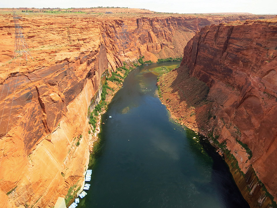
South-directed view of Glen Canyon and the Colorado River below Glen Canyon Dam. Canyon walls are jointed Navajo Sandstone. Talus deposits mantling lower slopes attest to the high rates of rockfall in the canyon. The photo was taken on May 11, 2014.
New visitors to Lake Powell may not be fully aware of many of these hazards, particularly rockfall and flash flooding, which are widespread and have caused injuries and fatalities in the recreation area and the surrounding region.
According to report lead author Tyler Knudsen, “Alcoves make attractive, sheltered places to moor your boat. Unfortunately, they also often produce rockfalls, so the more time spent beneath an alcove, the greater your chance of impact. Additionally, many of Lake Powell’s alcoves lie beneath the hanging mouths of normally dry drainages. These “dry falls” are not always apparent from below until it rains, and potentially damaging waterfalls suddenly plunge to the lake or canyon bottom below.”
This study provides vital information about geologic hazards on Lake Powell. Education about these geologic features can help boaters recognize signs of rockfall hazards such as abundant rock fractures or cracks and overhanging rock masses and then avoid these areas as much as possible.
UGS Special Study (SS) 166, Geologic Hazards of the Bullfrog and Wahweap High-Use Areas of Glen Canyon National Recreation Area, is available (PDF) for free from the UGS website at https://ugspub.nr.utah.gov/publications/special_studies/ss-166.pdf. Print-on-demand copies are available for purchase from the Natural Resources Map & Bookstore, 1-888-UTAHMAP, www.mapstore.utah.gov.
SS 166 describes the geologic hazards and provides background information on data sources, the nature and distribution of the hazards, and possible hazard-reduction measures. The geologic hazard mapping is available on the interactive Utah Geologic Hazards Portal at https://geology.utah.gov/apps/hazards/.
This work was made possible through the financial and logistical support of the National Park Service. The Utah Geological Survey, a division of the Utah Department of Natural Resources, provides timely scientific information about Utah’s geologic environment, resources, and hazards.


