Investigating Earthquake Hazard on the Southern Wasatch Fault Zone
By Adam I. Hiscock, Greg N. McDonald, and Michael D. Hylland
The Wasatch fault zone (WFZ), Utah’s longest and most active fault, has long been known to be a serious earthquake threat to the Wasatch Front region. In 1883, G.K. Gilbert, the pioneer and father of Utah geology, wrote a letter to the Salt Lake Daily Tribune warning residents of earthquake risk in Utah. Since then, great strides have been made to study and understand earthquakes along this major fault system to help reduce earthquake risk along the Wasatch Front. Most of this work has been conducted on the five central segments of the WFZ, leaving the northern and southern end segments relatively unstudied. An earthquake forecast, or probability model, for the WFZ was published in 2016 by the Working Group on Utah Earthquake Probabilities, but due to a lack of earthquake timing data, the end segments could not be characterized as rigorously as the central segments. This lack of data on the end segments hinders our ability to accurately model and forecast earthquakes on the entire WFZ.
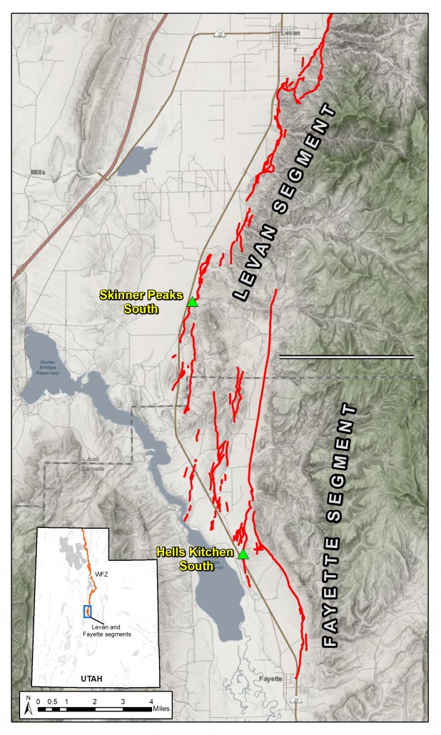
Both the Levan and Fayette segments on the southern end of the WFZ show evidence for generating large, surface-faulting earthquakes in the Holocene time period (about the past 12,000 years). However, previous paleoseismic (the geologic study of past earthquakes) research on both segments is limited. In 2015, Utah Geological Survey (UGS) geologists remapped the segments in great detail using new high-resolution digital topographic data. This new mapping has allowed us to identify previously unknown and unmapped traces of faults along these segments, and helped us in selecting sites for paleoseismic fault trenching investigations.
Investigations conducted in 1991 and again in 2008 on a natural exposure of the fault exposed by a stream cut on the Levan segment provided a timing estimate for the most recent large earthquake that occured on that segment (approximately 1000 years ago). A fault trenching investigation on the south end of the Levan segment, also in 1991, produced data consistent with a large earthquake around 1000 years ago, but was unable to document the timing of any earlier earthquakes. Finally, data collected by creating topographic profiles across Levan- and Fayette-segment fault scarps has provided insights into earthquake rupture on both segments. Despite this past work, many unanswered questions remain about earthquake activity on these southernmost segments of the WFZ: How often do large earthquakes occur on these segments and how episodic or random are they? Do earthquakes rupture only the Levan segment or Fayette segment, or do they rupture and spill-over from one segment to the other? What role does local geology play in faulting on these segments? How does the nature of faulting on these segments compare to faulting on the central segments of the WFZ (e.g., the Salt Lake City and Provo segments)?
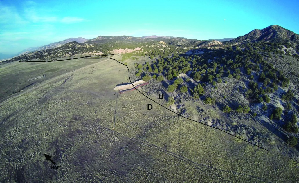
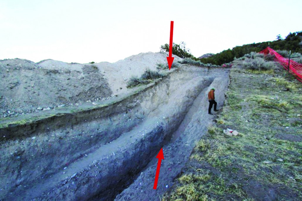
To attempt to answer these questions and more the UGS, aided by the U.S. Geological Survey (USGS), conducted a fault trenching investigation of prehistoric surface-faulting earthquakes on the Levan and Fayette segments in October of 2017. We excavated one trench at the Skinner Peaks South site on the Levan segment and one trench at the Hells Kitchen South site on the Fayette segment. The excavations were open for about a month while we worked to collect data and map the exposures.
At the Skinner Peaks South site, we excavated a trench across a 10- to 13-foot-high scarp. We mapped five stratigraphic units in the trench, including highly weathered volcanic bedrock in the bottom of the trench and sandy alluvial-fan gravels containing several prominent buried soil horizons. At the Hells Kitchen South site, we excavated a trench across a 3- to 6-foot high scarp. This trench exposed mostly coarse-grained alluvial-fan deposits and a loess (wind-blown fine sand) deposit at the bottom of the trench, and we mapped four stratigraphic units. We map the trench-wall exposures on high-resolution photomosaic images in the field, and then digitize our mapping back in the office later.
Our preliminary findings include evidence for two surface-rupturing earthquakes at the Skinner Peaks South site and one surface-rupturing earthquake at the Hells Kitchen South site. We collected 20 samples for radiocarbon (14C) dating and= 15 samples for optically stimulated luminescence (OSL) dating. Combined with our stratigraphic mapping, the dating results will be used to develop earthquake timing models and recurrence intervals for the Levan and Fayette segments. Our final report will be published in the Paleoseismology of Utah Series, a UGS series of reports pertaining to the study of past earthquakes in Utah. Eventually, our results will be incorporated into the USGS’s National Seismic Hazard Maps, which are used by local engineers and architects to adequately plan and design for development and reduce earthquake risk along the Wasatch Front region and elsewhere.
Studying the end segments of the WFZ is critical to helping us understand and forecast large earthquakes on the entire fault. Through this investigation and others, the UGS is working to fill gaps in earthquake data along the WFZ. We have recently completed detailed fault mapping for the entire fault zone (see Survey Notes v. 49, no. 3, p. 1–3). We are also working to secure funding to conduct a similar investigation on the northern end segments, specifically the Clarkston Mountain and Malad City segments in northern Utah and southern Idaho. These investigations will help Utahns better understand the hazard from large earthquakes on the WFZ and help us strengthen our earthquake resiliency.
Survey Notes, v. 51 no. 1, January 2019


