Using Gravity in a Multidisciplinary Approach to Better Understand the Subsurface at the Utah FORGE Site
by Christian L. Hardwick, May 2018

A composite model of the Utah FORGE site integrating multiple data types (geologic, thermal, gravity, seismic, hydrologic) depicts the subsurface bedrock geometry and temperature field which are key parameters to the FORGE project. The earth model output was generated using Leapfrog software (copyright © Aranz Geo Limited).
The Utah Frontier Observatory for Research in Geothermal Energy (FORGE) site near Milford, Utah, is one of two remaining sites in the competitive U.S. Department of Energy (DOE) initiative to locate and create a dedicated research laboratory where scientists and engineers will be able to develop and test enhanced geothermal system (EGS) technologies and techniques (see Survey Notes, v. 48, no. 3; v. 50, no. 1). The first objective of this project was locating a reservoir that fits all the critical parameters required by DOE (tight crystalline rock, 175˚–225˚C, 1.5 to 4 kilometers depth). We achieved this objective by using a multidisciplinary approach, combining different scientific survey techniques and data types, which gives us higher confidence on what we cannot see from the ground surface. While information from a wellbore is an excellent source for directly determining subsurface parameters, it is very expensive to drill a well and it only provides data for the immediate area surrounding the well (within a few meters [tens of feet]). For better understanding of a study area, we can augment wellbore information with geologic, hydrologic, geophysical, geochemical, and other types of data.
The most cost-efficient way to characterize subsurface bedrock geometry is by using geophysical surveys. At the Utah FORGE site, gravity surveying is one of the main geophysical survey types used because it is low-impact, non-invasive, and only requires 15 minutes per measurement for high-quality data. Earth’s gravity field, simply put, is primarily the result of the mass distribution beneath our feet. As the density and mass of a material increases, so does the gravity field. Within valleys filled with sediments, such as the one containing Milford, when density decreases the gravity field also decreases. These changes in the gravity field are called anomalies when they differ from expected gravity field values, and we in turn use these gravity anomalies to create models of the subsurface. These models help us identify underground structures and, in the case of the Utah FORGE study, estimate how deep the bedrock is in a valley filled with sediment.

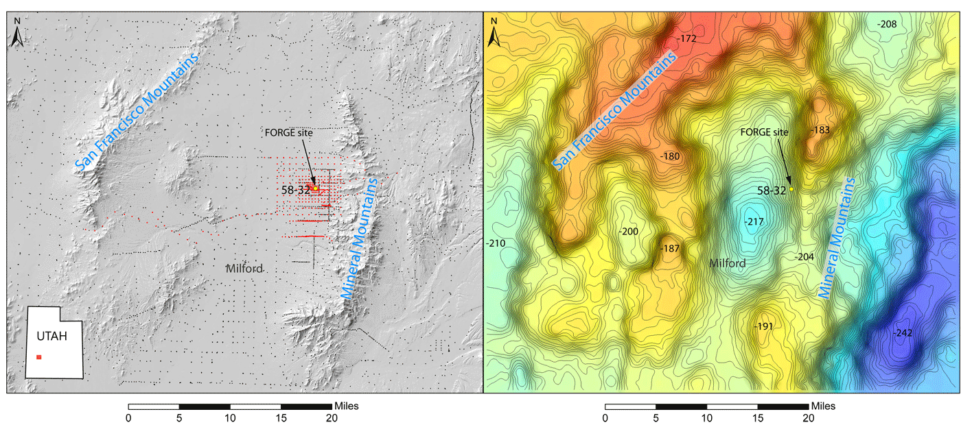
Maps of the Utah FORGE study area. Left panel: shaded elevation map showing the locations of the gravity survey stations, red dots are new stations, black dots are legacy data, FORGE well 58-32 indicated by yellow dot. Right panel: gravity anomaly field (same extent as left panel) with 1 mGal contours. Warm colors indicate gravity highs (typically mountain ranges) and cool colors are gravity lows (typically basin-fill sediments).
Gravity models also give insight into the structural controls of basins, groundwater flow/aquifers, seismic risk/hazards, and geothermal reservoirs. At first glance, prominent features are drawn from abrupt changes in the gravity field, known as high gradients, that indicate steeply dipping interfaces and/or faults hidden below the surface. High gravity gradients to the north and west of the FORGE site are inferred to be major fault offsets. Near the FORGE site, however, there are no notable gravity gradients that would indicate significant fault offsets hidden in the subsurface.

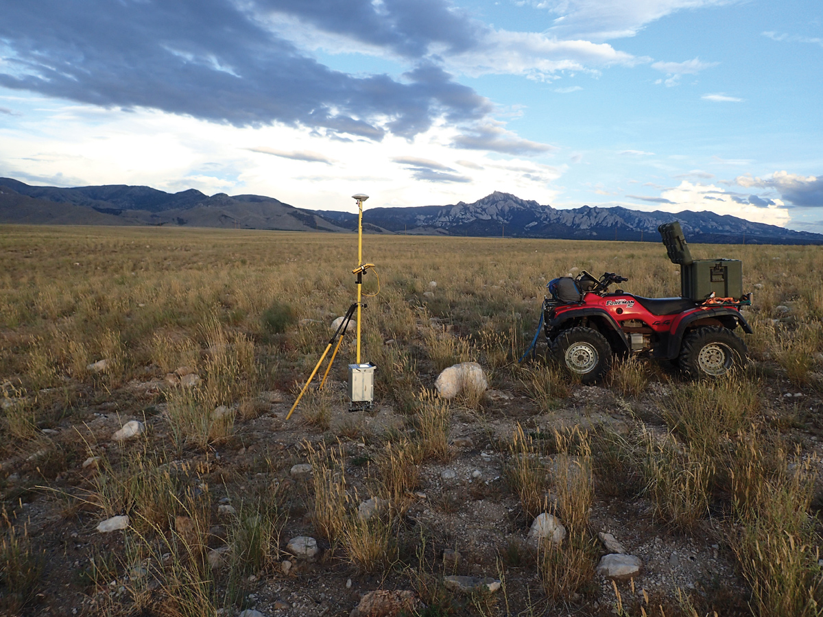
Gravity surveying near the Utah FORGE site, (Mineral Mountains in the background) using a Scintrex CG-5 autograv to measure the local gravity field.
In geothermal studies, the better we understand the thermal properties of rock and subsurface geometries, the better we can characterize the thermal regime and setting. The Utah Geological Survey operates a thermal laboratory where thermal conductivity, density, and specific heat are measured on samples obtained from well cuttings, core, and outcrop. These measured properties are crucial parameters in understanding thermal regimes. When we integrate known thermal properties of the local geology with subsurface geometry, we can generate a thermal regime of the subsurface and estimate the temperature at a given depth. Initial calculations estimated the minimum FORGE temperature of 175˚C would be reached between 1900 and 2400 meters (6234 and 7874 feet) depth, and the newly drilled FORGE well later confirmed this temperature at 2000 meters (6562 feet) depth. Results of the FORGE gravity surveys are consistent with independent 3D seismic interpretations for FORGE, which improves our confidence in the survey methods.
When we combine multiple methods and data types, we can better characterize and ultimately improve our understanding of a study area. We look forward to integrating subsequent FORGE data with current data sets to paint a more complete picture of the geothermal resource as the project advances.


