
Paradox Basin II DOE Class II Oil Revisit
Heterogeneous Shallow-shelf Carbonate Buildups in the Blanding Sub-basin of the Paradox Basin, Utah and Colorado: Targets for Increased Oil Production and Reserves Using Horizontal Drilling Techniques
Paradox Basin Study
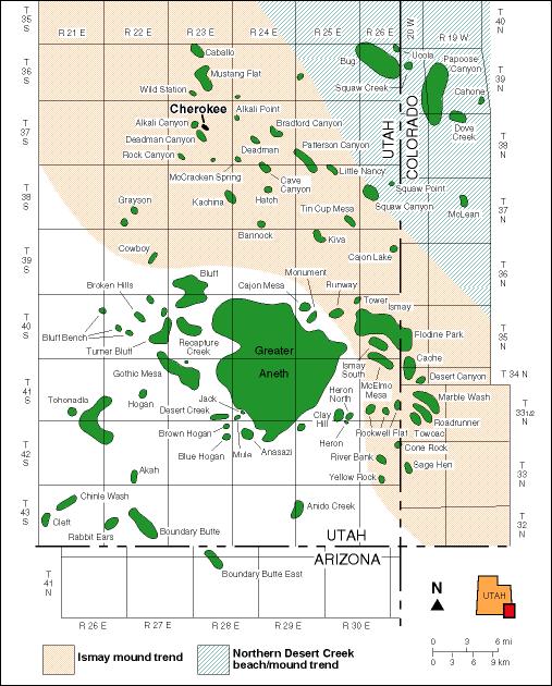
The Paradox Basin, which extends from Utah into portions of Colorado and Arizona, contains more than 75 small oil fields, each capable of producing 2 to 10 million barrels of oil. But variations in the reservoirs of these fields prevent recovery of up to 75 percent of that resource, using conventional extraction methods.
This study will evaluate methods to extract as much as another 50 million barrels of oil from existing wells in the basin. It will consist of a geologic and reservoir characterization study of the Ismay and Desert Creek zones of the 300-million-year-old Paradox Formation. The goal will be to determine if horizontal drilling techniques can increase well productivity from thin, untested intervals of reservoir rock. Cherokee field in San Juan County will be a target for a detailed case study.
The total cost of the project will be $1.03 million. Funding will come from the U.S. Department of Energy, the Utah Geological Survey, the Colorado Geological Survey, and private industry. The management and technical team, headed by UGS Principal Investigator Thomas C. Chidsey, Jr., will include Seeley Oil Company of Salt Lake City, the Colorado Geological Survey, and Eby Petrography & Consulting, Inc.
Deliverables
- 1.1.1 Regional Paradox Formation Structure and Isochore Maps, Blanding Sub-Basin, Utah (pdf)
- 1.1.2 Regional Paradox Formation Cross Sections, Blanding Sub-Basin, Utah and Colorado (pdf)
- 1.1.3 Regional Paradox Formation Facies Maps, Blanding Sub-Basin, San Juan County, Utah (pdf)
- 1.2.1A Thin Section Descriptions: Cherokee and Bug Fields, San Juan County, Utah (pdf)
- 1.2.1B Thin Section Descriptions: Little Ute and Sleeping Ute Fields, Montezuma County, Colorado (pdf)
- 1.2.2 Capillary Pressure/Mercury Injection Analysis: Cherokee and Bug Fields, San Juan County, Utah (pdf)
- 1.2.3 Scanning Electron Microscopy and Pore Casting: Cherokee and Bug Fields, San Juan County, Utah (pdf)
- 1.2.4 Carbon and Oxygen Isotopic Analysis: Bug, Cherokee and Patterson Canyon Fields, San Juan County, Utah (pdf)
- 1.2.5 Thin Section Epifluorescence: Cherokee and Bug Fields, San Juan County, Utah (pdf)
- 1.2.6 Thin Section Cathodoluminescence: Cherokee and Bug Fields, San Juan County, Utah (pdf)
- 1.3.1 Geophysical Well Log/Core Descriptions: Cherokee and Bug Fields, San Juan County, Utah, and Little Ute and Sleeping Ute Fields, Montezuma County, Colorado (pdf)
- 1.4.1 & 1.4.2 Cross Sections and Field Maps: Cherokee and Bug Fields, San Juan County, Utah, and Little Ute and Sleeping Ute Fields, Montezuma County, Colorado (pdf)
- 2.1.1 Porosity/Permeability Crossplots: Cherokee and Bug Fields, San Juan County, Utah, and Little Ute and Sleeping Ute Fields, Montezuma County, Colorado (pdf)
- 2.1.2 Production Analysis: Cherokee and Bug Fields, San Juan County, Utah(pdf)
- 2.2.1 Three-Dimensional Geologic Models and Reserve Calculations: Cherokee and Bug Fields, San Juan County, Utah
- 2.2.1B Three-Dimensional Geologic Models: Little Ute and Sleeping Ute Fields, Montezuma County, Colorado (pdf)
Reports
- Abstract (pdf)
- Statement of Work (pdf)
- Final Report (pdf – 46MB)
Poster Presentations
Regional Facies Trends in the Upper Ismay Zone of the Blanding Sub-Basin of the Paradox Basin, Utah: Aids for Identifying Possible Targets for Horizontal Drilling
David E. Eby, Eby Petrography & Consulting, Inc.
Thomas C. Chidsey, Jr., Craig D. Morgan, and Kevin McClure, Utah Geological Survey
- Abstract and Study Area (pdf)
- Regional Ismay Correlations (pdf)
- Facies Mapped (pdf )
- Regional Facies (pdf)
- Targeting Future Horizontal Wells (pdf)
Contact
For more information on the Paradox Basin II Project, contact Tom Chidsey, (801) 537-3364, email: tomchidsey@utah.gov.


