Ferron Sandstone DOE Engineering/Geoscience Program
Geological and Petrophysical characterization of the Ferron Sandstone for 3-D simulation of a fluvial-deltaic reservoir
Final Report (pdf)
Objectives and Project Description
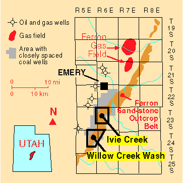
The primary objective of this project is to develop a comprehensive, interdisciplinary, and quantitative characterization of a fluvial-deltaic reservoir which will allow realistic inter-well and reservoir-scale modeling to be constructed for improved oil-field development in similar U.S. reservoirs. The geological and petrophysical properties of the Cretaceous Ferron Sandstone in east-central Utah will be quantitatively determined. Both new and existing data will be integrated into a three-dimensional representation of spatial variations in porosity, storativity, and tensorial rock permeability at a scale appropriate for inter-well to regional-scale reservoir simulation. Results could improve reservoir management through proper infill and extension drilling strategies, reduction of economic risks, increased recovery from existing oil fields, and more reliable reserve calculations. Transfer of the project results to the petroleum industry is an integral component of the project.
The project is divided into four tasks: (1) regional stratigraphic analysis, (2) case studies, (3) development of reservoir models, and (4) field-scale evaluation of exploration strategies. Regional stratigraphic analysis will provide a more detailed interpretation of the stratigraphy and gross reservoir characteristics of the Ferron Sandstone as exposed in outcrop. Case-studies will develop a detailed geological and petrophysical characterization, at well-sweep scale or smaller, of the primary reservoir lithofacies typically found in a fluvial-dominated deltaic reservoir. Tasks 3 and 4 will develop reservoir models and field-scale evaluations of exploration strategies. These tasks will incorporate data and results of the regional stratigraphic analysis and case-studies.
Project Performance Facts
The Ferron Sandstone project consists of $909,353 of non-federal cost sharing, which is over 54 percent of the total project cost. The project is currently within budget with approximately $500,000 remaining. Most project tasks are on schedule for final completion in the Fall of 1996; some deliverables have been submitted ahead of schedule while a few are slightly behind. The project is meeting original performance expectations with several additional spin-off products and results.
Participating Organizations
The following organizations are conducting work on the project: Utah Geological Survey* (prime contractor), AMOCO Production Company(* 93 percent cost share), Mobil Oil Corporation(* 100 percent cost share), University of Utah (Dept. of Geology and Geophysics)*, Brigham Young University (Dept. of Geology), Utah State University (Dept. of Mathematics and Statistics), P.B. Anderson (geological consultant)*, and The Aries Group (*indicates that the organization is contributing to cost sharing).
The Federal Government’s Engagement in this R&D
Industry R&D capacities are rapidly disappearing and small companies have little or no capabilities of their own. Drilling budgets and operation costs are dependent on the price of oil. Small fluctuations (decreases) in oil prices can cause these fields to become uneconomic and abandoned. For many operators, the cost of conducting detailed analysis of reservoir heterogeneity and developing reservoir models may be equal to a significant part of their net worth or their total investment in the fields. However, many of the operators tell us they would be eager to employ our Ferron Sandstone models in their fluvial-deltaic fields.
Federal and State governments have an economic interest in seeing increased production in these fields. Both receive direct revenues from mineral interests, royalties, and taxes. Both receive indirect benefit from increased economic activity. We envision this project as a prudent investment by government in maximizing return on the resources that government manages and regulates on behalf of the citizens of Utah and the U.S. Both the Federal and State governments have had an implicit partnership with oil producers since the time leases were issued or taxes levied. The DOE Geoscience/Engineering Reservoir Characterization Program and this project specifically, recognize that long term partnership, and seek to enhance production to mutual benefit.
Specific R&D Products/Accomplishments
The public technical and business benefits from this project will: (1) increase recoverable reserves by identifying untapped compartments created by reservoir heterogeneity, (2) increase deliverability by exploiting the reservoir along optimal fluid-flow paths, (3) enhance the application of new technologies, such as horizontal drilling, by identifying optimal drilling directions and locations to maximize fluid-flow, (4) identify reservoir trends for field extension drilling, (5) prevent premature abandonment of fluvial-dominated deltaic fields, (6) reduce development costs by more efficiently siting infill drilling locations, (7) allow limited energy investment dollars to be used more productively, and (8) increase royalty income to Federal, State, and local governments, fee owners, and the Ute Nation in Utah’s Uinta Basin (where most reservoirs on tribal lands are fluvial-dominated deltaic).
This type of work has not been performed on a large scale and with such broad applications. Much of the R&D work that has been done, is not available to the public because that research was performed by major oil companies for their internal use and is held confidential. However, because the Ferron project is Federally funded, the target includes all operators of fluvial-deltaic reservoirs especially those in the Gulf Coast, Rocky Mountain region, and Alaskan North Slope.
There has been one additional and significant benefit of the Ferron Sandstone project. The project was originally submitted to the DOE as study of a surface analogue to fluvial-dominated deltaic oil reservoirs. Since that time, the Ferron Sandstone itself has become a major coalbed methane play in Utah. Databases, strip logs, and maps produced from the project have become very useful to the numerous operators exploring and developing this new resource. Based on data generated in this project we estimate the play will support 3,400 wells, nearly doubling the total number of producing wells in Utah.
Expected R&P Products and Timetables
In addition to the products already released to the public (databases, strip logs, and maps), we expect to produce a useful final product by the Fall of 1996 (the end of the 3-year project contract. This final product from project milestones will include: (1) characterization of flow units influencing single well production, (2) reservoir simulation results, (3) exploration, development, and reserve estimation strategies, and (4) assessment of number and type of data needed to develop geologically-derived enhancements to fluvial-dominated deltaic reservoir models. Each completed or partially completed project milestone leads to progress on the next milestone. The completion of these milestones and the deliverables produced from them is a measurement of project success.
The market penetration rate for the industry will gaged by careful monitoring of those who use the project to increase production and reserves. The UGS has identified more than 60 operators (60+) that are following the project and waiting to use the results. The UGS will also sponsor field trips to the project area the review our work and conclusions. Follow-up contacts with these operators will be conducted to gage the success and implications of the project.
Utah Geological Survey (UGS), Salt Lake City, Utah 84114
Principal Investigator: M. Lee Allison, UGS
Phone: (801) 537-3300; fax: (801) 537-3400
Contract No. DE-AC22-93BC14896
| DOE PROGRAM MANAGER Robert Lemmon Contracting Officer’s Representative U.S. Department of Energy Bartlesville Project Office P.O. Box 1398 Bartlesville, OK 74005 (918) 337-4405 Fax: (918) 337-4418 |
STREET ADDRESS: 220 Noah Virginia Ave. Bartlesville, OK 74003Document Control Center U.S. Dept. of Energy Pittsburgh Energy Technology Center Wallace Road, Building 921 Pittsburgh, PA 15236 |
| PROJECT PARTICIPANTS | |
|---|---|
| AMOCO Chandra Rai AMOCO Production Co. P.O. Box 3385 Tulsa, OK 74102 (918) 660-3918 Fax: (918) 660-4245 Carl Sondergeld AMOCO Production Co. P.O. Box 3385 Tulsa, OK 74102 (918) 660-3917 Fax: (918) 660-4245AMOCO STREET ADDRESS: AMOCO Production Co. 4502 E. 41st Street Tulsa, OK 74135 ANDERSON, PAUL THE ARIES GROUP BRIGHAM YOUNG UNIVERSITY Thomas Morris MOBIL Bruce Welton |
Frank M. Wright, III Senior Reservoir Geologist Mobil Exploration/Producing Technical Center P.O. Box 819047 Dallas, TX 75381-9047 (214) 851-8667 Fax: (214) 851-8703 Telex: 650-478-7013MOBIL STREET ADDRESS: Mobil Research & Development 13777 Midway Road Dallas, TX 75244-4390 Receptionist phone: (214) 851-8814 UNIVERSITY OF UTAH Craig Forster/Stephen H. Snelgrove Richard Jarrard Ann Mattson UTAH GEOLOGICAL SURVEY Tom Chidsey, Program Manager STREET ADDRESS: UTAH STATE UNIVERSITY |
As of August 14, 1996
Adams, R.D., and Stapor, F.W., 1994, Response of delta morphology and progradational style to changes in accommodation, sedimentation, and basin topography: Ferron Sandstone, east-central Utah: Geologic Society of America Abstracts with Programs, v. 26, no. 7, p. 158.
Adams, R.D., 1995, The Cretaceous Ferron Sandstone of east-central Utah: a tale of three different morphologies for deltaic parasequences (abs.): American Association of Petroleum Geologist Bulletin, v. 79, no. 6, p. 914.
Adams, R.D., Snelgrove, S.H., and Forster, C.B., 1995, A methodology for obtaining detailed geologic descriptions to constrain 3-D reservoir fluid-flow simulation models in delta-front lithofacies (abs.): American Association of Petroleum Geologist Bulletin, v. 79, no. 6, p. 914.
Adams, R.D., Chidsey, T.C., Jr., and Laine, M.D., 1995, Integrated multidisciplinary reservoir characterization of a deltaic system-1: architecture and lithofacies of the Cretaceous-age Ferron Sandstone, east-central Utah (abs.): 1995 Annual Convention of the American Association of Petroleum Geologists, Official Program, p. 1A.
Anderson, P.B., and Ryer, T.A., 1995, Proposed revisions to parasequence-set nomenclature of the Upper Cretaceous Ferron Sandstone Member of the Mancos Shale (abs.): American Association of Petroleum Geologists Bulletin, v. 79, no. 6, p. 914-915.
Anderson, P.B., Ryer, T.A., and Chidsey, T.C., Jr., 1996, Ferron Sandstone – stratigraphy and reservoir analogs, east-central Utah (abs.): American Association of Petroleum Geologists Bulletin, v. 80, no. 6, p. 965.
Chidsey, T.C., Jr., 1995, Geological and petrophysical characterization of the Ferron Sandstone in Utah, for 3-D simulation of a fluvial-deltaic reservoir (abs.): American Association of Petroleum Geologists Bulletin, v. 79, no. 6, p. 916.
Dewey, J.A., Jr., Morris, T.H., and Ryer, T.A., 1995, Constraining reservoir models of fluvial- vs. wave-dominated delta-front sandstones through high resolution and high density sequence stratigraphic analysis, Ferron Sandstone, Utah (abs.): American Association of Petroleum Geologists Bulletin, v. 79, no. 6, p. 917.
Hucka, B.P., Sommer, S.N., Sprinkel, D.A., and Tabet, D.E., 1995, Ferron Sandstone drill-hole database, Ferron Creek to Last Chance Creek, Emery and Sevier Counties, Utah: Utah Geological Survey Open-File Report 317, 1130 p., 9 pl.
Hucka, B.P., Sommer, S.N., Sprinkel, D.A., and Tabet, D.E., 1995, Ferron Sandstone drill-hole database, Ferron Creek to Last Chance Creek, Emery and Sevier Counties, Utah: Utah Geological Survey Open-File Report 317DF, 5 p., 2 diskettes.
Mattson, Ann, and Chan, M.A., 1996, Facies relationships and statistical measures for reservoir heterogeneities in the Cretaceous Ferron Sandstone, central Utah (abs.): 1996 Annual Convention of the American Association of Petroleum Geologists, Program with Abstracts, p. A93.
Ryer, T.A., and Anderson, P.B., 1995, Parasequence sets, parasequences, facies distributions, and depositional history of the Upper Cretaceous Ferron deltaic clastic wedge, Utah (abs.): American Association of Petroleum Geologists Bulletin, v. 79, no. 6, p. 924.
Ryer, T.A., Dewey, J.A., Jr., and Morris, T.H., 1995, Distinguishing allocyclic and autocyclic causes of parasequence-level cyclicity–lessons from deltaic strata of the Upper Cretaceous Ferron Sandstone, central Utah (abs.): American Association of Petroleum Geologists Bulletin, v. 79, no. 6, p. 924.
Snelgrove, S.H., Forster, C.B., and Koebbe, J.V., 1995, Integrated multidisciplinary reservoir characterization of a deltaic system-2: developing a petrophysical model for reservoir simulation using data from the Ferron Sandstone, Utah (abs.): 1995 Annual Convention of the American Association of Petroleum Geologists, Program with Abstracts, p. 90-91A.
Snelgrove, S.H., Forster, C.B., Mattson, Ann, and Chan, M.A., 1996, Impact of lithofacies architecture and distribution on fluid flow: examples from the Creataceous Ferron Sandstone, east-central Utah (abs.): 1996 Annual Convention of the American Association of Petroleum Geologists, Program with Abstracts, p. A132.
Tabet, D.E., 1995, Utah’s 1994 coalbed methane gas developments: Utah Geological Survey, Survey Notes, v. 27, no. 2, p. 7-9.
Tabet, D.E., 1995, CBM in ‘dry county’ coalbed gas development expands in Utah: Coalbed Methane Review, issue 3, p. 11-13.
Tabet, D.E., Hucka, B.P., and Sommer, S.N., 1996, Geology of the Ferron Sandstone coalbed gas “fairway,” central Utah (abs.): 1996 Annual Convention of the American Association of Petroleum Geologists, Program with Abstracts, p. A137.
Utah Geological Survey, 1995, Ferron project ends first year with a bang!: Utah Geological Survey Petroleum News (July), p. 1-2.
Appendix References
Anderson, P.B., 1993, Stratigraphic and sedimentalogic characteristics of the lower portion of the Ferron Sandstone Member of the Mancos Shale along a portion of Muddy Creek, Emery County, Utah (abs.): American Association of Petroleum Geologists Bulletin, v. 77, no. 8, p. 1441.
Cotter, Edward, 1975, Deltaic deposits in the Upper Cretaceous Ferron Sandstone, Utah, in Broussard, M.L.S., editor, Deltas, models for exploration: Houston Geological Society, p. 471-484.
Gardner, M.H., 1993, Sequence stratigraphy and facies architecture of the Upper Cretaceous Ferron Sandstone Member of the Mancos Shale, east-central Utah: Unpublished Ph.D. dissertation, Colorado School of Mines, Golden, Colorado, 528 p. Gustason, E.R., 1993, Facies architectural analysis of progradational parasequence sets, upper coal-bearing Ferron Sandstone, central Utah: implications for reservoir description (abs.): American Association of Petroleum Geologists Bulletin, v. 77, no. 8, p. 1450.
Lufton, C.T., 1916, Geology and coal resources of Castle Valley in Carbon, Emery, and Sevier Counties, Utah: U.S. Geological Survey Bulletin 628, 88 p.
Ryer, T.A., 1981, Deltaic coals of Ferron Sandstone Member of Mancos Shale: predictive model for Cretaceous coal-bearing strata of western interior: American Association of Petroleum Geologists Bulletin, v. 65, no. 11, p. 2323-2340.
Ryer, T.A., 1982, Possible eustatic control on the location of Utah Cretaceous coal fields, in Gurgel, K.D., editor, Proceedings – 5th ROMOCO Symposium on the Geology of Rocky Mountain Coal: Utah Geological and Mineralogical Survey Bulletin 118, p. 89-93.
Ryer, T.A., 1991, Stratigraphy, facies, and depositional history of the Ferron sandstone in the canyon of Muddy Creek, east-central Utah, in Chidsey, T.C., Jr., editor, Geology of east-central Utah: Utah Geological Association Publication 19, p. 45-54. Ryer, T.A., 1993, The Upper Cretaceous Ferron Sandstone of central Utah: an overview (abs.): American Association of Petroleum Geologists Bulletin, v. 77, no. 8, p. 1459.
Ryer, T.A., and McPhillips, Maureen, 1983, Early Late Cretaceous paleogeography of east-central Utah, in Reynolds, M.W., and Dolly, E.D., editors, Mesozoic paleogeography of the west-central United States: Society of Economic Paleontologists and Mineralogists, Rocky Mountain Paleography Symposium 2, p. 253-272.
Contact
For more information on the Ferron Sandstone Project, contact Tom Chidsey, (801) 537-3364 or email: tomchidsey@utah.gov.