good4utah.com
We often talk about “the big one,” hitting the Beehive State. But now we’re learning it it happens it could mean trouble for Kennecott’s facility on the south slope.
good4utah.com
We often talk about “the big one,” hitting the Beehive State. But now we’re learning it it happens it could mean trouble for Kennecott’s facility on the south slope.
If you missed it a couple of weeks ago, here is an article outlining the paleoseismic study some of our UGS geologists helped with on a trench.
nextcity.org
Not far from I-215 in Salt Lake City, near the airport, a deep trench cuts through the earth. Though it looks like a sewer repair project, there’s nothing down here but dirt. And dirt, to the trained eye, can reveal quite a bit about a city’s future.
The USSC is the central state organization for reducing Utah’s earthquake risk by coordinating efforts, developing public policy, and disseminating results. Here you can find a large earthquake Salt Lake City scenario, and helpful booklet “Putting Down Roots” on preparing for earthquakes. Use the search to find all other USSC documents including photographs and PDFs. Visit the website HERE to help make a plan with your family and friends!
Other helpful links:
Where to Find Earthquake Information
Putting Down Roots PDF
A wonderful resource for earthquake safety and preparedness has just been released. The report was developed by the Utah Chapter of the Earthquake Engineering Research Institute (EERI) and was prepared for the Utah Seismic Safety Commission.
The Scenario for a Magnitude 7.0 Earthquake on the Wasatch Fault-Salt Lake City Segment: Hazards and Loss Estimates report provides information about the effects of the Wasatch fault scenario earthquake-in particular, how long it may take the state of Utah and its residents to fully recover and the potential long-term impacts on Utah’s economy. The ultimate goal of this report is to catalyze public and private actions that will increase pre-disaster resiliency through earthquake preparedness-being prepared to WITHSTAND, to RESPOND, and to RECOVER.
Follow this link to obtain a PDF copy HERE!

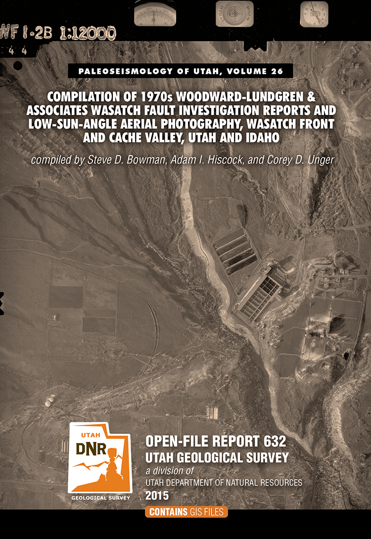
By: Steve D. Bowman, Adam I. Hiscock, and Corey D. Unger
This nine DVD set contains a descriptive 8-page report and digital files created from the Wasatch fault investigation project performed for the Utah Geologic and Mineralogical Survey (now the Utah Geological Suvey) and U.S. Geological Survey by Woodward-Lundgren & Associates. The project was performed to identify surface fault rupture hazard areas along the Wasatch fault in Cache Valley. This compilation contains digital scans of three separate Wasatch fault reports, 47 fault maps, and 1382 scanned low-sun-angle-arial photographs (frames). The digital files include aerial photograph scans in TIFF format, fault maps in TIFF and Adobe PDF formats, and index maps in Google Earth KMZ, GIS shapefile and Adobe PDF formats. Specialized software (not included) is required to utilized the Google Earth and GIS files, and can be downloaded from the internet.
This compilation will be useful for professionals involved with paleoseismology investigations; land-use planning and management; government agencies; and the general public and others as a historical archive. Low-sun-angle aerial photography was used to highlight certain topographic features, such as fault scarps and traces, for mapping purposes.
Maybe some of you have seen the new movie “San Andreas.” So what could we expect to happen in the event of a giant earthquake on the San Andreas Fault? Read more in this article to find out.
smithsonianmag.com
Like California, Utah is also earthquake country. One of the best forms of preparation is educating yourself and your family on what to do in the event of an earthquake. For more information on what you can do, see Putting Down Roots, or visit www.bereadyutah.gov.
usgs.gov
A team of scientists from the USGS Geological Hazards Science Center, led by Mendenhall Postdoctoral Fellow Scott Bennett and Research Geologists Ryan Gold, Richard Briggs, Christopher DuRoss, and Stephen Personius are collaborating with scientists at the Utah Geological Survey to gather data from new paleoseismic trenches along the Wasatch fault zone. These new datasets will help researchers to understand if past surface-rupturing earthquakes have spanned fault segment boundaries. They are also analyzing new high-resolution airborne LiDAR topographic data to characterize previously unmapped fault traces and to measure how vertical displacements (vertical offset of the ground surface from faulting) vary, both in space (from north to south) and time (the last 20,000 years).
Includes Utah earthquake fault information and county fault maps.
In Christchurch, New Zealand in February, 2011, a magnitude 6.3 earthquake struck six miles from the city center. The sandy type of soil present in the area caused the ground to basically liquefy during shaking.
UGS Geologist Chris DuRoss is interviewed by KCPW: Explore Utah Science to discuss the hazard of liquefaction we face right here in the the Salt Lake Valley.

Michael Hylland, a geologist at the Utah Geological Survey, examines disruptions in the subsurface soil at a trench dug through a section of the Wasatch Fault
mormontimes.com
If highway construction projects have taught commuters anything, it’s that even a single lane restriction can bring traffic to a crawl. Now imagine the impact on your commute because of a unexpected force of nature — like a strong earthquake, a blizzard, flooding rains or a tornado.
Along Utah’s Wasatch front, a fault spans 240 miles, and 80 percent of Utah residents live along its path.
The Utah Geological Survey notes the fault “has the dubious distinction of being one of the longest and most active normal faults in the world.”
Other areas of the country are also near fault lines. And along the Wasatch fault, several dozen freeway overpasses cross the main corridors near which the fault travels.
Other areas are more prone to conditions that tornadoes form in. And others live in the paths of hurricanes. Still, blizzards, fires and other storms can prompt evacuations or paralyze an area.
good4utah.com
We often talk about “the big one,” hitting the Beehive State. But now we’re learning it it happens it could mean trouble for Kennecott’s facility on the south slope.
If you missed it a couple of weeks ago, here is an article outlining the paleoseismic study some of our UGS geologists helped with on a trench.
nextcity.org
Not far from I-215 in Salt Lake City, near the airport, a deep trench cuts through the earth. Though it looks like a sewer repair project, there’s nothing down here but dirt. And dirt, to the trained eye, can reveal quite a bit about a city’s future.
The USSC is the central state organization for reducing Utah’s earthquake risk by coordinating efforts, developing public policy, and disseminating results. Here you can find a large earthquake Salt Lake City scenario, and helpful booklet “Putting Down Roots” on preparing for earthquakes. Use the search to find all other USSC documents including photographs and PDFs. Visit the website HERE to help make a plan with your family and friends!
Other helpful links:
Where to Find Earthquake Information
Putting Down Roots PDF
A wonderful resource for earthquake safety and preparedness has just been released. The report was developed by the Utah Chapter of the Earthquake Engineering Research Institute (EERI) and was prepared for the Utah Seismic Safety Commission.
The Scenario for a Magnitude 7.0 Earthquake on the Wasatch Fault-Salt Lake City Segment: Hazards and Loss Estimates report provides information about the effects of the Wasatch fault scenario earthquake-in particular, how long it may take the state of Utah and its residents to fully recover and the potential long-term impacts on Utah’s economy. The ultimate goal of this report is to catalyze public and private actions that will increase pre-disaster resiliency through earthquake preparedness-being prepared to WITHSTAND, to RESPOND, and to RECOVER.
Follow this link to obtain a PDF copy HERE!
By: Steve D. Bowman, Adam I. Hiscock, and Corey D. Unger
This nine DVD set contains a descriptive 8-page report and digital files created from the Wasatch fault investigation project performed for the Utah Geologic and Mineralogical Survey (now the Utah Geological Suvey) and U.S. Geological Survey by Woodward-Lundgren & Associates. The project was performed to identify surface fault rupture hazard areas along the Wasatch fault in Cache Valley. This compilation contains digital scans of three separate Wasatch fault reports, 47 fault maps, and 1382 scanned low-sun-angle-arial photographs (frames). The digital files include aerial photograph scans in TIFF format, fault maps in TIFF and Adobe PDF formats, and index maps in Google Earth KMZ, GIS shapefile and Adobe PDF formats. Specialized software (not included) is required to utilized the Google Earth and GIS files, and can be downloaded from the internet.
This compilation will be useful for professionals involved with paleoseismology investigations; land-use planning and management; government agencies; and the general public and others as a historical archive. Low-sun-angle aerial photography was used to highlight certain topographic features, such as fault scarps and traces, for mapping purposes.
Maybe some of you have seen the new movie “San Andreas.” So what could we expect to happen in the event of a giant earthquake on the San Andreas Fault? Read more in this article to find out.
smithsonianmag.com
Like California, Utah is also earthquake country. One of the best forms of preparation is educating yourself and your family on what to do in the event of an earthquake. For more information on what you can do, see Putting Down Roots, or visit www.bereadyutah.gov.
usgs.gov
A team of scientists from the USGS Geological Hazards Science Center, led by Mendenhall Postdoctoral Fellow Scott Bennett and Research Geologists Ryan Gold, Richard Briggs, Christopher DuRoss, and Stephen Personius are collaborating with scientists at the Utah Geological Survey to gather data from new paleoseismic trenches along the Wasatch fault zone. These new datasets will help researchers to understand if past surface-rupturing earthquakes have spanned fault segment boundaries. They are also analyzing new high-resolution airborne LiDAR topographic data to characterize previously unmapped fault traces and to measure how vertical displacements (vertical offset of the ground surface from faulting) vary, both in space (from north to south) and time (the last 20,000 years).
Includes Utah earthquake fault information and county fault maps.
In Christchurch, New Zealand in February, 2011, a magnitude 6.3 earthquake struck six miles from the city center. The sandy type of soil present in the area caused the ground to basically liquefy during shaking.
UGS Geologist Chris DuRoss is interviewed by KCPW: Explore Utah Science to discuss the hazard of liquefaction we face right here in the the Salt Lake Valley.
Michael Hylland, a geologist at the Utah Geological Survey, examines disruptions in the subsurface soil at a trench dug through a section of the Wasatch Fault
mormontimes.com
If highway construction projects have taught commuters anything, it’s that even a single lane restriction can bring traffic to a crawl. Now imagine the impact on your commute because of a unexpected force of nature — like a strong earthquake, a blizzard, flooding rains or a tornado.
Along Utah’s Wasatch front, a fault spans 240 miles, and 80 percent of Utah residents live along its path.
The Utah Geological Survey notes the fault “has the dubious distinction of being one of the longest and most active normal faults in the world.”
Other areas of the country are also near fault lines. And along the Wasatch fault, several dozen freeway overpasses cross the main corridors near which the fault travels.
Other areas are more prone to conditions that tornadoes form in. And others live in the paths of hurricanes. Still, blizzards, fires and other storms can prompt evacuations or paralyze an area.
![]()
The Utah Geological Survey (UGS) is a division of the Utah Department of Natural Resources. Several specialized programs comprise the UGS: Data Management, Energy & Minerals, Geologic Hazards, Geologic Information & Outreach, Geologic Mapping, Groundwater & Wetlands, and Paleontology.