Tag Archive for: utah

nationalgeographic.com

This loop out of St. George, Utah, explores an out-of-the-way corner of the U.S. Southwest. Even in the shadows of Zion and Grand Canyon National Parks, it’s easy to lose the crowds and find your own relatively private pocket of high desert—including a campsite on the rim of America’s most famous gorge that you might very well have all to yourself. So grab a coffee and sandwich en route at River Rock Roasting Company in La Verkin (dig the view off the back patio) and head east into a sandstone wonderland.

READ MORE

Just above its confluence with the Dirty Devil River, Happy Canyon deeply and abruptly cuts and sculpts the White Rim Sandstone of the Permian-age Cutler Formation. Happy Canyon, Garfield County, Utah Photographer: Gregg Beukelman; © 2016

POTD 5-17-16 Happy Canyon Garfield County

Happy Canyon, Garfield County, Utah
Photographer: Gregg Beukelman; © 2016

Just above its confluence with the Dirty Devil River, Happy Canyon deeply and abruptly cuts and sculpts the White Rim Sandstone of the Permian-age Cutler Formation.

Have you found him the perfect gift yet? This year, give him the gift of adventure. Check out these great books at our Map & Bookstore! A boating dad’s guide to Lake Powell.

Fathers Day Lake Powell Boating

Boater’s Guide to Lake Powell

(map) Lake Powell South

Wasatch Range east of Layton, Davis County, Utah Photographer: Ken Krahulec; © 2016

POTD 5-10-16 Wasatch Range Davis County

Wasatch Range east of Layton, Davis County, Utah
Photographer: Ken Krahulec; © 2016

huffingtonpost.com

A new species of horned dinosaur has been unearthed by scientists in southern Utah.

READ MORE

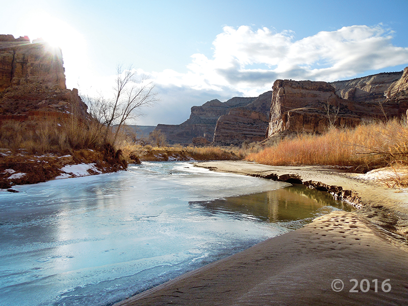
Short days and low winter sun cause ice to form along the San Rafael River where it cuts through the west flank of the San Rafael Swell. The 1,100-foot-deep canyon exposes the Jurassic-Triassic-age Glen Canyon Group along the cliffs and ledges of the canyon walls. Little Grand Canyon of the San Rafael River, Emery County, Utah Photographer: Zach Anderson; © 2016

POTD 5-3-16 San Rafael River Emery County

Little Grand Canyon of the San Rafael River, Emery County, Utah
Photographer: Zach Anderson; © 2016

Short days and low winter sun cause ice to form along the San Rafael River where it cuts through the west flank of the San Rafael Swell. The 1,100-foot-deep canyon exposes the Jurassic-Triassic-age Glen Canyon Group along the cliffs and ledges of the canyon walls.

Lower Bells Canyon Reservoir and glacially sculpted Bells Canyon, Wasatch Range, Salt Lake County. Bells Canyon, Wasatch Range, Salt Lake County, Utah Photographer: Jim Davis; © 2015

POTD 4-26-16 Bells Canyon Salt Lake County

Bells Canyon, Wasatch Range, Salt Lake County, Utah
Photographer: Jim Davis; © 2015

Lower Bells Canyon Reservoir and glacially sculpted Bells Canyon, Wasatch Range, Salt Lake County.

sltrib.com

Signs of earthquakes are everywhere in the chaotically beautiful geology of southwest Utah and the region where the mile-high Colorado Plateau falls off into the corrugated Basin-and-Range landscape that dominates neighboring Nevada.

READ MORE

thespectrum.com

Signs of earthquakes are everywhere in the chaotically beautiful geology of southwest Utah and the region where the mile-high Colorado Plateau falls off into the corrugated Basin-and-Range landscape that dominates neighboring Nevada.

READ MORE

Small cave-like features called tafoni pockmark the walls of a slot canyon in the southern San Rafael Swell, Emery County. San Rafael Swell, Emery County, Utah Photographer: Mark Milligan; © 2015

An afternoon escape—

POTD 4-19-16 San Rafael Swell

San Rafael Swell, Emery County, Utah
Photographer: Mark Milligan; © 2015

Small cave-like features called tafoni pockmark the walls of a slot canyon in the southern San Rafael Swell, Emery County.