Tag Archive for: utah

huffingtonpost.com

They’re called “Miracles of Nature,” and it’s not possible to find a higher concentration of them anywhere in the world outside of Utah. Arches National Park contains so many natural red sandstone arches that there isn’t a specific count (over 2000 have been found in the park), and erosive forces over the course of time mean they’re constantly being created (by erosion) and destroyed (through natural collapses) in a geologically dynamic desert landscape.

READ MORE

Folded pegmatite vein in Farmington Canyon Complex gneiss, Pearsons Canyon, Box Elder County. Pearsons Canyon, Box Elder County, Utah Photographer: Adam McKean; © 2014

What’s the best kind of pet rock? —a “gneiss” one!

POTD 6-30-15 Farmington Canyon Gneiss Rock Mineral

Pearsons Canyon, Box Elder County, Utah
Photographer: Adam McKean; © 2014

Folded pegmatite vein in Farmington Canyon Complex gneiss, Pearsons Canyon, Box Elder County.

SS-155 insert

By: Greg N. McDonald and Richard E. Giraud

This map represents a landslide inventory for the upper Muddy Creek area, Sanpete and Sevier Counties, Utah, at a scale of 1:24,000. The map covers 54 square miles on southern part of the Wasatch Plateau and includes the Beaver Creek and Horse Creek Hydrologic Units in the east-southeast-draining Muddy Creek headwaters. The map and accompanying geodatabase show and characterize landslides and provide information useful for managing landslide-related issues. Spatial and tubular data for each landslide are stored in the geodatabase and linked to the inventory map. Landslide information in the geodatabase includes: area, material type, movement type, landslide deposit name, landslide source name, movement activity, thickness, movement direction, approximate movement dates, geologic unit(s) associated with landsliding, confidence in mapped boundaries, mapper, peer reviewer, and general comments.

GET IT HERE

Utah is full of wonders from the bird’s eye to the ground below. This group of individuals document adventures through southern Utah’s slot canyons. You’ve gotta see it for yourself.

video.nationalgeographic.com

Our team ventures to the far southwest corner of Utah to discover the hidden secrets and natural wonders of Grand Staircase-Escalante National Monument.

VIEW HERE

Did anyone feel the minor jolt in southern Utah on Saturday? Read further for more details on the minor event.

deseretnews.com

A 4.0-magnitude earthquake shook the earth beneath a few small towns in southern Utah Saturday.

READ MORE

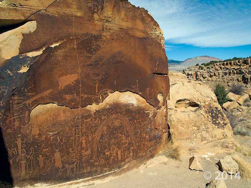
Petroglyphs carved into Ferron Sandstone, Rochester Panel Rock Art Site, Emery County. Rochester Panel Rock Art Site, Emery County, Utah Photographer: Michael Vanden Berg; © 2014

POTD 6-23-15 Petroglyph Rochester Art Panel

Rochester Panel Rock Art Site, Emery County, Utah
Photographer: Michael Vanden Berg; © 2014

Petroglyphs carved into Ferron Sandstone, Rochester Panel Rock Art Site, Emery County.

good4utah.com

Good 4 Utah’s Adam Carroll visited Red Fleet State Park, just seven miles north of Vernal in Uintah County.
Called a “mini Lake Powell” by locals, the park’s lake winds through red cliffs, similar to those found at Lake Powell.
Many people don’t go for just the lake. People can hike, swim or canoe over to 200 million year old dinosaur tracks.
Check out the report above to learn more about the dino tracks at the park.

READ MORE

Banded white marble and quartz augen (eyeshaped crystals) in gray argillite, Notch Peak, Millard County. Photographer: Mark Milligan; © 2014

POTD 6-16-15 Notch Peak Mineral Rock Argillite

Notch Peak, Millard County, Utah
Photographer: Mark Milligan; © 2014

Banded white marble and quartz augen (eyeshaped crystals) in gray argillite, Notch Peak, Millard County.

fox13now.com

Utah is one of the best places to find and study dinosaur fossils. In fact, dinosaur fossils are so abundant here it had many scientists wondering, “Why Utah?”

READ MORE

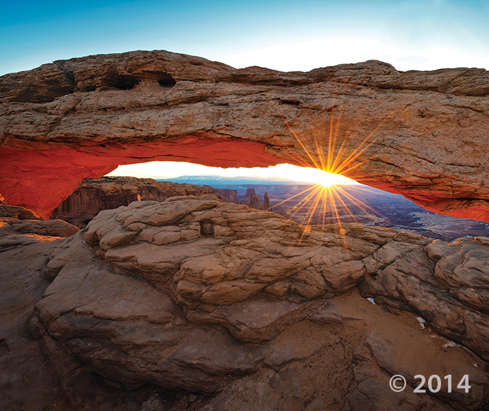
Mesa Arch, in the Island in the Sky District of Canyonlands National Park, formed as surface water pooled and eventually eroded through bedrock at the mesa’s edge. As the sun rises, its rays reflect off the 800-foot-high cliff of Jurassic-age sedimentary rock below the arch, bathing the bottom of the arch in an orange glow. Canyonlands National Park, San Juan County, Utah Photographer: Gregg Beukelman; © 2014

We woke up on the right side of the bedrock today!

POTD 6-9-15 Mesa Arch Canyonlands

Canyonlands National Park, San Juan County, Utah
Photographer: Gregg Beukelman; © 2014

Mesa Arch, in the Island in the Sky District of Canyonlands National Park, formed as surface water pooled and eventually eroded through bedrock at the mesa’s edge. As the sun rises, its rays reflect off the 800-foot-high cliff of Jurassic-age sedimentary rock below the arch, bathing the bottom of the arch in an orange glow.