

eastern Uinta Basin, Uintah County, Utah
Photographer: Michael Vanden Berg; © 2014
Algal stromatolites from the Green River Formation, eastern Uinta Basin, Uintah County.
eastern Uinta Basin, Uintah County, Utah
Photographer: Michael Vanden Berg; © 2014
Algal stromatolites from the Green River Formation, eastern Uinta Basin, Uintah County.
A sad event after a group of people fell victim to a powerful flash flood in southern Utah. Heavy rains in Washington County swept a road away, taking their cars along with it.
As always, please exercise the utmost caution around flash floods, and areas prone to flooding after any amount of rain fall.
sltrib.com
Eight people had died and five remained missing Tuesday morning, the day after an SUV and a van were washed off a road during a flash flood in this polygamous Utah-Arizona border community.

Here are a few more great articles highlighting the work some of our geologists have done towards recent earthquake research in the Salt Lake Valley:
kutv.com
Utah’s seismic scientists are sounding a warning about impending earthquakes in Utah. They say Utah is not prepared for a major earthquake even though science tells us it is when, not if, one will hit the Wasatch front.
fox13now.com
Experts say the state of Utah is not prepared for a big earthquake, and seismologists at the Earthquake Research Institute predict if a 7.0-magnitude quake hit the Wasatch Fault Line it would cost the state about $33 billion in economic losses.
good4utah.com
A new study says Utah is not ready for a major earthquake.

Take a quick minute today on your afternoon break to think about earthquake preparedness. What have you done around your home to help relieve potential damage from a large earthquake? Have you talked to your family and friends, do you have an action plan if an earthquake occurs?
A team of geologists, including some of our very own Utah Geological Survey geologists, have been studying the Taylorsville-West Valley City fault over the last couple of weeks. They hope to gain a better understanding of the fault’s ability to produce large earthquakes, and if that fault tends to rupture with or without the Wasatch Fault. Below are a couple of articles outlining all of their hard work and findings!
deseretnews.com
A team of geologists has dug a 150-foot trench by the Salt Lake City International Airport to study the Taylorsville-West Valley City fault, and its rock samples will help scientists forecast when the next major earthquake could erupt along the Wasatch fault.
ksl.com
A team of geologists has dug a 150-foot trench by the Salt Lake City International Airport to study the Taylorsville-West Valley City fault, and its rock samples will help scientists forecast when the next major earthquake could erupt along the Wasatch fault.


Mount Superior, Salt Lake County, Utah
Photographer: Mike Hylland; © 2014
Tilted and folded Precambrian-age strata on Mount Superior (11,132 feet).
People hiking in Provo Canyon were narrowly missed by a rockfall Monday morning. Very fortunately, no one was seriously injured.
ksl.com
A large rock slide took place in Provo Canyon Monday, narrowly missing several bystanders and leaving rubble across a popular trail.
sltrib.com
Another major land speed event at the Bonneville Salt Flats has been canceled, putting the entire 2015 season in doubt.

Another weekend already?? Well we’re not complaining! Who’s got plans to get out into Utah geology this weekend?
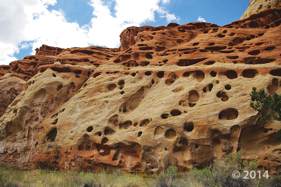
Capitol Reef National Park, Wayne County, Utah
Photographer: Adam McKean
Erosion pockets in Wingate Sandstone, Cohab Canyon, Capitol Reef National Park, Wayne County.
sltrib.com
In a community struggling with a depleted aquifer and land subsidence, the Central Iron County Water Conservancy District is banking on a 50-mile, $150 million pipeline to ease the area’s water shortage.
![]()
The Utah Geological Survey (UGS) is a division of the Utah Department of Natural Resources. Several specialized programs comprise the UGS: Data Management, Energy & Minerals, Geologic Hazards, Geologic Information & Outreach, Geologic Mapping, Groundwater & Wetlands, and Paleontology.
