Tag Archive for: UGS

C-119 Insert

By: Rebekah E. Wood and Thomas C. Chidsey, Jr.

This CD contains an easily viewable 1:700,000-scale map in PDF format of Utah’s oil, gas, and CO₂ fields (past and present); oil gas and CO₂ pipelines with operators; field designations; names and ages of the reservoir rocks; oil refineries and natural gas processing plants; park boundaries and other geographical attributes; and some surficial geologic features. This map is to be used for a general overview and reference for hydrocarbon resources, production, transportation, and processing in Utah. Also included are geographic information system (GIS) files in ESRI file geodatabase and shapefile formats. The latest version of Adobe Reader is required to view the PDF file.

GET IT HERE

See our news release for this publication HERE

OFR-639 Insert

By: Steven Schamel

The Green River Formation in the Uinta Basin has may characteristics typical of an ideal shale oil resource play. It is a world-class oil-prone source rock. In nearly all parts of the basin there are many thousands of net feet of Type-l and Type-ll kerogen-rich calcareous mudstones, many intervals of which have average total organic carbon (TOC) of 5-10% or greater. In the north-central and western parts of the basin a substantial part of the formation is in the oil-generative window. Furthermore, organic maturation simulations done in this study using PRA BasinView-3D™ indicates early entry into the oil-generative window. In the northwest parts of the basin the lower Green River Formation was generating oil even before the end of the Eocene and slowing of sediment accumulation in the basin. The Green River Formation is unquestionably a superb petroleum system responsible for very large cumulative production of oil and associated natural gas, and an even larger potential oil sand resource. This DVD contains a 65-page report.

GET IT HERE

MP 15-4 Insert Hydrocarbon Chainman Shale

By: S. Robert Bereskin, John D. McLennan, Thomas C. Chidsey, Jr., and Peter J. Nielsen

The Mississippian Chainman Shale represents a potential target for untapped oil and gas resources in western Utah and eastern Nevada. This study focuses on the lithologic, facies, petrographic, petrophysical, and geochemical characteristics of a 500-meter-thick Chainman stratigraphic section exposed in the central Confusion Range of western Millard County, Utah. A hypothetical resources assessment, which can be used for the Chainman regionally, was conducted based on the surface samples’ attributes from the study area. Hypothetical undiscovered hydrocarbons on 80-acre spacing are estimated at 270,000 barrels of oil and 1.5 billion cubic feet of gas per well.

GET IT HERE

See our news release for this publication HERE

C-119 Insert

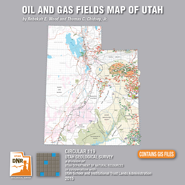
Utah is an important source of crude oil and natural gas, and is currently ranked 11th in United States production. Driven by a decadal long increase in Utah’s oil and gas production, the Utah Geological Survey (UGS) recently released an updated Oil and Gas Fields Map of Utah that shows where most drilling activity has occurred, namely within the Uinta and Paradox Basins in eastern and southeastern Utah, respectively.

This updated map displays Utah’s oil, gas, and carbon dioxide reservoirs; major pipelines; and gas storage fields. In addition to easily identifying areas of current production and potential exploration, the map also shows areas that will not be developed such as national parks and monuments, recreation areas, historic sites, and rock units not expected to contain oil and gas resources. It is beneficial for geologists, engineers, landowners and other stakeholders, as well as state, federal, and county government officials.

The UGS and State of Utah School and Institutional Trust Lands Administration funded this map with the intent to provide an up-to-date quick reference for Utah’s oil and gas resources, production, transportation, and processing. The map, UGS Circular 119, is available for purchase on CD with GIS files, or as a print-on-demand map at the Utah Department of Natural Resources Map and Bookstore, 1-888-UTAHMAP, http://www.mapstore.utah.gov/.

For more information about this map, please contact Rebekah Wood at rwood@utah.gov or 801-537-3378.


Media Contact
Nathan Schwebach
801-538-7303
nathanschwebach@utah.gov

MP 15-4 Insert Hydrocarbon Chainman Shale

A recently released study by the Utah Geological Survey (UGS), reveals untapped potential oil and gas resources in western Utah and eastern Nevada. Petroleum companies conducting oil exploration in the region can use the study to help evaluate oil and gas potential on federal and state lands, and identify possible drilling targets.

Landowners, government regulators and planners, investors, and other stakeholders will also find.

The UGS study focusses on the rock types, paleoenvironments, mechanical properties (critical for oil and gas production), and chemical characteristics of a 1500-foot-thick Chainman Shale outcrop exposed in the central Confusion Range of western Millard County. The Chainman Shale is an organic-rich geologic formation that was deposited in an ancient sea over 350 million years ago. Additionally, based on the surface samples, the study includes a hypothetical assessment of how much oil and gas the Chainman Shale may contain elsewhere in the region.

The report, UGS Miscellaneous Publication 15-4, is available for purchase in digital format (on CD) from the Utah Department of Natural Resources Map and Bookstore, 1-888-UTAHMAP, http://www.mapstore.utah.gov/. A PDF of a summary poster, which was presented during the 2013 American Association of Petroleum Geologists Rocky Mountain Section meeting in Salt Lake City, is also available on the UGS webpage: http://geology.utah.gov/docs/pdf/chainman_poster_aapg-rms2013.pdf.

For more information about the report or the Chainman Shale, contact Thomas C. Chidsey, Jr., at 801-537-3364 or tomchidsey@utah.org.

Media Contact
Nathan Schwebach
801-538-7303
nathanschwebach@utah.gov

The Colorado River loops around the Gooseneck between Dead Horse Point State Park and distant cliffs of the Island in the Sky District of Canyonlands National Park. The river has carved and exposed nearly flat-lying Jurassic to Pennsylvanian-age sedimentary strata of the Colorado Plateau. Dead Horse Point State Park, San Juan County, Utah Photographer: Gregg Beukelman; © 2014

While this photo is a throwback to colder seasons, we cannot deny the stunning #UtahGeology present. This crisp, cold picture is worth a thousand hand warmers—that’s how the saying goes, right?

POTD 5-12-15 Dead Horse Point San juan

Dead Horse Point State Park, San Juan County, Utah
Photographer: Gregg Beukelman; © 2014

The Colorado River loops around the Gooseneck between Dead Horse Point State Park and distant cliffs of the Island in the Sky District of Canyonlands National Park. The river has carved and exposed nearly flat-lying Jurassic to Pennsylvanian-age sedimentary strata of the Colorado Plateau.

Needles District, Canyonlands National Park, San Juan County, Utah Photographer: Adam Hiscock; © 2014

POTD 5-5-15 Needles District Canyonlands

Needles District, Canyonlands National Park, San Juan County, Utah
Photographer: Adam Hiscock; © 2014


The Watchman (6,545 feet), composed of Jurassic-age Navajo Sandstone, stands guard over the southern entrance to Zion Canyon. The canyon has been carved by the North Fork Virgin River, which has eroded downward thousands of feet through the Navajo and underlying Kayenta and Moenave Formations. Zion National Park, Washington County, Utah Photographer: Gregg Beukelman; © 2014

POTD 4-28-15 Zion Watchman

Zion National Park, Washington County, Utah
Photographer: Gregg Beukelman; © 2014

The Watchman (6,545 feet), composed of Jurassic-age Navajo Sandstone, stands guard over the southern entrance to Zion Canyon. The canyon has been carved by the North Fork Virgin River, which has eroded downward thousands of feet through the Navajo and underlying Kayenta and Moenave Formations.

Metate Arch is sculpted by weathering and differential erosion of two sandstone layers along the contact of the Gunsight Butte and overlying Cannonville Members of the Jurassic-age Entrada Sandstone. The arch is about 17 miles southeast of Escalante, just east of the Straight Cliffs. Metate Arch, Devils Garden Outstanding Natural Area, Garfield County, Utah Photographer: Ken Krahulec; © 2014

POTD 4-21-15 Devils Garden Metate Arch

Metate Arch, Devils Garden Outstanding Natural Area, Garfield County, Utah
Photographer: Ken Krahulec; © 2014

Erosion has exposed and sculpted Jurassic-age sedimentary rocks in the southern San Rafael Swell. Near Goblin Valley State Park, towering Wild Horse Butte comprises the Morrison and Summerville Formations (top cliff layers), Curtis Formation (middle slope layer), and Entrada Sandstone (bottom reddish layer). San Rafael Swell, Emery County, Utah Photographer: Taylor Boden; © 2014

POTD 4-14-15, San Rafael Swell

San Rafael Swell, Emery County, Utah
Photographer: Taylor Boden; © 2014

Erosion has exposed and sculpted Jurassic-age sedimentary rocks in the southern San Rafael Swell. Near Goblin Valley State Park, towering Wild Horse Butte comprises the Morrison and Summerville Formations (top cliff layers), Curtis Formation (middle slope layer), and Entrada Sandstone (bottom reddish layer).