Antelope Island, Salt Lake and Davis Counties
Photographer: Andy Cvar © 2017

Evening skies are reflected in Great Salt Lake south of Antelope Island. Otherworldly scenes of wide mudflats are exposed as lake level nears record low elevation.
Antelope Island, Salt Lake and Davis Counties
Photographer: Andy Cvar © 2017
Evening skies are reflected in Great Salt Lake south of Antelope Island. Otherworldly scenes of wide mudflats are exposed as lake level nears record low elevation.
Silver Lake, Wasatch Range
Photographer: Kent Brown © 2017

At 11,749 feet, Mount Timpanogos is the second-highest peak in the Wasatch Range, and is formed of 300 million-year-old limestone and sandstone of the Oquirrh Formation.
Bell Hill Mine, Juab County
Photographer: Mark Milligan © 2017

Vibrant purple fluorite, composed of calcium and fluoride, exposed at the Bell Hill mine in the Spor Mountain mining district. Fluorite is chiefly used as flux for steel manufacturing and in making hydrofluoric acid.
View northeast of Antelope Island, Davis County.
Photographer: Adam Hiscock © 2017

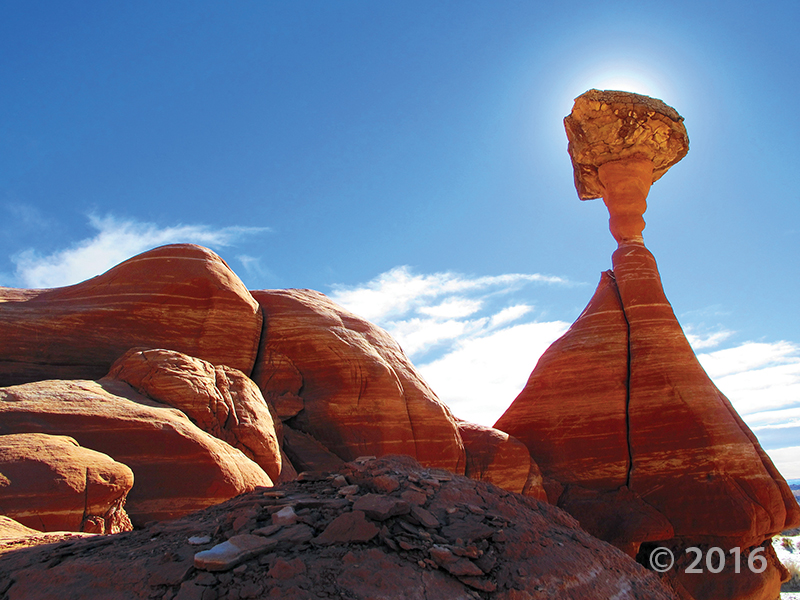
A hard cap rock protects the softer underlying pedestal and neck of this hoodoo in the Jurassic-age Entrada Sandstone, in the Toadstools area of Grand Staircase–Escalante National Monument, Kane County.
Photographer: Mark Milligan © 2016
Tertiary-age Claron Formation erodes into rugged and dramatic canyons near Red Canyon, Garfield County.
Photographer: J. Lucy Jordan © 2016

Hoodoo consisting of Jurassic-age Entrada Sandstone, Devils Garden, Garfield County.
Photographer: Marshall Robinson © 2016.

Eroded granitic rock of the Tertiary-age Emigrant Pass pluton at Devils Playground, Box Elder County.
Photographer: Adam McKean © 2016


Columns of Permian-age Organ Rock Shale seemingly defy gravity in the Land of Standing Rocks in the remote Maze district of Canyonlands National Park, Wayne County.
Photographer: Tyler Knudsen © 2016

![]()
The Utah Geological Survey (UGS) is a division of the Utah Department of Natural Resources. Several specialized programs comprise the UGS: Data Management, Energy & Minerals, Geologic Hazards, Geologic Information & Outreach, Geologic Mapping, Groundwater & Wetlands, and Paleontology.
1594 West North Temple, Suite 3110
Salt Lake City, Utah 84116
801-537-3300 (phone)
801-537-3400 (fax)
Mailing Address:
PO BOX 146100
Salt Lake City, Utah 84114
Monday through Friday,
8 a.m. to 5 p.m.
![]()