Tag Archive for: geology

Talk about leaving no stone unturned. Check out this article on tectonic plates, and how scientists are learning what drives them.

smithsonianmag.com

By setting off explosions and listening for their reverberations deep inside Earth, scientists have taken the equivalent of a CT scan of the base of a tectonic plate. The results show that the base has a thin, slippery layer that may help the plate move across a more viscous layer of rock below—and may explain what drives plate tectonics.

READ MORE

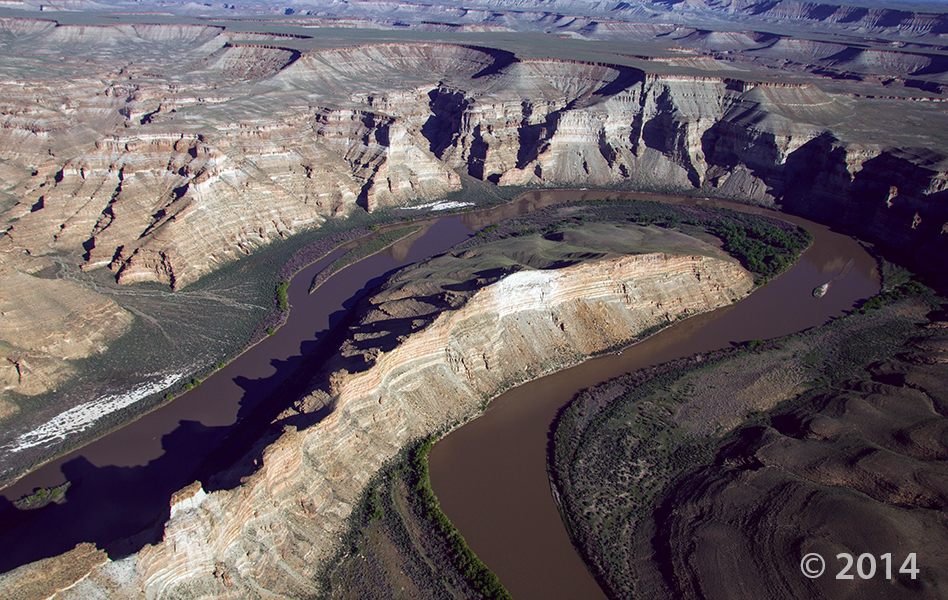
The Green River forms a dramatic “gooseneck” near Sand Wash in upper Desolation Canyon. The river has incised into rocks of the Douglas Creek and Parachute Creek Members of the Tertiary-age Green River Formation, which comprises sediments that accumulated in ancient Lake Uinta. Desolation Canyon, Uintah County, Utah Photographer: Adam Hiscock; © 2014

Hey friends, we’ve finally made way with our new website! Visit geology.utah.gov to see our new look. Though, as most technical endeavors, we’ve encountered some difficulties. Switching the URLs erased our subscription list, and those who subscribed to our “New Blog,” you will have to re-subscribe. We apologize for the inconvenience, but we hope you’ll forgive us when you see this pretty picture of Utah geology.

new-blog

POTD 2-3-15 Desolation Canyon, Uintah County, Green River

Desolation Canyon, Uintah County, Utah
Photographer: Adam Hiscock; © 2014

The Green River forms a dramatic “gooseneck” near Sand Wash in upper Desolation Canyon. The river has incised into rocks of the Douglas Creek and Parachute Creek Members of the Tertiary-age Green River Formation, which comprises sediments that accumulated in ancient Lake Uinta.

ksl.com

New technology is available to Utah information systems that will facilitate faster decision-making and improve management for government and businesses across the state.

READ MORE

Bryce Canyon National Park, Garfield County, Utah Photographer: Danielle Lehle; © 2014

POTD 1-27-15 Bryce Canyon National Park, Garfield County

Bryce Canyon National Park, Garfield County, Utah
Photographer: Danielle Lehle; © 2014

Turret Arch viewed through North Window arch in The Windows Section of Arches National Park. The arches formed as the result of erosion through weak parts of sandstone fins composed of Jurassic-age Dewey Bridge Member of the Carmel Formation and Slick Rock Member of the Entrada Sandstone. Arches National Park, Grand County, Utah Photographer: Gregg Beukelman; © 2014

POTD 1-20-15 Arches National Park, Grand County, Turret Arch

Arches National Park, Grand County, Utah
Photographer: Gregg Beukelman; © 2014

Turret Arch viewed through North Window arch in The Windows Section of Arches National Park. The arches formed as the result of erosion through weak parts of sandstone fins composed of Jurassic-age Dewey Bridge Member of the Carmel Formation and Slick Rock Member of the Entrada Sandstone.

ksl.com

Utah offers many beautiful sights, but sometimes we can be limited by our view.

READ MORE

Goosenecks of the San Juan River from Goosenecks State Park, San Juan County, Utah. Photographer: Marshall Robinson; © 2014

POTD 1-13-15 Goosenecks, San Juan County, State Park

Goosenecks State Park, San Juan County, Utah
Photographer: Marshall Robinson; © 2014

Goosenecks of the San Juan River from Goosenecks State Park, San Juan County.

nationalparkstraveler.com

Baked by time like some multi-layer geologic tort, Canyonlands National Park in southeastern Utah features a landscape cut by canyons, rumpled by upthrusts, dimpled by grabens, and even pockmarked, some believe, by ancient asteroids.

READ MORE

Spot the Rock

StR_21

Hats off to a new year! Let’s celebrate with a new round of “Spot the Rock.” Anyone have an inkling where these rocks are mingling? Post your guesses below, and we’ll reveal the answer next week!

Photo by: Jeremy Harwood

UPDATE: Location Revealed!

Our friends were “spot” on guessing last week’s “Spot the Rock”! This photo shows Mexican Hat, the famous sombrero-shaped rock perched in the Halgaito Formation. The Halgaito and Honaker Trail Formations appear as red and greenish-gray ribbons on the western flank of the Raplee anticline. Farther south on this route, the rock ribbons take on a scalloped appearance that is due to differential erosion of the soft and hard rocks; the softer Halgaito is wearing away from the crest of the anticline.

Save

Late-winter ice still clings to the Colorado River near Big Bend, north of Moab. Boulders of Jurassic-age Wingate Sandstone and Triassic-age Chinle Formation line the banks of the river, eroded from the cliffs and ledges cut by the river as it has incised its channel over millions of years. Colorado River, Grand County, Utah Photographer: Adam Hiscock; © 2014

POTD 1-6-15 Colorado River, Grand County, Utah

Colorado River, Grand County, Utah
Photographer: Adam Hiscock; © 2014

Late-winter ice still clings to the Colorado River near Big Bend, north of Moab. Boulders of Jurassic-age Wingate Sandstone and Triassic-age Chinle Formation line the banks of the river, eroded from the cliffs and ledges cut by the river as it has incised its channel over millions of years.