Spot the Rock

StR_21

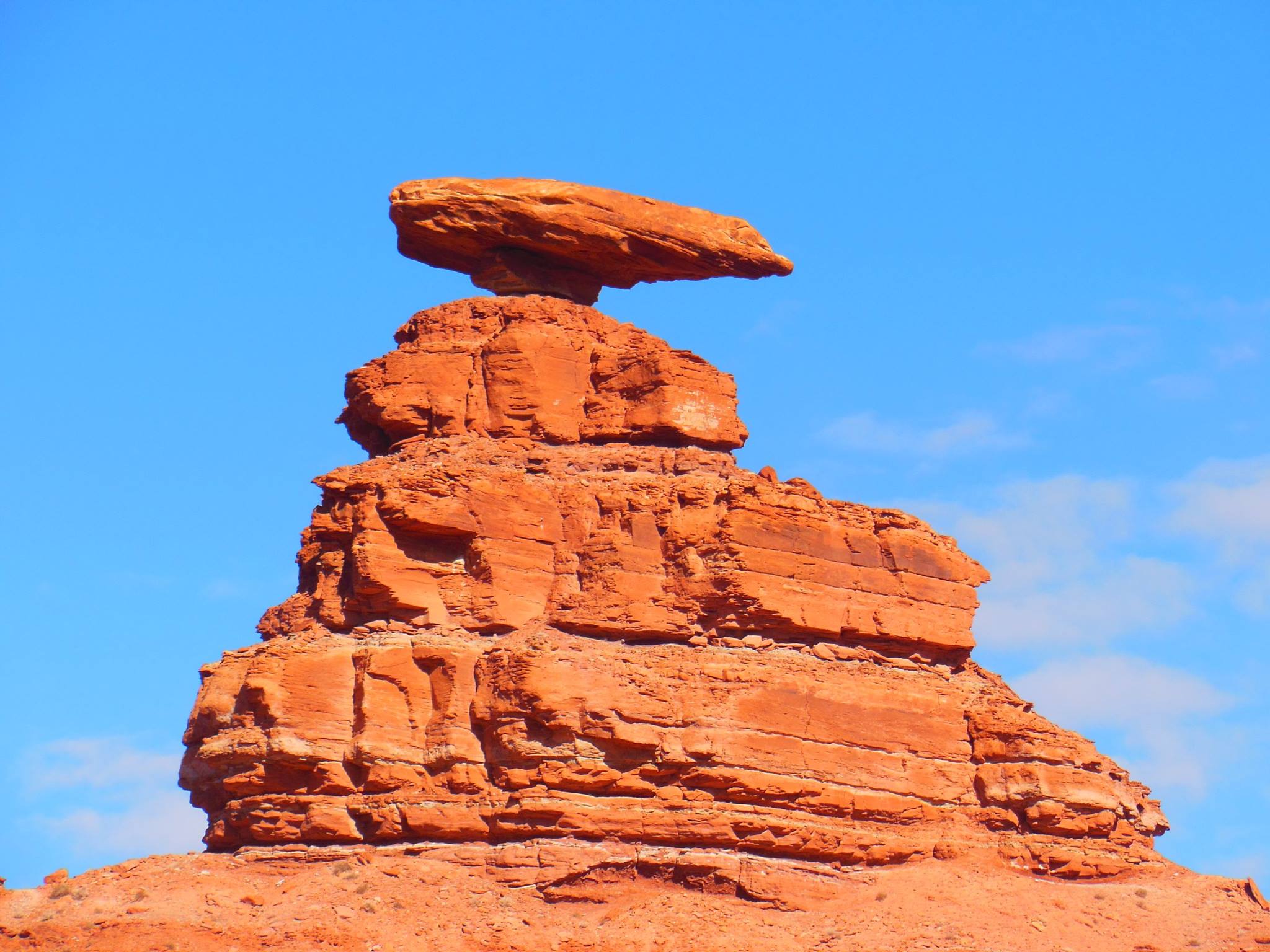
Hats off to a new year! Let’s celebrate with a new round of “Spot the Rock.” Anyone have an inkling where these rocks are mingling? Post your guesses below, and we’ll reveal the answer next week!

Photo by: Jeremy Harwood

UPDATE: Location Revealed!

Our friends were “spot” on guessing last week’s “Spot the Rock”! This photo shows Mexican Hat, the famous sombrero-shaped rock perched in the Halgaito Formation. The Halgaito and Honaker Trail Formations appear as red and greenish-gray ribbons on the western flank of the Raplee anticline. Farther south on this route, the rock ribbons take on a scalloped appearance that is due to differential erosion of the soft and hard rocks; the softer Halgaito is wearing away from the crest of the anticline.

Save

Time for another round of “Spot the Rock”! You might think these photos seem faded or have altered colors, but that’s actually the mineral’s appearance at this site! Can you tell us what mineral is pictured?

For those that know the answer, take the super “Spot the Rock” challenge and tell us the one place in Utah this mineral is found, or what causes the texture in some of the pieces (shown in the close-up photo).

Like us on FACEBOOK or follow us on TWITTER to participate!

UPDATE: Answer revealed!
How many of you knew what mineral was shown in last week’s “Spot the Rock”, or where the spectacular purple mineral is located? It looks like we only had one correct guess—it is fluorite! However, fluorite in this area can also be found in various shades of white, blue, green, buff, yellow, and reddish-brown, dependent upon the presence of various trace elements.The fluorite pictured is located at Bell Hill mine, at the south end of Spor Mountain, Thomas Range, Juab County, Utah.

The textures seen in the close-up picture are fossil corals.

Ore from the Bell Hill mine only contains trace amount Beryllium (0.004% to 0.002%) and no visible bertrandite (bertrandite is a beryllium bearing mineral found at the Brush Wellman mine about a mile to the west).

How about another round of “Spot the Rock”? Who can tell us what mineral the yellow arrow points to in the image?

UPDATE: Answer Revealed

It is SELENITE! For those who guessed, Gypsum, you are technically correct. Though this crystal pictured, Selenite, is a specific type of Gypsum.

This selenite crystal was found in the the mud of a canal bank and U.S. Magnesium near the south shore of Great Salt Lake. Selenite is the name given to the crystalline variety of the mineral gypsum (CaSO4·2H2O). Gypsum is a common evaporative mineral. While gypsum is commonly mined for use in drywall (what interior surface of most building walls), the crystaline form of selenite makes it difficult to process and thus undesirable for use in drywall.

For what are arguably the most amazing crystals ever found, check out Mexico’s Cueva de los Cristales
http://ngm.nationalgeographic.com/2008/11/crystal-giants/shea-text

“Spot the Rock” is back this week with a riddle! What Utah-“rock” is rarer than diamonds, and more valuable than gold?

Check for updates next week to see the answer! Like us on FACEBOOK or follow us on TWITTER to participate!

UPDATE: Answer revealed

Last week’s “Spot the Rock” was definitely one for our rock hounding friends. And everyone guessed right! Red Beryl is found in Utah, is rarer than diamond, and more valuable than gold.

The gemstone has several different names: red beryl, red emerald, or bixbite. Originally, the mineral was named bixbite, but now red beryl is the most accepted designation. Red beryl is estimated to be worth 1,000 times more than gold and is so rare that one red beryl crystal is found for every 150,000 diamonds.

Read more about the mineral HERE

Can anyone “Spot the Rock” this week? This photo shows one of the many textures present in Utah’s geology. Tell us where you think this is!

Like us on FACEBOOK or follow us on TWITTER to participate!

UPDATE: Location Revealed
The Honeycombs, or Honeycomb Hills, is a solitary cluster of hills far out in Utah’s West Desert between the Fish Springs and Deep Creek Ranges. The hills are a product of a violent volcanic eruption some 4.7 million years ago, where forty feet of tuff underlies a 200 million cubic yard dome of topaz-rich rhyolite. The Honeycombs gets its name from the texture of the rock; a recurrent pattern of alcoves, hollows and cubbies, called tafoni, created from a weathering process known as honeycomb, cavernous, or alveolar weathering. This type of weathering is most common to seacoasts and deserts in sandstones and granites on inclined or vertical rock faces. Salt weathering has been implicated in forming tafoni, as well as many other physical, chemical, and biological mechanisms. The weathering of rock into tafoni can occur rapidly, as seen on seawalls built only centuries ago.


Happy Thursday, everybody! This beautiful photo was taken somewhere in Utah. Can anybody “Spot the Rock” and tell us where it is?

Like us on FACEBOOK or follow us on TWITTER to participate!

UPDATE: Location Revealed

Last week’s “Spot the Rock” is of Water Canyon, just north of Hildale, Utah, in Washington County. This image shows the contact between the Navajo Sandstone and the Kayenta formation. Slot canyons in the southwest corner of the state often begin to dramatically widen as the river or stream cuts through the softer units of the Kayenta Formation, undercutting the harder Navajo walls.


We’ve got another Google Maps edition of “Spot the Rock” for you geo friends this week. Each of these photos are from the same location, but at different zoom levels. Can you guess where this is??

Like us on FACEBOOK or follow us on TWITTER to participate!

Who can “Spot the Rock” this week?

Like us on FACEBOOK or follow us on TWITTER to participate!

UPDATE: Location Revealed
Last week’s “Spot the Rock” was another toughie, but we did have one correct guess. Gandy Warm Springs is located half a mile from the Nevada border at the southern base of Spring Mountain (Gandy Mountain) at the western edge of Snake Valley, Utah. Multiple springs come from the sides of the mountain and cascade into a constructed pool made of Cambrian limestone cobbles and boulders. The main spring at Gandy emerges from a cave (Beware Cave) below the soaking pool, discharging an enormous quantity of geothermal water (~81˚F), at nearly 9000 gallons per minute, which flows east as Warm Creek (Gandy Creek).

Great guesses, and keep an eye out for tomorrow’s next “Spot the Rock”!

We’re back with another round of “Spot the Rock”! Where do you think these red rocks reside?

Like us on FACEBOOK or follow us on TWITTER to participate!

UPDATE: Location Revealed

We’re not sure if last week’s “Spot the Rock” was too easy or too hard since we only got one guess (though that one guess was correct…so contrats!) This is a view of part of Sheep Creek Canyon Geological Area, located west of Flaming Gorge National Recreation Area in Daggett County.

The deep red rock layers at left in the photo belong to the 770 to 1,600 million year old Uinta Mountain Group. The ridge forming gray rocks immediately to the right are part of the roughly 330 to 354 million year old Madison Limestone (this cliff is locally called The Palisades). Separating the two units is a 450 million year unconformity and the southwest branch of the Uinta fault zone.

This road-side overlook also provides a somber view of the site of Utah’s most deadly landslide. On June 9, 1965 a debris flow swept through the former Palisade campground (bottom left of photo) destroying the campground and killing seven campers.

For more information, a geologic road guide for the area can be found here:http://www.utahgeology.org/road_logs/uga-29_first_edition/OP_guide/sheepcrk.pdf

Hello, geo friends! We’re going to try something a little different for “Spot the Rock!” today. Thanks to Google Earth, we’ve got an aerial image for you to ponder. Can anyone guess where this is?

UPDATE: Location Revealed

Last week’s “Spot the Rock” featured a Google Earth image of the evaporation ponds at the Intrepid Potash, Inc. ‘solution’ mine in Grand County. These ponds are found roughly 3 miles east and nearly 1,700 feet below Dead Horse Point State Park in San Juan.

‘Potash’ refers to a group of potassium-bearing minerals, the most common of which is sylvite (potassium chloride). Potash is important for its use in fertilizer. Along with other salts, Potash minerals form through the evaporation of saline lakes or oceans. Intrepid produces potash from deeply-buried evaporites formed during the Pennsylvanian Period (~300 million years ago) in a restricted marine basin where seawater was concentrated, precipitated salt, and was subsequently diluted multiple times.

Here is how Intrepid describes their solution mining process:

Water is saturated with salt and the resulting brine is pumped through injection wells into the underground mine workings. The injected brine preferentially dissolves the potash from layers buried between 2,400 and 4,000 feet below the surface. As the brine preferentially dissolves the potassium, the double saturated potassium and salt brine becomes heavier than the salt saturated brine causing it to sink to low points in the mining caverns. Extraction wells are installed at the low points to pump the potash rich brine to the surface, where it is placed into 400 acres of shallow evaporation ponds just southwest of the mine. Blue dye, similar to food coloring, is added to the evaporation pond brines, to aid in absorption of sunlight. There, the water, aided by approximately 300 days of sunshine and an average of just five percent relative humidity evaporates, leaving potash and salt crystals in the pond.https://www.intrepidpotash.com/AboutUs/LocationsOperations/MoabUT.aspx