Utah Potash: Resources, Production, and Exploration
By Bryce T. Tripp
Further Reading
Great Salt Lake Minerals Corporation, 2009, Home page: Online, www.gslminerals.com/home.html.
Hite, R.J., and Cater, F.W., 1972, Pennsylvanian rocks and salt anticlines, Paradox Basin, Utah and Colorado, in Mallory, W.W., editor-in-chief, Geologic atlas of the Rocky Mountain region: Denver, Rocky Mountain Association of Geologists, p. 133–138.
International Plant Nutrition Institute, 2009, Home page: Online,www.ipni.net/.
International Potash Institute, 2009, Home page: Online, www.ipipotash.org/.
Intrepid Potash, Inc., 2009, Mine site locations: Online, www.intrepidpotash.com.
Prud’homme, M., and Krukowski, S.T., 2006, Potash, in Kogel, J.E., Trivedi, N.C., Barker, J.M., and Krukowski, S.T., senior editors,Industrial rocks & minerals, 7th Edition: Littleton, Colorado, Society for Mining, Metallurgy, and Exploration, Inc., p. 723-741.
U.S. Geological Survey, 2009, Minerals information—potash statistics and information: Online, minerals.usgs.gov/minerals/pubs/commodity/potash.
About the Author

Bryce Tripp, Geologist, Utah Geological Survey.
Bryce Tripp has worked with the Utah Geological Survey since October 1979 as an industrial mineral geologist, project manager, section chief, and program manager.
He graduated from the University of Utah, Department of Geology, with a B.S. degree in 1977. Bryce has studied tar sand, zeolite, high-calcium limestone, dimension stone, gypsum, sand and gravel, gilsonite, and potash resources of Utah. He has also worked on long-term projects providing industrial mineral information to state and federal land management agencies.
He is a member of the American Association of Petroleum Geologists and Society for Mining, Metallurgy, and Exploration Inc., and is a member and past president of the Utah Geological Association. Bryce retired from state employment in December 2009.
Introduction
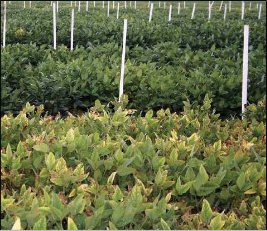
The word potash refers to a group of naturally occurring potassium-bearing minerals, the most common of which is sylvite (potassium chloride). Potash is used to manufacture a variety of products including soap, glass, synthetic rubber, and explosives. Potash is also an essential plant nutrient, and 93% of the potash mined in the world is used as plant fertilizer. The word originates from the historical practice of burning wood to obtain potassium carbonate-bearing ash which was then leached and precipitated in iron pots—“pot ash.” This nutrient is contained in all balanced fertilizer mixes. Bags of fertilizer are labeled with an N-P-K code like 30-10-10; the first number indicates the nitrogen content (N), the second number indicates the phosphorous content (P), and the third number indicates the potassium content (K).
Potassium is found in a variety of salts, is a common element in many rock-forming minerals, and is the 7th-most common constituent of the Earth’s continental crust (about 2%). It is most concentrated and in a water-soluble form in (1) surface and subsurface brines of closed-basin lakes and (2) restricted marine basin (evaporite) deposits. Evaporite deposits worldwide are the most economically important sources of potash. Evaporite minerals precipitated out of concentrated sea water in geologic basins that were partially restricted from the open ocean. Minerals dissolved in sea water precipitate sequentially from solution (during evaporation) based on their solubilities so carbonate minerals precipitate first, then sulfates, and finally chlorides. Sylvite is one of the last salts precipitated; almost all of the water in brine has evaporated before sylvite starts to precipitate.
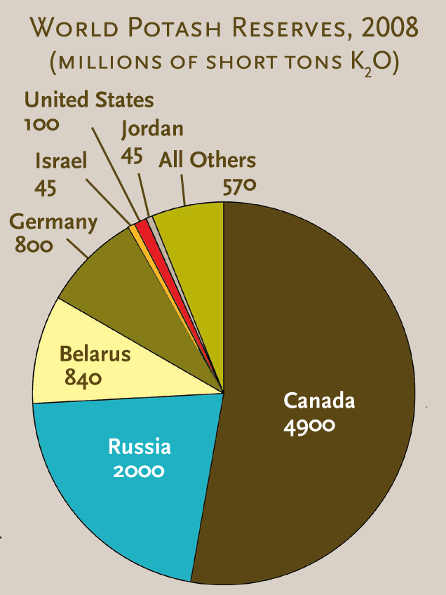
In 2008 the U.S. Geological Survey (USGS) reported that world production of potash was about 40 million tons (K2O equivalent); seven countries produced most of that amount. Canada, Russia, and Belarus are the three largest potash producers. The USGS estimates a world resource of 276 billion tons (K2O), a U.S. resource of 7.7 billion tons (K2O), and a Utah resource of 2.2 billion tons (K2O).
Potash prices have historically been very stable; between 1994 and 2003 the price remained in the range of $146 to $179 per ton. The potash price started rising in 2005 and during 2008 spiked to more than $900 per ton, but by mid-2009 had declined to about $500 per ton. Increased potash prices were caused by an increased standard of living in developing countries (with increased use of chemical fertilizer) and also increased use of fertilizer for ethanol production from corn.
Potash Deposits of Utah
Utah contains substantial potash resources, and potash has been an important mineral product in the state since 1917. Significant quantities of potash are contained in (1) surface brine of Great Salt Lake, (2) subsurface brine of the Great Salt Lake desert, (3) subsurface brine of the Sevier Lake playa, (4) potash beds and associated subsurface brines of the Paradox Basin, and (5) alunite (potassium aluminum sulfate) vein and replacement deposits distributed across southwestern Utah.
Two companies currently produce potash in Utah. Great Salt Lake Minerals Corporation produces more than 400,000 tons of potash (potassium sulfate) each year by solar evaporation of surface brine of the north part of Great Salt Lake at their plant west of Ogden. They are currently trying to obtain permits for 80,000 acres of additional solar evaporation ponds to increase their production. Intrepid Potash, Inc., processes shallow subsurface brines through its solar evaporation ponds and plant at Wendover. Intrepid also solution mines Paradox Basin bedded potash and processes it through their Moab (Cane Creek) solar ponds and mill.
The high potash prices of the past few years have encouraged a flurry of potash exploration and development worldwide, including in Utah. The Paradox Basin has received more interest than other Utah potash resources because it is the largest resource with the most opportunities for new developments.
Paradox Basin Potash
Structure and Stratigraphy
The Paradox Basin bedded potash is contained in the northwest-trending Paradox Basin of Pennsylvanian to Permian age (about 300 million years ago). The Paradox Basin is bounded on the northeast by the Uncompahgre uplift, an uplifted fault block of the Ancestral Rockies. As the Uncompahgre began to rise in Pennsylvanian time, the adjacent Paradox Basin began to subside with the deepest part of the basin adjacent to the Uncompahgre. Salt was deposited in this basin during Pennsylvanian time. A combination of variable salt thickness and salt flowage after burial warped the salt into a series of northwest-trending salt anticlines where the salt is thickened (and often folded and faulted), separated by synclines where the salt is dramatically thinned.
As the Paradox Basin began subsiding, a few hundred feet of predominantly carbonate sediments were deposited as the Pennsylvanian Pinkerton Trail Formation of the Hermosa Group. The basin then became partially restricted from the open sea and as much as 5000 feet of predominantly evaporite sediments (gypsum, halite, potash, and magnesium salts) were deposited as the Paradox Formation of the Hermosa Group. Fluctuations in sea level, and probably in basin subsidence rates, resulted in deposition of 29 rhythmically bedded evaporite cycles; in 18 of the cycles, evaporation proceeded to the point of potash deposition. The salt cycles in the Paradox Formation are often laterally continuous and can be traced, through interpretation of well logs, in the subsurface for tens of miles. The depositional center of the basin shifted over time and the basin floor had varied topography, so not all 29 salt cycles are stacked vertically at any one point in the basin. In the 1960s, Robert Hite (with the USGS) devised a stratigraphic framework for the salt cycles, numbering them from 1 (shallowest) to 29 (deepest) and correlated them across the Paradox Basin. Intrepid Potash, Inc., solution mines the potash of salt cycles 5 and 9 at its Moab mine.
Potash Resource
The salt-bearing zone in the Paradox Basin is about 4000 feet thick and is composed of 10 percent potash beds, 25 percent shale beds (with anhydrite and dolomite), and 65 percent halite beds. Usually eight to 10 potash zones underlie the potash resource areas of the basin and have an aggregate thickness ranging from 220 to 460 feet. In 1965 the U.S. Bureau of Mines estimated the Paradox Basin known potash reserves to be 254 million tons (K2O equivalent) with an inferred reserve of 164 million tons (K2O equivalent). This estimate was based on underground mining of potash beds greater than 4 feet thick, containing more than 14 percent K2O content, and at depths less than 4000 feet. Due to potash deposit complexity, safety issues with underground mining in the Paradox Basin, and improvements in horizontal drilling technology, any future development will likely be by solution mining. Solution mining through drill holes may make potash from beds as deep as 9000 feet recoverable, greatly expanding the potash resource. Some of the oil and gas wells drilled between 1965 and the present penetrated the potash zone; this additional information would probably increase the U.S. Bureau of Mines potash reserve estimates listed above.
Future Development
The Utah School and Institutional Trust Lands Administration and the U.S. Bureau of Land Management (BLM) have met with many companies about exploration and leasing of land in the Paradox Basin. However, there are a few hurdles to new development: (1) the BLM needs to re-examine their Known Potash Leasing Area boundaries before granting new leases, (2) the recent world credit crisis has made funding for new developments difficult to obtain, and (3) the price for potash has declined from its peak at the end of 2008. Even with these hurdles, development of new solution mines in the Paradox Basin seems possible if potash prices remain at their relatively high level or increase.
Survey Notes, v. 42 no. 1, January 2010


