The Hydrogeology and Ecology of the Matheson Wetlands Preserve: A Connected Story
by Kathryn Ladig, Rebecca Molinari, Kayla Smith, and Trevor H. Schlossnagle
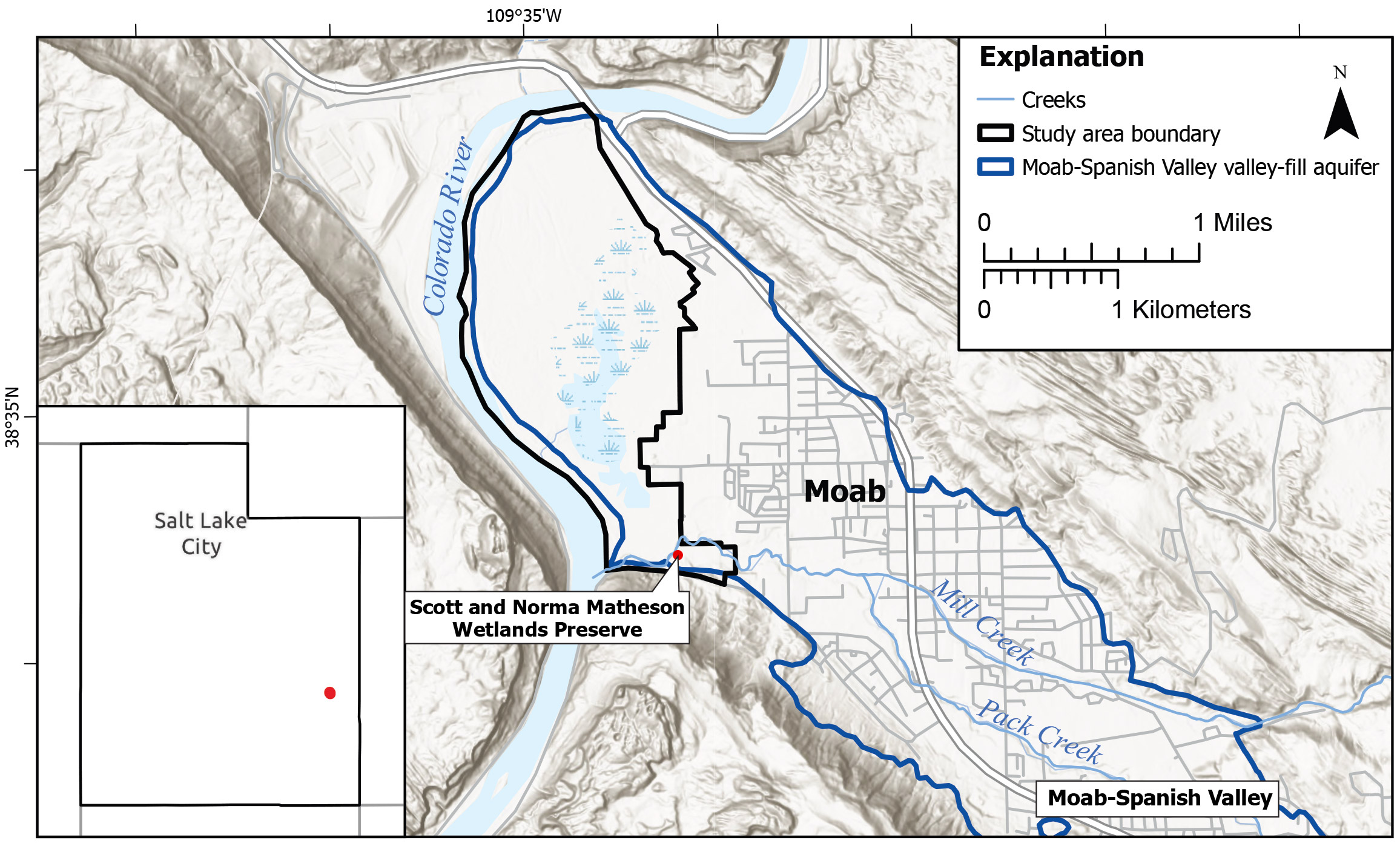
The Moab-Spanish Valley alluvial aquifer, the area where the Glen Canyon Group is absent in the subsurface, and the boundaries of the study area.
The Scott and Norma Matheson Wetlands Preserve (“the Preserve”) is an 894-acre wetland adjacent to the Colorado River, bordering the western edge of Moab, Utah. The Preserve provides habitat to more than 200 species of wildlife and is a popular local destination for hiking, birding, and hunting. It is a sensitive environment that could be negatively impacted by upgradient water consumption and possible upwelling of a brine layer that underlies the fresh water of the Moab-Spanish valley-fill aquifer (VFA) within the boundaries of the Preserve. To address these concerns, we investigated how water flows into and through the Preserve, whether vegetation patterns are changing, and if the brine layer location is changing.
To assess how much water flows into and out of the Preserve, we calculated a water budget (the sum of hydrologic contributions and losses) using field measurements, remote sensing, and the U.S. Geological Survey (USGS) Soil-Water Balance Model, version 2. We found that just over 1000 acre-feet of water passes through the Preserve annually. This small volume of water is vulnerable to water diversion and usage upstream (south and east) of the Preserve in Moab-Spanish Valley.

The Scott and Norma Matheson Wetlands Preserve (“the Preserve”) is an 894-acre wetland adjacent to the Colorado River, bordering the western edge of Moab, Utah.
Our study showed that flood events provide crucial water during the start of the growing season. However, these events are short-lived, leaving vegetation reliant on precipitation, groundwater, and springs through much of the growing season.
We used a dye-tracer test to track how water moves from springs on the east side of Highway 191 to the Preserve. We found that spring water is essential to sustain the health of the wetlands on the east margin of the Preserve, particularly as groundwater levels drop throughout the summer. Water rights allow this spring water to be allocated to a dredged pond in the Preserve or used by landowners and the City of Moab, potentially cutting off the surface water supply from the springs to the eastern part of the Preserve.
Remote sensing analyses on datasets collected from 1993 to 2023 show that surface water extent and frequency of inundation have decreased since 1993, leading to changes in vegetation communities. The western Preserve has had an increase in bare ground and annual species, and a decrease in woody vegetation. These changes are driven in part by fire, tamarisk beetle introduction, mechanical tamarisk removal efforts, and invasion by annual plants, but also may be affected by changes in hydrology and salinity. Normalized Difference Vegetation Index (NDVI) levels, a measure of greenness and proxy for vegetation health, have declined and plant communities on the western edge of the marsh have changed over the past 10 years, likely driven by changes in groundwater levels and spring water use. Vegetation changes in the Preserve are shifting from herbaceous vegetation to invasive annuals and problematic perennials, such as reed canary grass and knapweed. Salinity impacts from the underlying shallow brine layer may further decrease vegetation vigor and contribute to the observed trends.
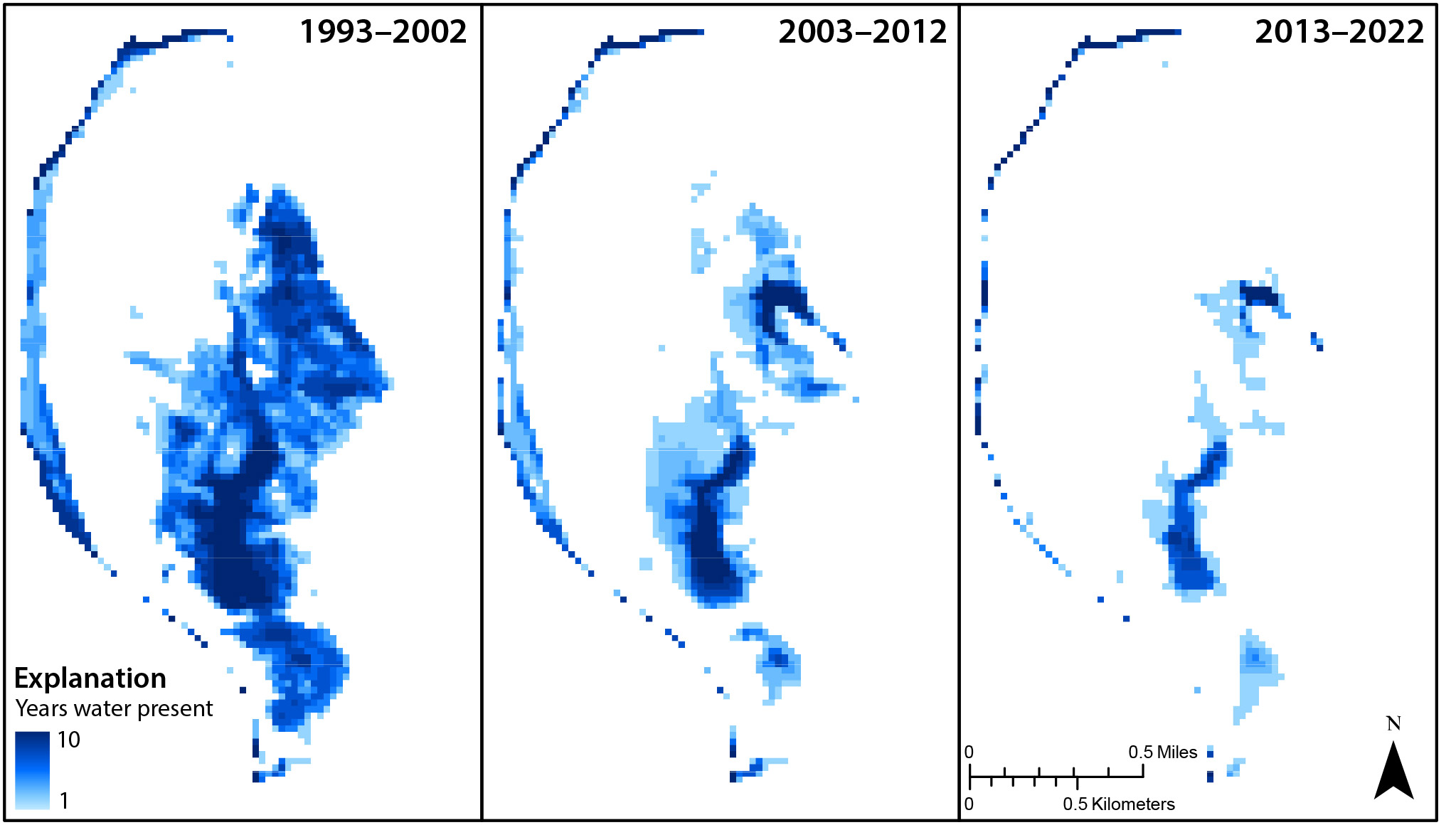
The number of years that surface water was present in each decade according to modeled median May through June surface water extent.
We collected water level measurements from monitoring wells throughout the study area that allowed us to make 22 potentiometric-surface maps, which represent the groundwater surface in the VFA at the time data was collected. These maps indicate that groundwater flows generally from east to west across the Preserve, toward the Colorado River. Lower horizontal hydraulic gradients are common in the spring and higher gradients are common in the fall.
We also constructed potentiometric-surface maps for the brine layer. These maps show decreasing hydraulic head both north and south, originating from a divide near the midpoint of the Preserve. However, the brine may not be flowing and may instead be trapped under the freshwater layer, its location dependent on the elevation of the salt-rich Paradox Formation caprock and overlying freshwater head. We found that VFA groundwater levels move in step with the Colorado River flow (i.e., higher river flow corresponds to higher groundwater levels), except for water levels in wells near the southeast margin of the Preserve, which are highest prior to the peak Colorado River stage, showing the importance of groundwater inflow in these areas.
To constrain the location and origin of the brine, we used transient electromagnetic (TEM) surveys and electromagnetic-induction (EMI) logging, both of which measure electrical conductivity of the subsurface, as well as groundwater chemistry analyses. These methods show that the brine is deepest in the southeast region and shallowest in the northwest region of the Preserve, moving from deep to shallow near the midpoint of the Preserve. Near this midpoint, the potentiometric surface maps show a shallow brine divide, the vertical gradient is upward, and the vegetation community changes. These observations indicate that either the brine is moving upward in this area because of a zone of increased hydraulic conductivity or because the Paradox Formation is closer to the land surface here than it is to the south.

Annotated TEM pseudo 2D cross section from May 2023 describing the location of the brine through the interpreted differences in resistivity.
Chemistry analyses indicate that the brine is most chemically similar to water produced from the Paradox Formation where the brine transitions from deep to shallow and where the vertical hydraulic gradient is most strongly upward. The brine is also more chemically similar to the Paradox Formation with increasing depth. In the southern part of the Preserve, data indicate mixing between Paradox Formation waters and VFA fresh water.

A cross section depiction of groundwater flow and how it changes during low and high groundwater conditions. The green lines represent conditions during low Colorado River flows and low groundwater levels. The blue lines represent conditions when Colorado River flows and groundwater levels are high. The solid lines are the water table and the dashed lines are the approximate brine surface. The blue arrows indicate the change from low groundwater conditions to high groundwater conditions.
We observed, in general, that freshwater head and salinity have a direct relationship in wells close to the river and an indirect relationship in wells farther from the river. We explain the varied response of conductivity to hydraulic head by two dynamics. We infer that sediments near the Colorado River contain interstitial salts that dissolve as groundwater levels rise, causing greater salinity in wells near the river. Salinity decreases as groundwater levels decline and the salts precipitate and are deposited out of solution. Meanwhile, groundwater in the more central part of the Preserve responds like groundwater in an unconfined coastal aquifer that has passive saline-water encroachment. In this case, a decrease in the freshwater pressure head of the unconfined VFA results in the brine water shifting farther underneath the fresh water until it reaches a new equilibrium. Conversely, an increase in freshwater pressure head would shift the brine back toward the river, analogous to the coast in an unconfined coastal aquifer.
The results of our study show that a limited volume of water supports the Preserve’s wetland ecosystem. Whether or not the brine rises toward the surface, 30-year trends indicate that reduced water availability has already altered the plant communities that are habitat for species such as migratory birds and the razorback sucker fish, a Utah Species of Greatest Conservation Need. Continued monitoring of the hydrology and ecology of the Preserve will help guide management decisions of this sensitive environment.
ABOUT THE AUTHORS
Kathryn Ladig
is a Project Geologist with the UGS Groundwater & Wetlands Program. Her current projects include studying evapotranspiration through eddy covariance and water budget analyses.
Rebecca Molinari
is a GIS Analyst with the Groundwater & Wetlands Program. Her work focuses on wetland mapping and analyzing spatiotemporal trends of vegetation and surface water across Utah.

Kayla Smith
is a Project Geologist with the Energy & Minerals program. Kayla works primarily with the geophysics team for subsurface analysis in geothermal and groundwater research.
Trevor Schlossnagle
is a Project Geologist with the Groundwater & Wetlands Program. Trevor’s work with UGS has focused on applying geochemistry to groundwater issues, including water budgets, hydrogeologic characterization, and monitoring hydrologic effects of watershed restoration projects.


