The Curious Spring Creek Road Landslide
By Ben Erickson
About the Author
Ben Erickson

Ben Erickson is a Project Geologist in the Geologic Hazards Program who joined the Utah Geological Survey in 2011. He is a Utah native and has a B.S. in Earth Science from Utah Valley University and a M.S. degree in Geological Engineering from the University of Utah. Ben works to share knowledge of geologic hazards through mapping and working with communities. His role in emergency response ranges from logging digital data to explaining geological hazard conditions to local communities, civic leaders, and the media.
The Utah Geological Survey (UGS) Geologic Hazards Program investigates and researches landslides and other geologic hazards in Utah. Our applied research includes analyzing landslide behavior and developing models that can be used to determine future landslide activity to assist at-risk communities. Through research of previous landslides we know the general factors affecting landslide dynamics in Utah. These factors include the season, the type of rock or soil, seasonal snowpack and runoff, and land modification. These factors typically allow a geologist to anticipate landslide behavior, but in the case of the Spring Creek Road landslide in northern Utah, there was little indication of what was to come.
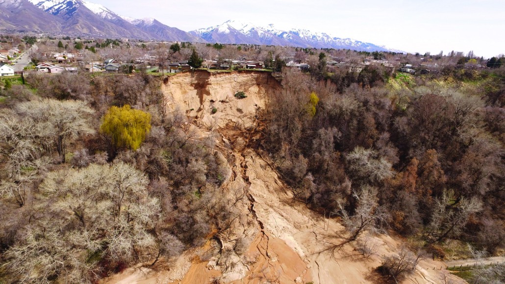
Located 1000 feet east of the Riverdale City offices, the Spring Creek Road landslide, a reactivation of a pre existing landslide, started moving on November 19, 2017. The landslide reactivated on a steep, sandy bluff formed by the Weber River cutting down into the sediments of ancient Lake Bonneville. Several horse pastures are present at the base of the bluff, one of which was severely impacted by the landslide. The pasture owners were present and vividly recount the event: “fast and loud, snapping trees on its way down.” The landslide quickly flowed and covered Spring Creek Road, narrowly missing buildings and machinery.
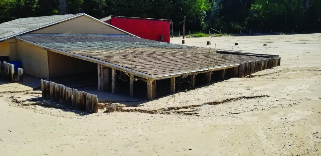
The pasture, which was a Christmas tree staging area at the time, was threatened by continued landsliding and sediment buildup. The landslide cut off access to a home on Spring Creek Road and stopped 120 feet short of a five-track Union Pacific rail yard. The quickly moving landslide and long runout was due, primarily, to abundant= groundwater, which caused it to flow out over 250 feet from the base of the bluff, classifying the landslide as a rapid earthflow. The slide continued to flow in subsequent events for several months, but activity slowed through the summer of 2018.
When it first reactivated, the landslide was about 620 feet long and 160 feet wide. Homes at the top of the bluff were deemed unsafe as the slide slowly carved away at the backyards upslope. Riverdale City issued mandatory evacuation orders for three homes and a voluntary evacuation order for one. As the landslide headscarp continued to recede upslope, all four houses were permanently evacuated.
Following initial landslide movement, water flowing from springs near the base of the cliff face continued to erode the lower deposit to form a smooth alluvial fan. In addition, the steep headscarp was being undercut by spring water flow carrying sediment away and causing further landslide activity, driving the cliff face closer to the evacuated homes, and preventing the slope from grading into a less steep, more stable surface. Flow from the springs also created a stream channel through the pasture and continues to periodically flood the area. The stream channel changes course as large headscarp blocks fall into the deposit. The unpredictable stream channel location has prevented the pasture owners from directing the water away from their structures, resulting in sediment deposition in and around their pasture and buildings that ranges from about 5 feet thick around the buildings to 10–15 feet thick near the base of the bluff. The Union Pacific Railroad added 4 feet of fill on their access road between their tracks and the landslide toe, preventing inundation of the tracks. At the end of summer 2018, the landslide deposit enlarged to about 690 feet long and 260 feet wide, and the headscarp widened 100 feet to the north and south and moved 70 feet toward the homes, undercutting a garage.
At first, the Spring Creek Road landslide did not appear to have any of the indicators typically observed in Utah landslides. The rapid landslide movement occurred in late November, a time when little surface water or precipitation is typically available to influence groundwater levels. The landslide impacted a well-established, 60-year-old residential development that had no recent modifications made to the bluff. The slide continued to enlarge at about the same rate for several months after initial movement. These factors seem to indicate an unusual landslide behavior; however, with further investigation, the behavior became better understood. The closer look started with the bluff.
The bluff is composed of layers of impermeable clay at the base overlain by sand and silt. The sediments were deposited in ancient Lake Bonneville approximately 12,000 to 24,000 years ago as part of a delta that formed at the mouth of Weber Canyon. The delta was over 200 feet thick at the Spring Creek Road landslide site. After Lake Bonneville receded, the Weber River eroded through the delta carving a bluff-bounded floodplain in which much of Riverdale City now resides.
The bluff is shown on geologic maps as a mass-movement deposit where several prehistoric and historical landslides are identified. Aerial imagery indicates activity of some of these landslides as recently as a few years ago. Imagery from June 17, 2017, shows an approximately 20-foot-wide by 70-foot long area of bare soil on the vegetation-covered steep bluff. The bare soil probably indicates the initial landslide reactivation.
The addition of water to the steep bluff is the key reactivation factor in this landslide’s movement. Water is often the driving force or trigger of a landslide. In Utah, excess water is abundant in springs and creeks during snowpack runoff. This means that spring is an active season for landslides, predominantly during high-snowpack and rapid-runoff years. Summer monsoonal rain can also provide excess water, but storms are localized, short-lived, and generally do not provide enough time and water to saturate and mobilize large landslides like the Spring Creek Road landslide. This landslide reactivated with rapid movement in late fall. Groundwater influence, as opposed to seasonal precipitation, is the critical factor for the Spring Creek Road landslide.
Groundwater slowly travels from the Wasatch Range to Great Salt Lake. To determine local groundwater levels, Riverdale City drilled three observation wells east of the landslide in early spring of 2018. The UGS placed sensors in two of the wells to record water levels periodically throughout the day. In other places, groundwaterlevel spikes related to landscape watering have been linked to landslide activity. At Spring Creek Road, however, the observed groundwater levels slowly declined and there is no indication of a groundwater seasonal increase due to landscape irrigation. A delay in summer landscape watering spikes is possible and could be detected by continued monitoring.
Three of the homes affected by the Spring Creek Road landslide were built in 1960 and one in 1963, decades before formal geologic and geotechnical engineering planning and construction ordinances were adopted in Utah. However, future planning for this area and similar geologic areas needs to take advantage of available resources to reduce the risk associated with this type of landslide and other geologic hazards. The 1988 slope-failure inventory map produced by Weber County and the 2004 geologic map of the Ogden 7.5-minute quadrangle published by the UGS show this landslide is within an area of previously mapped landslides along the bluff. These map resources can help established communities and developers evaluate risk and plan for disasters such as the 2017 landslide.
The UGS continues to study and monitor the Spring Creek Road landslide and provide information and advice to Riverdale City as requested. The active springs at the base of the landslide scarp continue to create a high risk for landslide activity and resulting damage to land and infrastructure.
For more information see:
Survey Notes, v. 51 no. 1, January 2019


