GeoSights: Big and Little Brush Creek “Ice” Caves, Uintah County, Utah
by Mark Milligan
Authors’ Note, July 2023
This article highlights the ice found at the large cavernous openings of Big and Little Brush Creek Caves. Access to the cave mouths can be difficult and is dependent upon current trail conditions and weather. The cave systems that extend beyond the large openings are extremely hazardous and should not be entered. For more information on cave safety and spelunking, contact the National Speleological Society—or a local affiliate such as the Wasatch Grotto.
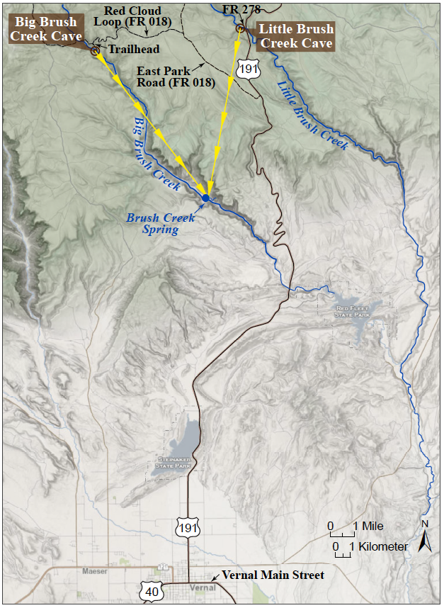
Spaced nearly 5 miles apart, Big and Little Brush Creek Caves (BBCC and LBCC, respectively) are found high on the south slope of the Uinta Mountains, about 17 miles north of Vernal, Utah. Unlike better known caves with mineral formations of stalagmites and stalactites, these caves are filled with spectacular ice crystals and formations that vary seasonally and from year to year depending upon seasonal temperature and precipitation variations.
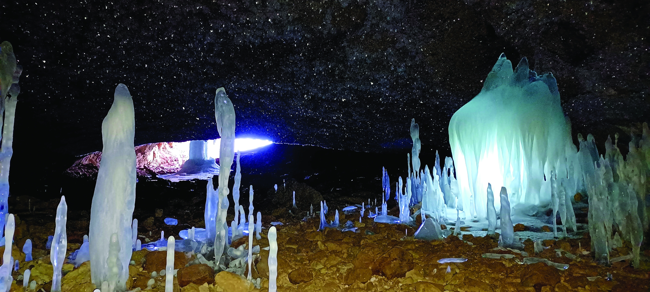
A substantial ice column in the entrance room of BBCC can persist into or throughout summer, and perennial ice is reportedly found a bit deeper in the cave. LBCC contains seasonal ice but no perennial ice; however, it is easier to access in winter, being near U.S. Route 191, which is plowed.
The ability of BBCC to hold ice is due to multiple factors, including:
- High elevation—The cave is located at a chilly 8,160 feet above sea level.
- Cold trap—The entrance lies at the bottom of a dead-end canyon with a disappearing stream, causing dense cold air from higher up the mountain to settle and collect. Furthermore, the cave has no lower exit point so cold air cannot escape through the cave.
- No warming sun—The entrance faces north and is heavily shaded.
- Significant ice volume—When air temperatures drop below freezing, groundwater continues to drip into the cave, creating spectacular ice formations in winter. The larger they grow, the longer they take to melt away.
- Limited airflow—In the northeastern part of the cave, where perennial ice is found, a ridge of bedrock, sediment, collapse material, and ice itself constricts openings and thus airflow, keeping temperatures low during warm weather.
- Limited streamflow—Much of the water that would otherwise flow into the cave and melt ice, is lost to underground plumbing (karst) upstream of the cave.
Both caves are located at the bottom of active though often dry stream channels within the Madison Limestone, which contains multiple caves and sinkholes in the greater area. These caves, like most caves, formed as acidic groundwater dissolved the limestone and carried it away in solution.
WARNING:
Beyond their initial cavernous openings both BBCC and LBCC have extensive cave systems that abound with hazards including vertical drop-offs and areas with bad air (high carbon dioxide levels). Spring snowmelt and/or rain can cause unexpected flooding. Do not explore these cave systems unless you are well prepared and have extensive spelunking experience. For more information on cave safety and spelunking, contact the National Speleological Society—or a local affiliate such as the Wasatch Grotto.
Accessibility and Location:
The caves are accessed via U.S. Route 191, which is plowed and open through winter. However, secondary U.S. Forest Service roads are only open to automobiles when not covered by snow. During the winter the route from U.S. 191 to BBCC is a groomed snowmobile trail that is part of the Uintah Basin Snowmobile Complex. The route to LBCC is a dedicated cross-country ski trail during winter. Furthermore, high creek flow from spring snowmelt can seasonally flood BBCC making it inaccessible. Similarly, LBCC is often flooded in spring and summer. FOR ROAD CLOSURE DATES AND CREEK CONDITIONS, PLEASE CONTACT THE ASHLEY NATIONAL FOREST, VERNAL RANGER DISTRICT, 435-789-1181.

Dye tracer tests by the UGS show that water entering BBCC and LBCC during high streamflow emerges at Brush Creek Spring, which is nearly 6 miles from the caves. Yellow arrowed lines are dye trace flow lines.
How to Get There:
The caves can be found using either GPS navigation or the indicated mileage below. Beginning on U.S. Route 191 at Main Street in Vernal headed north:
Big Brush Creek Cave coordinates—40.697169° N, 109.584026° W
19.7 miles Turn LEFT onto East Park Road (FR 018).
3.3 miles Turn LEFT onto Red Cloud Loop (FR 018).
3.5 miles Trailhead is on the LEFT at a slight gap in the shoulder barrier with a “non-motorized” trail marker. Note: a roadside parking spot is about one-quarter of a mile farther on the road.
0.5 mile HIKE Follow the double track trail for about one-half of a mile. At the fork, go right and then proceed down into the drainage bottom. The final descent is very steep and it may be easier to walk farther up the canyon and double back along the bottom. The cave mouth, which opens onto the creek bed and faces north, is easily spotted from above.
Little Brush Creek Cave coordinates—40.709144° N, 109.500585° W
22.0 miles Turn LEFT onto FR 278.
0.4 miles The cave mouth faces north and can be seen in the drainage bottom to the left. The final descent is very steep and it may be easier to drive farther up the canyon and double back along the bottom.


 The opportunity for Carbon Capture Utilization and Sequestration (CCUS)—sometimes abbreviated to CCS—depends considerably on the type of rock present in the subsurface. (A) CO2 storage can occur by injecting gas deep underground into rock strata deemed unsuitable for other purposes. Modified from imagery provided by Global CCS Institute (https://www.globalccsinstitute.com/resources/ccs-image-library/). (B) A 4-inch-wide slabbed rock core from the Covenant oil field, Sevier County, Utah. The sandstone (buff-colored) is a good reservoir rock due to its porous and often permeable grains. The mudstone (red) is a good geological seal because it has low permeability and prohibits fluid and gas from escaping upwards. The sharp color contrast indicates the boundary between the seal and reservoir rock. The five holes in the rock core are where plugs were drilled into the rock and removed for analysis. (C) and (D) are photomicrographs of Jurassic-age Navajo Sandstone (reservoir rock) from the Covenant oil field that illustrate pore space availability (blue areas) for CO2 storage between quartz grains (white areas). Images B, C, and D modified from Chidsey and others (2020) (https://doi.org/10.34191/ss-167). Note the significant difference in scale from the well (kilometers) to the core (meters) to the rock grain and pore space (millimeters).
 Interbedded coal and sandstone in the Blackhawk Formation (just off SR-6, near Helper). Source : Mike Vanden Berg
 A few of the species from the Jurassic Salad Bar site. A) The reproductive organs of the fern Coniopteris hymenophylloides. B) Partial leaf of the ginkgophyte Sphenobaiera sp. C) Leaf bundles of the ginkgophyte Czekanowskia turneri. D) Partial leaf of the ginkgophyte Ginkgoites sp. E) Partial frond of the fern Coniopteris hymenophylloides. F) Abdominal segments and forewing of the giant water bug-like insect Morrisonnepa jurassica (Lara and others, 2020); abbreviation se = abdominal segment. G) Conchostracans, often called clam shrimp. All scale bars = 1 cm. Photos by Tom Howells, Utah Field House of Natural History State Park Museum.
 The Drum Mountains meteorite at the Smithsonian. Flat surface at top is where the meteorite was cut for sectioning. https://commons.wikimedia.org/wiki/File:Drum_Mountains_meteorite_in_Museum_of_Natural_History.jpg
 Large ice column in the entrance room of BBCC. February 2022.


