COSTS OF GEOLOGIC HAZARDS
Since 1847, approximately 6,075 fatalities from geologic hazards have been documented in Utah, as well as a significantly larger, but undetermined amount of injuries. Radon gas exposure (causing lung cancer) has been Utah’s most deadly geologic hazard, followed by landslide hazards, then flooding hazards.
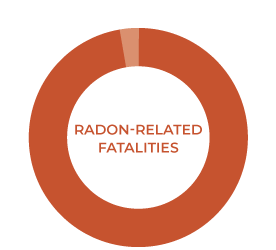
Lung cancer fatalities caused by radon gas are Utah’s most deadly geologic hazard. Radon-related deaths account for 97 percent of all geologic hazard fatalities in Utah.
89.8 percent of landslide hazard fatalities resulted from snow avalanches and 10.2 percent from landslides, rockfalls, and debris flows.
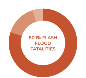
80.1 percent of flooding hazard fatalities resulted from floods and flash floods, 14.9 percent from debris flows, and 5.0 percent from dam or water conveyance structure failures.
Using the economic value of a statistical life of $11.6 million (2016 data), the 6,075 fatalities are valued at $70.5 billion. The estimated economic value of human life is not considered in the hazard economic costs given in the tabbed area below.
In most all cases, it is more cost effective to perform a comprehensive engineering-geology investigation to identify and characterize geologic hazards and implement appropriate mitigation in project design and construction, rather than relying on additional maintenance over the life of the project or to incur costly change orders during construction.
Earthquake Hazards
Although only two fatalities from earthquakes (ground shaking) have occurred in Utah since 1847, scenario modeling of a major (magnitude [M] 7.0) earthquake on the Salt Lake City segment of the Wasatch fault zone predicts 2,000 to 2,500 fatalities, 7,400 to 9,300 life-threatening injuries, 55,400 buildings completely damaged, 21 million tons of debris, and $33.2 billion in estimated short-term, direct economic losses. The short-term financial losses do not include the long-term economic costs that include closed businesses, lower productivity and economic output, and other costs. Sixty-one percent of the total number of buildings in the 12-county area in northern Utah will be moderately damaged or totally destroyed. Such an event will likely take decades to recover from and will be the single most costly geologic hazard event to affect Utah.
Damage from the 2008 Wells, Nevada (population 1,657), earthquake (M 6.0) totaled approximately $10.5 million, with nearly half of the approximately 80 non-residential buildings damaged and 10 severely damaged. The Wells earthquake is an important analog for rural Utah towns and cities, which have similar unreinforced masonry (URM) building stock and fragile economic conditions.
More Data
Known Fatalities from Earthquakes in Utah Since 1850.
Date | Location | Fatalities | Notes | References1 |
3/12/1934 | Hansel Valley fault zone (M6.6) | 2 | Trench collapse (1) and death of sick woman (1). | UUSS |
Total: | 2 |
1 UUSS (University of Utah Seismograph Stations).
Earthquake Scenarios and Damage Estimates
Salt Lake City Segment, Wasatch Fault Zone Magnitude 7.0 Scenario
February 21, 2008 Mw 6.0 Wells, Nevada earthquake
Utah Earthquake Scenarios
Wasatch Front Region Earthquake Probabilities
There is a 57% (greater than 1 in 2 chance) probability of a M6.0 earthquake within the Wasatch Front region in the next 50 years.
Working Group
Landslide Hazards
Landslide hazards have resulted in at least 342 fatalities in Utah since 1850, with 90 percent of those deaths from snow avalanches and 10 percent from landslides, rockfalls, and debris flows. While nearly all the recorded deaths since 1950 have been caused by human-triggered avalanches, many of these events have occurred in developed areas where appropriate mitigation measures should be employed.
Landslides
The 1983 Thistle landslide, Utah’s largest natural (non-mining related) landslide, resulted in direct costs of $200 million, including $81 million in lost revenue by the Denver and Rio Grande Western Railroad (now Union Pacific Railroad). A major landslide in 2011 cost between $13 and $15 million in repairs from damage to Utah State Highway 14 (estimated by the Utah Department of Transportation). The 2014 Parkway Drive landslide in North Salt Lake severely damaged a house and tennis and swim club and threatens other houses and nearby regional natural gas pipelines. Remediation is expected to cost at least $2 million, not including emergency response or homeowner relocation costs. The Springhill landslide in North Salt Lake resulted in demolition of 18 homes since movement began around the late 1990s. Due to ongoing movement and subsequent public safety hazards, the City of North Salt Lake applied for a Federal Emergency Management Agency grant in 2011 to mitigate landslide hazards by purchasing 11 affected homes and demolishing them at a cost of $2.5 million.
More Data
Known Fatalities from Landslides in Utah Since 1850.
Date | Location | Fatalities | Notes | References1 |
3/12/2005 | Kanab Creek, Kanab | 1 | Stream bank collapse | UGS RI 269, p. 17-24 |
7/11/2009 | Logan Bluffs, Logan | 3 | Canal/landslide failure, home destroyed with three occupants2 | UGS, Survey Notes, 2009, v. 41, no. 3, p. 10 |
Total: | 4 |
1 RI (Report of Investigation), UGS (Utah Geological Survey).
2 It is unknown if a landslide initially caused the canal failure or if the canal failure caused the landslide; therefore the three fatalities are included in both the “Landslides” and “Dam and Water Conveyance Structure Failure” categories.
Rockfalls
Rockfalls have caused significant damage to structures and property and resulted in at least 16 deaths in Utah since 1850. Many of these fatalities were recreation-related. Utah’s most recent rockfall-related fatalities were from the December 12, 2013, rockfall in Rockville, Utah, where two people died when numerous large boulders struck their home, destroying two buildings. Seven major rockfalls have been documented in Rockville since 1976.
More Data
Known Fatalities from Rockfall in Utah Since 1850.
Date | Location | Fatalities | Notes | References1 |
4/25/1874 | Hyrum Canyon, Hyrum | 2 | Broken ledge | UGS OFR 514 |
10/20/1892 | Ogden Canyon, near Kilns | 1 | — | UGS OFR 514 |
5/5/1895 | Weber Canyon | 1 | Railroad engineer | UGS OFR 514 |
2/7/1909 | Ruby-Westwater | 1 | Railroad worker, possibly in Colorado | UGS OFR 514 |
7/29/1937 | Price | 2 | Occurred after rain storm | UGS OFR 514 |
1960s-1970s? | Timpanogos Cave National Monument | ? | — | NPS communication |
7/25/1994 | Hanging Rock Picnic Area, American Fork Canyon | 1 | — | USGS OFR 1229 |
1/14/1995 | Big Cottonwood Canyon | 1 | — | UGS RI 228 |
7/29/1995 | Hanging Rock Picnic Area, American Fork Canyon | 1 | — | UGS OFR 373, USGS OFR 1229 |
8/2/1999 | Lake Powell, Goosenecks of San Juan Arm, Glen Canyon National Recreation Area | 1 | Camper struck on head, boulder rolled onto tent | UGS OFR 373, PI 94; NPS Geologic Hazard Events |
10/1/2007 | Lake Powell, Lake Canyon, Glen Canyon National Recreation Area | 2 | Rock slab collapse onto boat from overhanging alcove roof | NPS Geologic Hazard Events; http://www.ksl.com/?nid=148&sid=1897666 |
12/12/2013 | 368 West Main Street, Rockville | 2 | Home destroyed | UGS RI 273 |
Total: | 15 |
1 NPS (National Park Service), OFR (Open-File Report), PI (Public Information series), RI (Report of Investigation), UGS (Utah Geological Survey), USGS (U.S. Geological Survey).
Debris Flows
Debris flows have caused significant damage to structures and property and resulted in at least 15 deaths in Utah since 1847. Damage to 29 homes and two businesses from the September 12, 2002, Santaquin fire-related debris flow totaled about $500,000. As debris flows are both a landslide and flooding hazard, fatalities are included in both hazard categories.
More Data
Known Fatalities from Debris Flows in Utah Since 1850.
Date | Location | Fatalities | Notes | References1 |
8/13/1923 | Farmington Creek, Farmington | 6 | Campers | UGS files |
6/11/1965 | Sheep Creek, Flaming Gorge National Recreation Area | 7 | Campers | UGA Publication 28 |
5/13/1984 | Clear Creek, Carbon County | 1 | Slope above house | UGS files |
5/14/1984 | Middle Fork Canyon, Carr Fork mine, Tooele County | 1 | Dozer operator | UGS files, Brough and others (1987) |
Total: | 15 |
1 UGA (Utah Geological Association), UGS (Utah Geological Survey).
Snow Avalanches
Snow avalanches have resulted in at least 307 fatalities in Utah since 1847, with 192 from avalanches in developed areas and 113 from winter sports-related avalanches. While most of the winter sports-related fatalities were caused by human-triggered avalanches, many occurred near developed areas where appropriate mitigation measures should have been employed to protect the developed areas.
More Data
Known Fatalities from Snow Avalanches in Utah Since 1847.
Date | Location1 | Fatalities | Notes | References2 | |
Sports | Other | ||||
1847-1949 | Various3 | 118 | — | Brough | |
2/13/1885 | Emma mine, Alta | 16 | Covered 3/4th of town | Brough | |
1/1903 | Near Park City | 3 | Miners | Brough | |
1/31/1911 | Alta | 4 | Miners | Brough | |
3/1920 | Canyons around Salt Lake Valley | 9 | Also first few days of April | Brough | |
2/17/1926 | Bingham Canyon | 394 | Homes destroyed | Deseret News | |
1950-1957 | Various | 1 | Brough | ||
3/9/1958 | Snowbasin | 2 | Rescuers | NWS/UAC | |
3/29/1964 | Snowbasin | 1 | Worker | NWS/UAC | |
2/12/1967 | Pharaohs Glen | 2 | Climbers | NWS/UAC | |
2/19/1968 | Rock Canyon | 1 | Hiker | NWS/UAC | |
1/29/1970 | Alta | 1 | In-bounds skier | NWS/UAC | |
1/29/1970 | Park West | 1 | In-bounds skier | NWS/UAC | |
1/6/1976 | Alta | 1 | Out-of-bounds skier | NWS/UAC | |
3/3/1976 | Snowbird | 1 | In-bounds skier | NWS/UAC | |
1/19/1979 | Helper | 1 | Worker | NWS/UAC | |
4/2/1979 | Lake Desolation | 1 | Backcountry skier | NWS/UAC | |
1/11/1980 | Evergreen Ridge | 1 | Out-of-bounds skier | NWS/UAC | |
2/1/1981 | Cardiff | 1 | Hiker | NWS/UAC | |
3/1/1981 | Millcreek | 1 | Backcountry skier | NWS/UAC | |
3/22/1982 | Near Park West | 1 | Backcountry skier | NWS/UAC | |
1/2/1984 | Superior Peak | 1 | Backcountry skier | NWS/UAC | |
2/22/1985 | Powder Mountain | 1 | Backcountry skier | NWS/UAC | |
3/19/1985 | Park City | 1 | In-bounds wet slide | NWS/UAC | |
11/13/1985 | Sunset Peak | 2 | Backcountry skiers | NWS/UAC | |
1/6/1986 | Provo Canyon | 1 | Backcountry skier | NWS/UAC | |
2/17/1986 | BCC | 1 | Backcountry snowboarder | NWS/UAC | |
2/19/1986 | Alta | 1 | In-bounds skier | NWS/UAC | |
11/20/1986 | Sugarloaf, Alta | 1 | Hiker, unopened area | NWS/UAC | |
2/15/1987 | Twin Lakes Reservoir | 1 | Backcountry skier | NWS/UAC | |
11/25/1989 | Tony Grove Lake | 1 | Backcountry skier | NWS/UAC | |
2/12/1992 | Gold Basin, La Sal Mountains | 4 | Backcountry skiers | NWS/UAC | |
4/1/1992 | Mineral Basin, Snowbird | 1 | Backcountry skier | NWS/UAC | |
1/16/1993 | Sundance | 1 | Backcountry skier, closed area | NWS/UAC | |
2/25/1993 | Pinecrest, Emigration Canyon | 1 | Backcountry skier | NWS/UAC | |
4/3/1993 | Wolverine Cirque | 1 | Backcountry skier | NWS/UAC | |
2/18/1994 | 10,420’ Peak, BCC | 1 | Backcountry skier | NWS/UAC | |
11/7/1994 | Snowbird | 1 | Backcountry skier, pre-season | NWS/UAC | |
1/14/1995 | Ben Lomond Peak | 2 | Snowmobilers | NWS/UAC | |
1/23/1995 | Midway | 1 | Resident in roof slide. | NWS/UAC | |
2/12/1995 | Gobblers Knob, BCC | 1 | Backcountry skier | NWS/UAC | |
2/2/1996 | Solitude | 1 | Patroller | NWS/UAC | |
3/27/1996 | Maybird Gulch, LCC | 1 | Backcountry skier | NWS/UAC | |
12/7/1996 | Bountiful Peak | 1 | Snowmobiler | NWS/UAC | |
12/26/1996 | Flagstaff Peak | 1 | Snowmobiler | NWS/UAC | |
1/11/1997 | Logan Peak | 3 | Campers | NWS/UAC | |
1/25/1997 | Provo Canyon | 1 | Climber | NWS/UAC | |
1/17/1998 | Near Coalville | 1 | Snowmobiler | NWS/UAC | |
1/18/1998 | Sanpete County | 1 | Snowmobiler | NWS/UAC | |
2/26/1998 | Near Weber State | 1 | Hiker (possible suicide) | NWS/UAC | |
11/7/1998 | Snowbird | 1 | Snowboarder, pre-season | NWS/UAC | |
1/2/1999 | Wasatch Plateau | 2 | Snowboarders | NWS/UAC | |
1/29/1999 | Mt. Nebo | 1 | Snowmobiler | NWS/UAC | |
2/6/1999 | Little Willow Canyon | 1 | Hiker | NWS/UAC | |
1/11/2000 | Squaretop, Canyons | 2 | Out-of-bounds skiers | NWS/UAC | |
2/27/2001 | Near Canyons | 1 | Out-of-bounds skier | NWS/UAC | |
3/10/2001 | Oakley, Uinta Mountains | 2 | Snowmobilers | NWS/UAC | |
4/28/2001 | Stairs Gulch, BCC | 2 | Climbers | NWS/UAC | |
12/14/2001 | Willard Basin | 1 | Snowmobiler | NWS/UAC | |
1/31/2002 | Windy Ridge, Uinta Mountains | 1 | Backcountry skier | NWS/UAC | |
3/16/2002 | Pioneer Ridge, Brighton | 2 | Out-of-bounds snowboarders | NWS/UAC | |
2/15/2003 | Gobblers Knob, BCC | 1 | Backcountry skier | NWS/UAC | |
12/26/2003 | Aspen Grove, Timpanogos | 3 | Backcountry snowboarders | NWS/UAC | |
2/26/2004 | Empire Canyon, Park City | 1 | Snowshoer | NWS/UAC | |
12/10/2004 | Twin Lakes Pass, SLC | 1 | Backcountry skier | NWS/UAC | |
12/11/2004 | Trout Creek, Strawberry | 1 | Snowmobiler | NWS/UAC | |
Mineral Fork, SLC | 2 | Snowshoers | NWS/UAC | ||
1/8/2005 | Choke Cherry, Mt. Pleasant | 1 | Snowmobiler | NWS/UAC | |
Ephraim Canyon | 1 | Snowboarder | NWS/UAC | ||
1/14/2005 | Dutch Draw, Park City | 1 | Snowboarder | NWS/UAC | |
3/31/2005 | Whiskey Hill | 1 | Snowboarder | NWS/UAC | |
12/31/2005 | Emerald Lake, Timpanogos | 1 | Snowshoer | NWS/UAC | |
3/11/2006 | Taylor Canyon, Ogden | 1 | Snowboarder | NWS/UAC | |
4/3/2006 | Pioneer Ridge, Brighton | 1 | Out-of-bounds snowboarder | NWS/UAC | |
2/17/2007 | Signal Peak | 1 | Snowmobiler | NWS/UAC | |
Tower Mountain | 1 | Snowmobiler | NWS/UAC | ||
2/18/2007 | Hells Canyon, Snowbasin | 1 | Out-of-bounds skier | NWS/UAC | |
2/21/2007 | Gobblers Knob, BCC | 1 | Backcountry skier | NWS/UAC | |
12/23/2007 | Canyons | 1 | Skier | NWS/UAC | |
12/25/2007 | Thousand Peaks | 1 | Snowmobiler | NWS/UAC | |
12/31/2007 | Co-op Creek | 1 | Snowmobiler | NWS/UAC | |
12/14/2008 | Mt. Baldy, Snowbird | 1 | In-bounds skier | NWS/UAC | |
12/24/2008 | Providence Canyon | 2 | Snowmobilers | NWS/UAC | |
12/29/2008 | Windy Ridge-Moffit Basin | 1 | Snowmobiler | NWS/UAC | |
1/24/2010 | Hells Canyon, Snowbasin | 1 | Out-of-bounds skier | NWS/UAC | |
1/27/2010 | Silver Fork, BCC | 1 | Out-of-bounds skier | NWS/UAC | |
1/29/2010 | Grandview Peak | 1 | Snowmobiler | NWS/UAC | |
4/4/2010 | Francis Peak | 1 | Snowmobiler | NWS/UAC | |
3/26/2011 | Big Horseshoe Bowl | 1 | Backcountry skier | NWS/UAC | |
11/13/2011 | Gad Valley, Snowbird | 1 | Skier, pre-season | NWS/UAC | |
1/28/2012 | Kesler Ridge | 1 | Backcountry snowboarder | NWS/UAC | |
2/5/2012 | Fish Lake | 1 | Snowmobiler | NWS/UAC | |
2/23/2012 | Dutch Canyon, Canyons | 1 | Out-of-bounds snowboarder | NWS/UAC | |
3/3/2012 | Beaver Basin | 1 | Snowmobiler | NWS/UAC | |
2/8/2014 | Tibble Fork Reservoir | 1 | Snowshoer | NWS/UAC | |
2/9/2014 | Huntington Reservoir | 1 | Snowmobiler | NWS/UAC | |
3/7/2014 | Whitney Reservoir | 1 | Snowmobiler | NWS/UAC | |
1/21/2015 | Gobblers Knob | 1 | Backcountry skier | http://www.sltrib.com/news/3446097-155/1-person-rescued-from-utah-avalanche | |
1/31/2016 | Shale Shot, Summit County | 1 | Backcountry skier | http://www.ksl.com/?sid=38367916 | |
Totals: | 108 | 192 | |||
300 |
1 BCC (Big Cottonwood Canyon), LCC (Little Cottonwood Canyon), SLC (Salt Lake City).
2 Brough (Brough and others, 1987), Deseret News (1986); NWS (National Weather Service, Salt Lake City Weather Forecast Office, 2015a), UAC (Utah Avalanche Center, https://utahavalanchecenter.org/avalanches/fatalities).
3 Most of these fatalities occurred in the early mining days of Utah.
4 Brough and others (1987) indicate 36 fatalities.
Flooding Hazards
Flooding hazards have caused significant damage to structures and property and resulted in at least 101 fatalities in Utah since 1847, with 80 percent of those deaths from floods and flash floods, 15 percent from debris flows, and 5 percent from dam and water conveyance structure failures. Sixteen major flood events since 1923 have caused over $1.3 trillion in damage which makes flooding Utah’s most economically costly geologic hazard. As debris flows are both a landslide and flooding hazard, fatalities are included in both hazard categories.
Floods and Flash Floods
Flash floods produced Utah’s most deadly, single-event geologic hazard (20 fatalities) when on September 14, 2014, seven canyoneers in Keyhole Canyon in Zion National Park and 13 people in two vehicles in Hildale drowned in flash flooding resulting from a single summer thunderstorm.
More Data
Known Fatalities from Floods and Flash Floods in Utah Since 1850.
Date | Location | Fatalities1 | Notes | References2 |
7/17/1863 | Pine Creek, Iron County | 4 | Cloudbursts flood Pine Creek to a level of 20 feet. | NWS |
7/23/1878 | Skull Valley | 2 | A cloudburst at Johnson’s settlement. | NWS |
8/16/1889 | Wood Canyon, Mayfield | 1 | Flash flood | NWS |
7/14/1896 | Eureka | 3 | Torrential rain flooded town. | NWS, Brough |
7/28/1896 | Eureka | 4 | Raging torrent down Main Street. | NWS |
8/22/1896 | Clear Creek Canyon, Joseph | 1 | Wagonload of laborers caught in a flooded stream. | NWS |
10/7/1896 | Mill Creek, Moab | 1 | Man drowned attempting to cross. | NWS |
10/16/1889 | Mayfield | 1 | Boy drowned in flash flood. | Brough |
8/4/1900 | Orangeville | 1 | Creek flooded by heavy rain. | NWS |
8/4/1901 | Coyote (La Sal) | 1 | Girl drowned in flood. | Brough |
8/5/1901 | Gorge 15 miles below Escalante | 1 | Boy drowned swimming when freshet came down gully. | NWS |
8/6/1901 | Winter Quarters, Scofield | 2 | — | NWS |
8/10/1903 | Dry Creek, Toquerville | 1 | Man trapped in flash flood. | NWS |
9/1/1909 | Ashley River, Vernal | 1 | Man drowned in flash flood while driving a wagon across. | NWS |
6/19/1918 | Pleasant Creek, Mount Pleasant | 1 | Intense cloudburst causing extensive flooding. | NWS |
8/2/1922 | Magna | 1 | Boy drowned in flood. | NWS |
8/13/1923 | Willard | 2 | Fatalities in home damaged by flood. | Brough |
7/4/1925 | Five Mile Creek, Vernal | 1 | Child drowned when swept from automobile by a flood. | NWS |
8/16/1928 | Nine Mile Canyon, Price | 1 | Man drowned from heavy flooding that covered his automobile. | NWS |
8/13/1930 | Mona | 1 | Mud on highway, boy killed. | Brough |
8/1931 | Cisco | 1 | Woman swept to death. | Brough |
7/21/1934 | Lost Creek, Salina | 1 | Boy drowned in a sudden flood. | NWS |
7/29/1936 | Ferron | 1 | Woman drowned in cloudburst flood down a dry wash. | NWS |
7/30/1936 | Minersville | 1 | Cloudburst flood. | NWS |
7/29/1937 | Price | 1 | Flood rolled boulders into a home. | Brough |
8/31/1939 | Diamond Creek, Book Cliffs | 1 | Woman swept to death by flood waters. | NWS |
8/5/1948 | Sunnyside | 1 | Body in debris after flash flood. | NWS |
8/26/1952 | Buckhorn Wash Proving Ground, Castle Dale | 1 | Man drowned in tunnel when cloudburst flooded the tunnel. | NWS |
9/17/1961 | Virgin River Narrows, Zion NP | 5 | Party of 26 caught in flash flood, 14 foot flood crest in some locations. | NWS |
Wahweap Creek, Glen Canyon City | 1 | Girl drowned in flash flood. | NWS | |
9/5/1970 | Four Corners area | 2 | Drove car off washed-out bridge. | NWS |
2/18/1980 | Kolob Creek, Virgin | 1 | Car driving across creek carried downstream, drowning. | NWS |
2/18/1986 | Box Elder County | 1 | Boy drowned in rain-swollen canal. | NWS |
9/14/1996 | White Canyon, Blanding | 1 | Hiking party of 13 caught in flash flood. | NWS |
7/27/1998 | Virgin River Narrows, Zion NP | 2 | Flash flood. | NWS |
9/5/1998 | Ice Cream Canyon, Glen Canyon NRA | 1 | Girl swept away from flash flood, canyon wall gave away. | NWS |
5/13/2001 | Washington County | 1 | Boy swept off cliff by flash flood. | NWS |
1/10/2005 | Red Cliff Recreation Area | 1 | Party of 2 caught in dry wash flood in their vehicle. | NWS |
7/30/2006 | Garleys Wash, Carbon County | 2 | Family offroading vehicle was hit with flash flood. | NWS |
9/10/2008 | Slot Canyon in Garfield County | 2 | Party of 8 caught in slot canyon flash flood. | NWS |
10/1/2012 | La Verkin Creek, Washington County | 1 | Girl playing in backyard swept away by flash flood. | NWS |
9/27/2014 | Virgin River Narrows, Zion NP | 1 | Man killed from flash flood. | NWS |
9/14/2015 | Keyhole Canyon, Zion NP | 7 | Hiking party of 7 caught in flash flood. | UGS files, KSL Article |
Short Creek, Hildale | 13 | Sixteen individuals in two vehicles caught in flash flood. | UGS files, KSL Article | |
Total: | 81 |
1 Not including vehicular fatalities (crashes, skidding, etc.) caused by flooding.
2 Brough (Brough and others, 1987), NWS (National Weather Service, Salt Lake City Weather Forecast Office, 2015b), UGS (Utah Geological Survey).
Debris Flows
Debris flows have caused significant damage to structures and property and resulted in at least 15 deaths in Utah since 1847. Damage to 29 homes and two businesses from the September 12, 2002, Santaquin fire-related debris flow totaled about $500,000. As debris flows are both a landslide and flooding hazard, fatalities are included in both hazard categories.
More Data
Known Fatalities from Debris Flows in Utah Since 1850.
Date | Location | Fatalities | Notes | References1 |
8/13/1923 | Farmington Creek, Farmington | 6 | Campers | UGS files |
6/11/1965 | Sheep Creek, Flaming Gorge National Recreation Area | 7 | Campers | UGA Publication 28 |
5/13/1984 | Clear Creek, Carbon County | 1 | Slope above house | UGS files |
5/14/1984 | Middle Fork Canyon, Carr Fork mine, Tooele County | 1 | Dozer operator | UGS files, Brough and others (1987) |
Total: | 15 |
1 UGA (Utah Geological Association), UGS (Utah Geological Survey).
Dam and Water Conveyance Structure Failure
Dam and water conveyance structure failures have caused significant damage to structures and property and resulted in five fatalities in Utah since 1847. The failure of Quail Creek dike on December 31, 1988, resulted in approximately $12 million in damage and cost $8 million to rebuild. The July 11, 1999, Davis-Weber Canal break in Riverdale damaged over 75 homes, 15 to 20 of them severely. Most Utah dam and canal failures have resulted from piping, erosion, landslides, and other soil or rock problems.
More Data
Known Fatalities from Dam and Water Conveyance Structures in Utah Since 1850.
Date | Location | Fatalities | Notes | References1 |
5/16/1963 | Little Deer Creek Dam, Uinta Mountains | 1 | Dam failure, four-year-old boy died. | UDEM |
6/24/1983 | DMAD Dam, Delta | 1 | Dam failure, man drowned from flash flood. | NWS, UDEM |
7/11/2009 | Logan Bluffs, Logan | 3 | Canal/landslide failure, home destroyed with three occupants2 | UGS, Survey Notes, 2009, v. 41, no. 3, p. 10 |
Total: | 5 |
1 NWS (National Weather Service, Salt Lake City Weather Forecast Office, 2015b), UDEM (Utah Division of Emergency Management, 2014), UGS (Utah Geological Survey).
2 It is unknown if a landslide initially caused the canal failure or if the canal failure caused the landslide; therefore, the three fatalities are included in both the “Landslides” and “Dam and Water Conveyance Structure Failure” categories.
Problem Soil and Rock Hazards
Problem soils, such as expansive, compressible, and collapsible soils, can cause extensive damage to structures and foundations. Problem soils may also damage pavements after construction, resulting in high maintenance and/or replacement costs, along with increased legal and financial liability from pavement separation and/or gaps causing tripping hazards. In addition, future maintenance may disrupt business activities, resulting in increased costs and/or lost revenue. Radon gas exposure (causing lung cancer) has been Utah’s most deadly geologic hazard with over 5,630 fatalities. No deaths have been directly reported in Utah from other problem soils and rock hazards; however, they have caused an undetermined, but very significant, amount of infrastructure damage and resulting negative financial and economic impact.
Land Subsidence and Earth Fissures
Land subsidence and earth fissures due to groundwater mining have caused significant damage in Utah, especially in the Escalante, Cedar, and Parowan Valleys. Losses in the Parkview subdivision in Enoch, Utah, are estimated at over $27 million (2018 dollars) due to severe infrastructure damage and over 300 lots that are now too damaged to develop. Between 1990 and 2000, the federal government and the State of Nevada spent over $7.5 million to move residents from and demolish the Windsor Park subdivision in North Las Vegas due to earth fissures from groundwater withdrawal in the Las Vegas Valley.
Radon Gas
Between 1973 and 2015, approximately 5,630 fatalities in Utah were attributed to lung cancer caused by radon gas, having an estimated total first-year treatment cost of $2.7 to $3.6 million (based on World Health Organization general estimate that 14 percent of lung cancer cases are attributable to radon gas). Thousands of fatalities before 1973 from radon gas are likely. To date, the number of lung cancer fatalities caused by radon gas makes radon gas Utah’s most deadly geologic hazard. Geologic conditions directly affect indoor radon gas concentrations; however, indoor radon gas concentrations are highly dependent on building construction methods.
More Data
Known Fatalities from Radon Gas in Utah Since 1973.
Year | Fatalities1 | |
1973-2001 | Estimated Lung Cancer Deaths from Radon Gas | 14602 |
2002-2011 | 38163 | |
2012 | 982 | |
2013 | 872 | |
2014 | 872 | |
2015 | 902 | |
Total: | 5638 |
1 Limited data are available and contain various assumptions; exact number of fatalities is unknown.
2 Based on World Health Organization general estimate that 14% of lung cancer cases are attributable to radon gas (Sasha Zaharoff, Utah Department of Health) and data from http://epht.health.utah.gov/epht-view/query/selection/radon/RadonSelection.html.
3 Utah Environmental Public Health Tracking Network.
Other Problem Soil and Rock Hazards
Damage estimates are either not available or are too unreliable for other problem soil and rock hazards, which may include breccia pipes and karst, caliche, collapsible soil, corrosive soil and rock, expansive soil and rock, gypsiferous soil and rock, piping and erosion, shallow bedrock, and wind-blown sand.
Geologic Hazards and Insurance – Are You Covered?
Damages caused by most geologic hazards are typically not covered by homeowners or other property insurance. However, damages to vehicles may be covered by automobile insurance. It is important to check your insurance policies and talk to your insurance agent about which losses and damages are covered.

Sediment deposited at the intersection of Lambert Avenue and Apple View Street in Santaquin. The debris flow moved cars and filled basements with sediment.
Personal auto policies generally cover all risks or perils (including geologic hazards such as earthquakes, flooding, falling objects, volcanic eruptions, etc.) if you have coverage for damage to your vehicle on the policy, such as collision and comprehensive coverage. There are exceptions and each policy should be reviewed for what damages are covered or excluded.
Commercial auto policies have more options available and coverage must be specified for each vehicle or type of vehicle. Damages from geologic hazards may or may not be covered, depending on the policy.
Homeowner’s property policies generally cover all risks or perils (property losses and damages), except for those specifically excluded. Common exclusions are damages from earth movements, earthquakes, mudflows, mine subsidence, sinkholes, flooding, and environmental factors. Special policies may be available to cover specific risks, such as a named perils insurance policy. Homeowners may be able to get coverage for generally excluded losses by adding them to an existing policy by endorsement or by the purchase of a separate policy. A difference in conditions policy provides coverage for some otherwise excluded perils and is also known as a catastrophe policy.
Multiple types of commercial property policies are available; however, flooding and earth movements (earthquakes, mudflows, mine subsidence, and sinkholes) are commonly excluded. Endorsements can typically be added to a policy to provide coverage for these perils, and for expanding coverage for other perils (such as volcanic eruptions).
Earthquake Insurance
Utah Insurance Department
Flooding Insurance
National Flood Insurance Program
Utah Insurance Department
Consumer
Commercial
Maps and Publications
Circular #122
Guidelines for Investigating Geologic Hazards and Preparing Engineering-Geology Reports, with a Suggested Approach to Geologic-Hazard Ordinances in Utah
Glad You Asked
What is an Earthquake Early Warning System, and does Utah have one?
Public Information Series #100
Liquefaction Hazards in Utah
Special Study #163
Surface Fault Rupture Map – Geologic Hazards of the Tickville Spring Quadrangle, Salt Lake and Utah Counties, Utah
Map #277
Utah Earthquakes (1850-2016) and Quaternary Faults
Special Study #162
Geologic Hazards of the Moab Quadrangle, Grand County, Utah
External Links
Twelve disasters have been federally declared in Utah.Utah’s Federally Declared Disasters