Little Cottonwood Canyon, Salt Lake County
Photographer: Adam McKean © 2017

Interbedded shale and quartzite of the Precambrian Big Cottonwood Formation are dramatically folded and faulted on the sheer face of Twin Peaks in Little Cottonwood Canyon. The intrusive Tertiary-age Little Cottonwood granite stock forms the light-gray, glaciated peaks in the distance.

Devils Garden Natural Area, Grand Staircase-Escalante National Monument

Photographer: Bill Lund © 2017

Metate Arch, formed in the Entrada Sandstone, is a classic example of a caprock natural arch.


The Utah Geological Survey (UGS) is proud to announce a major donation of cores from Greater Aneth field in the Paradox Basin of southeastern Utah. This massive and scientifically significant collection of cores (from over 125 wells) was generously donated to the UGS by the field operator, Resolute Energy Corporation of Denver, Colorado. Greater Aneth is Utah’s largest field having produced over 480 million BO and 437 BCFG from oolitic and phylloid-algal limestones and dolomites of the Pennsylvanian Paradox Formation. The UGS and Resolute invite you to attend a special core workshop designed to introduce this amazing collection to the geologic community (industry, universities, consultants, etc.).

  • Sponsors: The Utah Geological Survey and Resolute Energy Corporation
  • Cost: none
  • Date and Time: Tuesday, May 16, 2017, 8:30 A.M.–4:30 P.M.
  • Location: UGS’s Utah Core Research Center (UCRC), 240 North Redwood Road, Salt Lake City, Utah (Ph.: 801/537-3359)
  • Lunch: provided compliments of Resolute
  • Workshop Notes and Handouts: provided compliments of the UGS


Please RSVP

Registration (limited to 40 attendees): Cheryl Gustin, UGS

Ph. – (801) 537-3360; email – cherylgustin@utah.gov

For more information contact: Tom Chidsey, UGS
Ph. – (801) 537-3364; email – tomchidsey@utah.gov

Preliminary Agenda

Welcome and Overview of the UGS’s Core Research Center – Peter Nielsen, UGS Core Center Curator

Lecture Session

Reservoir Properties and Carbonate Petrography of the Aneth Unit, Greater Aneth Field – Tom Chidsey, UGS Geologist, and Dave Eby, Eby Petrography & Consulting, Inc.

Resolute’s Aneth Field Development Program, 2006–Present (Horizontal Drilling and CO2 Injection) – Steve Hoppe, Resolute Engineer

A Quick Note on Desert Creek Nomenclature – Jason Burris, Resolute Geologist

Core Examination Sessions

Core Examination Session I: Dave Eby

Core Examination Session II: Dr. Scott M. Ritter (professor) and graduate students, Brigham Young University Department of Geological Sciences

Roundtable Discussion Session on Research Opportunities/Recommendations – Tom Chidsey, Jason Burris, Scott Ritter, Dave Eby, and Peter Nielsen, Moderators

Closing Remarks/Wrap up – Tom Chidsey

Save

Potential Oil-Prone Areas in the Cane Creek Shale Play, Paradox Basin, Utah, Identified by Epifluorescence Microscope Techniques

By: Thomas C. Chidsey, Jr., David E. Eby

GET IT HERE

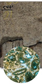
The Cane Creek shale of the Pennsylvanian Paradox Formation has produced more than 7.8 million barrels of oil and about 7.9 billion cubic feet of gas from 18 fields in the Paradox Basin of southeastern Utah. The Cane Creek is divided into three intervals—A, B, and C; the B interval is the primary oil producer. Finely crystalline dolomites and sandstones in the B interval have been the main targets of successful horizontal drilling programs. Hydrocarbon shows were recognized using nondestructive epifluorescence (EF) microscope techniques on samples from wells in the northern part of the basin. A new, qualitative visual EF rating system was developed and applied to these samples. A variety of EF ratings from each well were plotted and mapped.

This 44-page Special Study provides (1) a summary of the new EF methods used in the study; (2) detailed petrographic and EF descriptions of Cane Creek samples for 31 wells (in three appendices); (3) 16 maps showing potential oil-prone areas for the entire Cane Creek and the A, B, and C intervals; and (4) a statistical analysis of the EF data. The study will help petroleum companies determine exploration strategies and land acquisition areas. It will also be a reference for government land management agencies, county planners, and local landowners in decision making processes and resource assessments.

Hydrogeology of the Malad–Lower Bear River Basin, North-Central Utah and South-Central Idaho
By: Hugh Hurlow

GET IT HERE

This report characterizes the lithology of the younger (i.e., Quaternary) basin fill of the Malad–Lower Bear River basin in north-central Utah to provide a geologic framework for evaluation of groundwater flow and the potential effects of additional future groundwater pumping. Analysis of well-drillers’ logs yielded a coherent lithologic stratigraphy below the valley floor, that consists of alternating predominantly fine-grained and predominantly coarse-grained layers above the Tertiary Salt Lake Formation. These units grade abruptly across a facies transition to heterogeneous, predominantly coarse-grained deposits below the mountain fronts. The valley-floor lithologic succession is consistent with findings from previous studies in Cache Valley and basins along the Wasatch front, and with established Quaternary lake cycles. Three fine-grained layers separated by two gravel layers compose a heterogeneous, composite confining unit below the youngest surficial deposits. Heterogeneous, predominantly coarse-grained deposits between the confining unit and the Salt Lake Formation make up the deep sand and gravel aquifer. Groundwater pumping from the shallow sand and gravel aquifer would cause rapid and direct depletion of stream flow in the Bear River and Malad River, which traverse the basin. Depletion of stream flow and spring flow due to pumping from the deep sand and gravel aquifer would be delayed and dispersed, but not negated, by the composite confining unit.

Big Cottonwood Canyon, Wasatch Range
Photographer: Mike Hylland © 2017

The waters of Lake Blanche reflect Sundial Peak, composed of quartzite of the Big Cottonwood Formation. Rocks in this basin, which formed from sediment that accumulated along a continental margin 900 million years ago, preserve striations (parallel scratches and grooves) that record the down-valley flow of Ice Age glaciers.

Needles District, Canyonlands National Park, San Juan County
Photographer: J. Lucy Jordan © 2017

sltrib.com

Few places on earth offer geology as interesting as that found in Utah. From the Colorado Plateau to the basin and range of the West Desert to the Wasatch Front, the earth on display is almost unmatched in its variety.

READ MORE

kutv.com

(AP) The University of Utah Seismograph Stations has reported a minor earthquake in the southwestern part of the state.

READ MORE