


Update on the Markagunt Gravity Slide: Utah’s Largest Landslide Just Got Bigger–A Lot Bigger
by Robert F. Biek (UGS), David B. Hacker (Kent State University), and Peter D. Rowley (Geologic Mapping Inc.)
In the May 2013 issue of Survey Notes, we introduced the Markagunt Megabreccia, the eroded remains of a 21- to 22-million-year-old landslide that blankets the Markagunt Plateau northeast of Cedar City. At that time, we understood this enigmatic deposit to be Utah’s largest landslide, which we thought was about 500 square miles in extent—considerably larger than all of Salt Lake Valley and a bit more than three-times the size of Utah Lake.
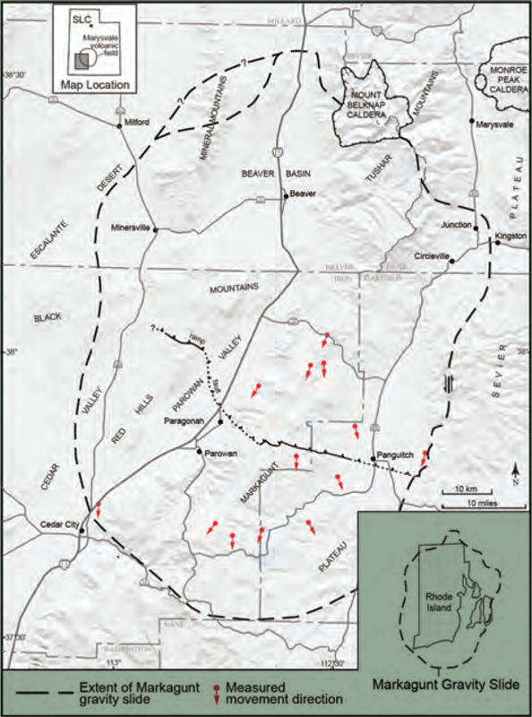
Extent of the Markagunt gravity slide, now understood to be one of the largest terrestrial landslides known on Earth. The slide resulted from catastrophic collapse of the southwestern part of the Marysvale volcanic field about 21 to 22 million years ago. The ramp fault is where the slide mass moved up and over the former land surface. Insets show size of slide in relation to the state of Rhode Island and location with respect to the Marysvale volcanic field.
Since then, new geologic mapping between Cedar City and Beaver shows that this landslide is much, much larger. We call it the Markagunt gravity slide (gravity slides are a special class of extremely large landslides).
We summarized this new discovery in the November 2014 issue of Geology. At about the same time, we also published a field guide, sharing the history of its discovery and 17 exceptionally instructive exposures, in Geology of Utah’s Far South, Utah Geological Association Publication 43. In both reports, we hypothesized its size to be about 1300 square miles. Ongoing research in 2014 and 2015 enabled us to identify the eastern flanking fault, which bounds the east margin of the gravity slide near the western edge of the Sevier Plateau, and the western flanking fault, which bounds the west margin in the central Black Mountains. Additional exposures of deformed rocks in the southern and western Tushar Mountains, eastern Black Mountains, and Mineral Mountains further expands the known extent of rocks involved in this gigantic landslide.
In fact, we now estimate the Markagunt gravity slide is at least 2000 square miles in extent and thus similar in size to the newly redefined 2000-square-mile Heart Mountain gravity slide in northwestern Wyoming; both now vie for the title of Earth’s largest terrestrial landslide (larger submarine landslides are known in ocean basins and former submarine basins on Mars). Additionally, the discovery in 2015 of intensely deformed rocks in the nearby southern Sevier Plateau shows that those volcanic rocks also moved catastrophically, likely as a large (at least 500 square miles) gravity slide somewhat older than the Markagunt gravity slide. The ultimate slide plane of both landslide masses is a gently south-tilted volcaniclastic unit of incompetent (greasy) tuffaceous mudstone and sandstone beneath the volcanic rocks.
The Markagunt gravity slide consists of Miocene and Oligocene (about 20 to 30 million years old) volcanic mudflow deposits, lava flows, and volcaniclastic sedimentary rocks derived from the Marysvale volcanic field, and intertonguing ash-flow tuffs mostly derived from the Indian Peak and Caliente caldera complexes (located near the present-day Utah-Nevada border). A basal slip surface with striations, grooves, and distinctive fractures, a basal zone of crushed and sheared rock and associated clastic dikes, and pulverized rock (ultracataclasite) and friction-generated melt rock (pseudotachylyte) on shear planes and in dikes emanating from these shear planes provide strong evidence of catastrophic emplacement from the north as part of a gigantic landslide. This is the first reported occurrence of landslide-generated pseudotachylyte in North America and is among only a handful of examples known throughout the world.
From its breakaway zone in the southern Tushar Mountains to the southern limit of its debris-avalanche deposits near Cedar Breaks National Monument, the Markagunt gravity slide is nearly 65 miles long and locally at least 40 miles wide. We document southward transport of at least 20 miles over the former early Miocene land surface, and suggest that this movement was extremely rapid, possibly approaching speeds of 200 miles per hour. We suggest that the slide represents catastrophic gravitationally induced collapse of the southwestern part of the Marysvale volcanic field.
The Markagunt gravity slide exhibits the full range of structural features commonly seen in modern landslides, including compression and resultant thrust faulting in the gravity slide’s toe area, simple translational movement across the main body of the gravity slide, and extensional faulting in the upper parts (breakaway zone) of the gravity slide. These facts, coupled with the gigantic size of the gravity slide, illustrate why the gravity slide remained undiscovered for so long and why early interpretations were necessarily incomplete and oft-times apparently conflicting. In addition, basin-range tectonism that eventually created the present topography followed the gravity slide to add confusion to the age of gravity-slide structures.
Understanding the Markagunt gravity slide is important because it opens the door to re-evaluation of other large volcanic centers that may conceal exceptionally large, as-yet unrecognized landslides. It represents a new class of low-frequency but high-impact hazards associated with catastrophic collapse of large volcanic fields containing multiple volcanoes, and it serves as an analog to better understand these rare, extreme events. Magmatic doming and resultant lateral spreading of modern volcanic fields—which proceeds catastrophic collapse and is known in many places around the world, including the Big Island of Hawaii, Mount Etna in Sicily, and the Canary Islands—could have important implications for hazard assessment of potential gigantic landslide events from collapsing volcanic fields.
