Energy News: UGS Explores for New Geothermal Resources in Utah
By Rick Allis and Bob Blackett
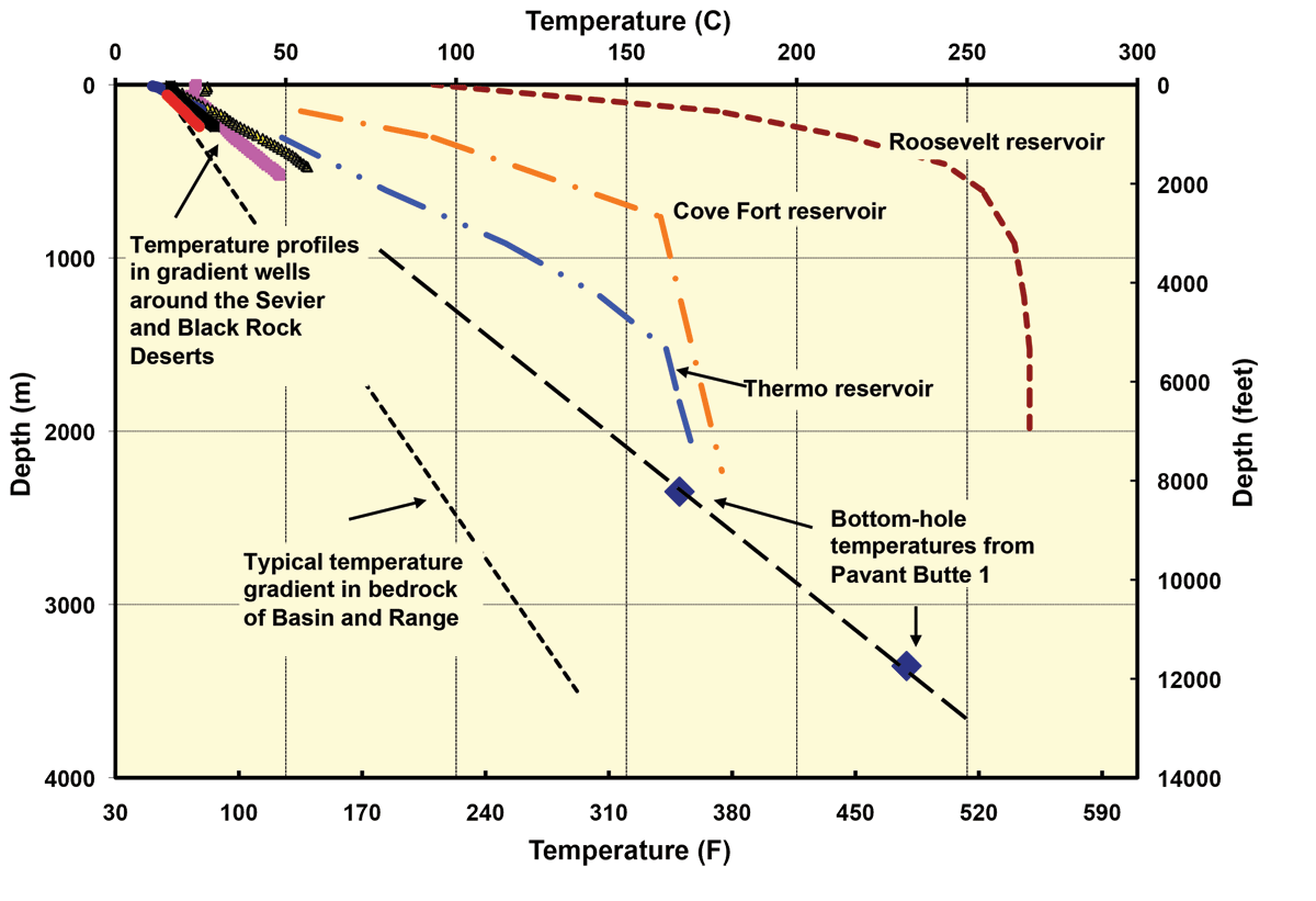
This past spring the Utah Geological Survey (UGS) contracted the U.S. Geological Survey research drilling team to drill two thermal gradient wells in the Sevier and Black Rock Deserts to investigate a new type of geothermal resource: Great Basin sedimentary-hosted geothermal reservoirs. Most geothermal power plants around the world tap into plumes of hot water that rise towards the ground surface along near-vertical fault zones. PacifiCorp’s Blundell power plant (36 megawatts) near Milford in Beaver County is a good example of this. Here, production wells encounter a reservoir on the Opal Mound fault zone adjacent to the Mineral Mountains where temperatures of 500°F occur between depths of about 2000 and 7000 feet.
The sedimentary geothermal reservoirs that we seek are deeper, perhaps 8000 to 13,000 feet, with temperatures of more than 300°F (ideally more than 400°F). In contrast to the narrow, near vertical fault zone reservoirs, we believe these sedimentary reservoirs are sub-horizontal and confined to the more extensive and permeable layers within the bedrock. Because of the extra depth, geothermal companies have been reluctant to risk their exploration dollars on relatively deep wells with an unproven target. However, drilling technologies and costs have been steadily improving over recent years, and drilling to such depths is now common in oil and gas exploration. Since 2007, over 1200 oil and gas wells have been drilled to depths of between 9000 and 19,000 feet in Utah (mostly the Uinta Basin), representing 32 percent of all the oil and gas wells drilled during this time. The UGS hopes that its geothermal investigations will attract geothermal companies to drill for this deeper but more extensive type of reservoir.
Two important factors that control the power potential of a geothermal reservoir are temperature and permeability. The temperature determines the energy content of the water and the permeability determines how much water will flow into the well. Western Utah is part of the Basin and Range physiographic province, an area characterized by young volcanic rocks, range-bounding faults, and naturally high heat flow. Away from fault zones where groundwater movement sometimes disturbs ground temperatures, the temperature gradient in bedrock strata (i.e., beneath the ranges) is typically about 2°F per 100 feet, but beneath unconsolidated sediments in the basins the gradient climbs to 3.3–4.4°F per 100 feet. The higher gradient is due to the insulating properties of the unconsolidated sediment, and it means that the temperatures at about 10,000 feet beneath basins could be around 400°F. If the bedrock that underlies these sediments has zones of high permeability, the geothermal energy potential could be large. Evidence from bedrock exposures in the ranges of western Utah shows that some of the Paleozoic limestone formations, which also underlie the basins, do have characteristically high permeability.
The Sevier and Black Rock Deserts attracted us as a possible location for sedimentary geothermal reservoirs because of the bottom-hole temperatures observed during the drilling of an oil exploration well in 1981—the Pavant Butte 1 (PB-1) well (now abandoned). These temperatures, including a 480°F temperature at the well’s total depth of 11,000 feet, indicate a gradient of 4°F per 100 feet. The PB-1 well encountered 9000 feet of relatively unconsolidated sediments before penetrating an unconformity (major time break) and underlying ancient (Cambrian) bedrock.
When choosing locations for the two new thermal gradient wells, we considered where we already had temperature data in the region and where the largest gaps in data were. In 2010, the Utah Division of Wildlife Resources drilled a water investigation well in the Clear Lake wildlife management area near the PB-1 well, and temperatures in this new well were consistent with a high thermal gradient. Two other thermal gradient wells drilled by Phillips Oil Company in the early 1980s southwest and northeast of Pavant Butte also showed high gradients. We therefore decided to site one of our wells adjacent to Crater Bench (Fumarole Butte volcano) northwest of Delta, and the other in the volcanic rocks south of Pavant Butte and west of Fillmore. Abraham hot springs on the east side of Crater Bench has a large outflow of hot water at temperatures up to 190°F, but there has never been a serious investigation of the thermal conditions at depth. Both wells were drilled to 800 feet, and both entered unconsolidated lake sediments below about 150 feet depth. Preliminary measurements indicate gradients between 3.5 and 4°F per 100 feet. These initial results point to relatively high temperatures (around 400°F at 10,000 feet depth) beneath the region.
The UGS has recently received funding from the Department of Energy to drill several more thermal gradient wells to improve understanding of the geothermal power potential of Utah. We intend to site these wells in the same region to confirm and better delineate the extent of high temperatures at depth. The broad basin beneath the Sevier and Black Rock Deserts, containing as much as 10,000 feet of unconsolidated sediments, extends over 70 miles from Milford to north of Delta, so we are excited about the geothermal potential of this entire basin. The region is already the site of the 300-megawatt Milford-Wind wind farm and the Roosevelt geothermal field, and the Thermo geothermal field (Hatch power plant; 10 megawatts) lies about 20 miles to the south. Perhaps the Sevier–Black Rock Desert region could soon become a renewable power hub in the western U.S.
Survey Notes, v. 43 no. 3, September 2011


