Tag Archive for: utah

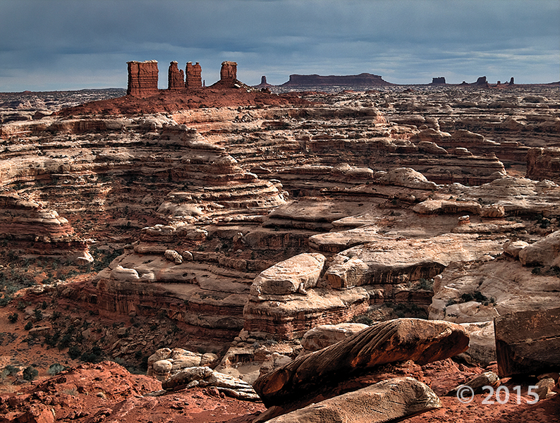
A spectacular look at the geology in southern Utah—a lasting display of nature’s effect on rock.

livescience.com

Southwest of Moab, Utah, is an area of the American Southwest that is truly a showcase of geology. Check out these stunning images of one of the most geologically and biologically rich environments in North America.

READ MORE

Chocolate Drops, Maze District of Canyonlands National Park, Wayne County, Utah Photographer: Tyler Knudsen; © 2015

Fall is upon us and October is just around the corner. If there were a Pumpkin Spice Geology, maybe it would look a little like this photo. What do you think? We’re in the Fall spirit here at the UGS!

9-29-15

Chocolate Drops, Maze District of Canyonlands National Park, Wayne County, Utah
Photographer: Tyler Knudsen; © 2015

If you missed it a couple of weeks ago, here is an article outlining the paleoseismic study some of our UGS geologists helped with on a trench.

nextcity.org

Not far from I-215 in Salt Lake City, near the airport, a deep trench cuts through the earth. Though it looks like a sewer repair project, there’s nothing down here but dirt. And dirt, to the trained eye, can reveal quite a bit about a city’s future.

READ MORE

Students unearth Provo’s Hinckley mounds to find history of past dwellers, and clues that provide answers for future development considerations.

ksl.com

Not far from the bustling center of Provo, students have been working to uncover details about the lives of those who lived in the area more than a thousand years ago.

READ MORE

Alpenglow illuminates the glacially sculpted Stansbury Mountains as seen from the shores of Great Salt Lake. Deseret Peak (11,031 feet), the leftmost high summit, is the range’s highest peak and is underlain by Cambrian-age Prospect Mountain Quartzite. Stansbury Mountains, Tooele County, Utah. Photographer: Gregg Beukelman; © 2015

Have a wonderful weekend, everyone!

POTD 9-25-15 Stansbury Mountains Tooele County

Stansbury Mountains, Tooele County, Utah
Photographer: Gregg Beukelman; © 2015

Alpenglow illuminates the glacially sculpted Stansbury Mountains as seen from the shores of Great Salt Lake. Deseret Peak (11,031 feet), the leftmost high summit, is the range’s highest peak and is underlain by Cambrian-age Prospect Mountain Quartzite.

2016 Calendar_Cover_sm

The Utah Geological Survey 2016 Calendar of Utah Geology has arrived. The calendars are on sale for $4.95 each or $4.25 for orders of 10 or more at the Natural Resources Map & Bookstore, 1594 West North Temple in Salt Lake City.

The photos are taken by staff members who are often on assignment in some of the most intriguing areas of the state.

GET IT HERE!

© 2016

SNTS_47-3_Sept2015_Cover Survey Notes

Our latest issue of Survey Notes is out! Check it out on our Survey Notes Gallery HERE.

The USSC is the central state organization for reducing Utah’s earthquake risk by coordinating efforts, developing public policy, and disseminating results. Here you can find a large earthquake Salt Lake City scenario, and helpful booklet “Putting Down Roots” on preparing for earthquakes. Use the search to find all other USSC documents including photographs and PDFs. Visit the website HERE to help make a plan with your family and friends!

Other helpful links:
Where to Find Earthquake Information
Putting Down Roots PDF

Last week’s flash flood tragedies are a reminder that the mesmerizing and beautiful slot canyons and flood washes in Utah can also become very dangerous.

nationalparkstraveler.com

As wondrous and mesmerizing as slot canyons in southern Utah and northern Arizona can be, they can be even more deadly, as last week’s tragedy at Zion National Park underscores.

READ MORE