Tag Archive for: UGS

Stikes Utahraptor excavation 1 Scott Madsen
UGS paleontologist Scott Madsen cutting the plaster jacket off of the bottom of a block from the Stikes Utahraptor excavation. This roughly 1,000 lb block, dubbed “The Mushroom”, and containing the remains of Iguanodont and Utahraptor dinosaurs, was collected from on top of the large 18,000 lb. block of dinosaur fossils that was dragged off of a mesa in eastern Utah in the fall of 2014.

Stikes Utahraptor excavation 2 Scott Madsen
Scott Madsen begins the preparation of “The Mushroom” in the UGS paleontological laboratory.

GeoSight Devils Playground

Do you think playgrounds are boring? Are you getting sick of the same old swing and slide? Well check out this playground—it rocks!

Devils Playground is not your typical playground at the park, but a playground of granitic rock weathered into fantastic forms and eerie shapes. Located on Bureau of Land Management and state land, Devils Playground is a relatively unknown geologic curiosity found in a remote region of northwestern Utah.

Devils Playground consists of Tertiary-age (approximately 38 million years old) granitic rock formed from a cooling magma body that intruded overlying Paleozoic (400 to 300 million years old) sedimentary rocks. Known as the Emigrant Pass pluton, this intrusion covers an area of approximately 10 square miles in the southern part of the Grouse Creek Mountains.

Check out more on Devil’s Playground HERE.

Take a tour of our other GeoSights HERE.

House Range, Millard County, Utah Photographer: J. Lucy Jordan; © 2014

POTD 2-17-15 House Range, Millard County

House Range, Millard County, Utah
Photographer: J. Lucy Jordan; © 2014

Where’s winter? On the upside, today feels a little like this photo—it is gorgeous out there. The mid-week peak is here with another weekend on the way. Who’s got outdoor adventures in their forecast??

San Rafael Swell and Henry Mountains from Temple Mountain, Emery County, Utah Photographer: Paul Kuehne; © 2014

This photo shows another way that ‪#‎UtahGeology‬ can really knock you off of your feet. Don’t forget your sea legs as you look out over the vast sea of geology!

POTD 2-10-15 San Rafael Swell, Henry Mountains, Emery County

San Rafael Swell and Henry Mountains from Temple Mountain, Emery County, Utah
Photographer: Paul Kuehne; © 2014

The Green River forms a dramatic “gooseneck” near Sand Wash in upper Desolation Canyon. The river has incised into rocks of the Douglas Creek and Parachute Creek Members of the Tertiary-age Green River Formation, which comprises sediments that accumulated in ancient Lake Uinta. Desolation Canyon, Uintah County, Utah Photographer: Adam Hiscock; © 2014

Hey friends, we’ve finally made way with our new website! Visit geology.utah.gov to see our new look. Though, as most technical endeavors, we’ve encountered some difficulties. Switching the URLs erased our subscription list, and those who subscribed to our “New Blog,” you will have to re-subscribe. We apologize for the inconvenience, but we hope you’ll forgive us when you see this pretty picture of Utah geology.

new-blog

POTD 2-3-15 Desolation Canyon, Uintah County, Green River

Desolation Canyon, Uintah County, Utah
Photographer: Adam Hiscock; © 2014

The Green River forms a dramatic “gooseneck” near Sand Wash in upper Desolation Canyon. The river has incised into rocks of the Douglas Creek and Parachute Creek Members of the Tertiary-age Green River Formation, which comprises sediments that accumulated in ancient Lake Uinta.

Bryce Canyon National Park, Garfield County, Utah Photographer: Danielle Lehle; © 2014

POTD 1-27-15 Bryce Canyon National Park, Garfield County

Bryce Canyon National Park, Garfield County, Utah
Photographer: Danielle Lehle; © 2014

Turret Arch viewed through North Window arch in The Windows Section of Arches National Park. The arches formed as the result of erosion through weak parts of sandstone fins composed of Jurassic-age Dewey Bridge Member of the Carmel Formation and Slick Rock Member of the Entrada Sandstone. Arches National Park, Grand County, Utah Photographer: Gregg Beukelman; © 2014

POTD 1-20-15 Arches National Park, Grand County, Turret Arch

Arches National Park, Grand County, Utah
Photographer: Gregg Beukelman; © 2014

Turret Arch viewed through North Window arch in The Windows Section of Arches National Park. The arches formed as the result of erosion through weak parts of sandstone fins composed of Jurassic-age Dewey Bridge Member of the Carmel Formation and Slick Rock Member of the Entrada Sandstone.

Goosenecks of the San Juan River from Goosenecks State Park, San Juan County, Utah. Photographer: Marshall Robinson; © 2014

POTD 1-13-15 Goosenecks, San Juan County, State Park

Goosenecks State Park, San Juan County, Utah
Photographer: Marshall Robinson; © 2014

Goosenecks of the San Juan River from Goosenecks State Park, San Juan County.

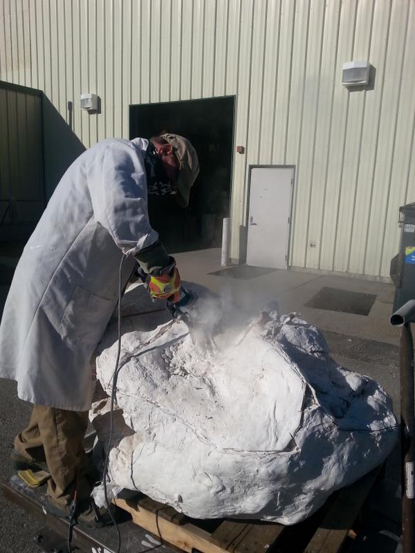
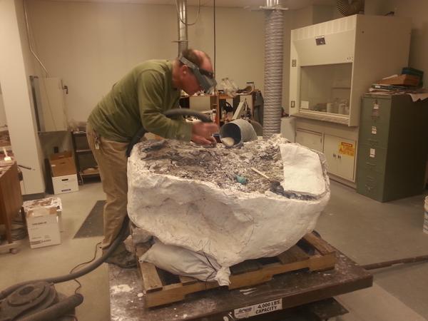
Remember the family of Utah Raptors that arrived in a 9-ton ‘block’ in Salt Lake City a few months ago? Our Paleontologists here at the UGS have been working very closely on this project for years. Check out this wonderful highlight on their work so far, where you can see interviews from Utah State Paleontologist James Kirkland, and Paleontologists, Don DeBlieux and Scott Madsen.

news.nationalgeographic.com

A nine-ton block of sandstone that was pulled from a Utah mountain late last year holds the biggest fossil trove ever found of the giant predatory dinosaur known as Utahraptor. Covered in feathers, with a huge sickle claw on each second toe, Utahraptor looked like a pumped-up version of the Jurassic Park star Velociraptor.

READ MORE

And further reading in this article below…

Fossil treasure trove in quicksand reveals ancient dinosaur death trap

washingtonpost.com

Reports of what looked like a human arm brought Utah state paleontologist James Kirkland to a particular sandstone hill in 2001. But it turned out that his graduate student had actually found something entirely different — a veritable mass grave of Utahraptor dinosaurs. Now they’ve found the remains of six individual dinosaurs, and there may still be more inside of the 9-ton sandstone block they’re excavating.

READ MORE


Late-winter ice still clings to the Colorado River near Big Bend, north of Moab. Boulders of Jurassic-age Wingate Sandstone and Triassic-age Chinle Formation line the banks of the river, eroded from the cliffs and ledges cut by the river as it has incised its channel over millions of years. Colorado River, Grand County, Utah Photographer: Adam Hiscock; © 2014

POTD 1-6-15 Colorado River, Grand County, Utah

Colorado River, Grand County, Utah
Photographer: Adam Hiscock; © 2014

Late-winter ice still clings to the Colorado River near Big Bend, north of Moab. Boulders of Jurassic-age Wingate Sandstone and Triassic-age Chinle Formation line the banks of the river, eroded from the cliffs and ledges cut by the river as it has incised its channel over millions of years.