Tag Archive for: Colorado River

 © 2019 Jessica Castleton
Colorado River near Moab, Grand County
Photo by Jessica Castleton.
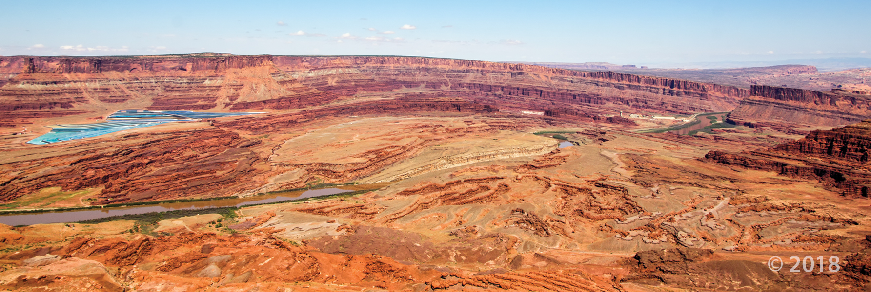
Colorado River, Cane Creek anticline, and potash evaporation ponds, San Juan County
Photographer: Adam Hiscock © 2018
View east from Jackson Bottom along the Colorado River, Grand County.
Photographer: Brian Butler © 2017


Along the Colorado River, Grand County
Photographer: Ryhan Sempler © 2016

A view to drink in over your lunch time daydream.

Cane Creek anticline and the Colorado River, Grand County, Utah
Photographer: Rebekah Stimpson; © 2015

While this photo is a throwback to colder seasons, we cannot deny the stunning #UtahGeology present. This crisp, cold picture is worth a thousand hand warmers—that’s how the saying goes, right?

Dead Horse Point State Park, San Juan County, Utah
Photographer: Gregg Beukelman; © 2014
The Colorado River loops around the Gooseneck between Dead Horse Point State Park and distant cliffs of the Island in the Sky District of Canyonlands National Park. The river has carved and exposed nearly flat-lying Jurassic to Pennsylvanian-age sedimentary strata of the Colorado Plateau.


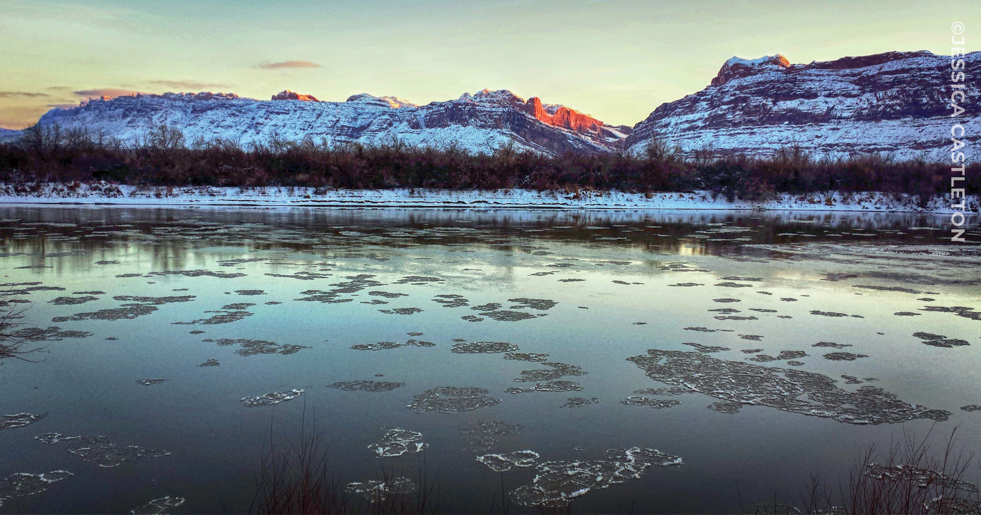
Colorado River, Grand County, Utah
Photographer: Adam Hiscock; © 2014
Late-winter ice still clings to the Colorado River near Big Bend, north of Moab. Boulders of Jurassic-age Wingate Sandstone and Triassic-age Chinle Formation line the banks of the river, eroded from the cliffs and ledges cut by the river as it has incised its channel over millions of years.
In more recent times, focus has been on the drought conditions affecting Southern Utah and the Colorado River. But what if the Colorado River were flooding? An interesting insight to the river’s extreme flood history, and research for better understanding of the rare events.
latimes.com
Scientists say it would have been a catastrophe of unprecedented proportions. If the Glen Canyon Dam had failed, it would have changed the lives of millions of people and reshaped the history of the American West.
READ MORE
 Glen Canyon National Recreation Area, San Juan County, Utah
Photographer: Don DeBlieux; © 2011
Dinosaur tracks on a block of fallen Jurassic-age Navajo Sandstone. North of the confluence of the San Juan and Colorado Rivers, Glen Canyon National Recreation Area, San Juan County.
Tag Archive for: Colorado River
Colorado River near Moab, Grand County
Photo by Jessica Castleton.
Colorado River, Cane Creek anticline, and potash evaporation ponds, San Juan County
Photographer: Adam Hiscock © 2018
View east from Jackson Bottom along the Colorado River, Grand County.
Photographer: Brian Butler © 2017
Along the Colorado River, Grand County
Photographer: Ryhan Sempler © 2016
A view to drink in over your lunch time daydream.
Cane Creek anticline and the Colorado River, Grand County, Utah
Photographer: Rebekah Stimpson; © 2015
While this photo is a throwback to colder seasons, we cannot deny the stunning #UtahGeology present. This crisp, cold picture is worth a thousand hand warmers—that’s how the saying goes, right?
Dead Horse Point State Park, San Juan County, Utah
Photographer: Gregg Beukelman; © 2014
The Colorado River loops around the Gooseneck between Dead Horse Point State Park and distant cliffs of the Island in the Sky District of Canyonlands National Park. The river has carved and exposed nearly flat-lying Jurassic to Pennsylvanian-age sedimentary strata of the Colorado Plateau.
Colorado River, Grand County, Utah
Photographer: Adam Hiscock; © 2014
Late-winter ice still clings to the Colorado River near Big Bend, north of Moab. Boulders of Jurassic-age Wingate Sandstone and Triassic-age Chinle Formation line the banks of the river, eroded from the cliffs and ledges cut by the river as it has incised its channel over millions of years.
In more recent times, focus has been on the drought conditions affecting Southern Utah and the Colorado River. But what if the Colorado River were flooding? An interesting insight to the river’s extreme flood history, and research for better understanding of the rare events.
latimes.com
Scientists say it would have been a catastrophe of unprecedented proportions. If the Glen Canyon Dam had failed, it would have changed the lives of millions of people and reshaped the history of the American West.
READ MORE
Glen Canyon National Recreation Area, San Juan County, Utah
Photographer: Don DeBlieux; © 2011
Dinosaur tracks on a block of fallen Jurassic-age Navajo Sandstone. North of the confluence of the San Juan and Colorado Rivers, Glen Canyon National Recreation Area, San Juan County.
LEARN MORE ABOUT THE UTAH GEOLOGICAL SURVEY
![]()
The Utah Geological Survey (UGS) is a division of the Utah Department of Natural Resources. Several specialized programs comprise the UGS: Data Management, Energy & Minerals, Geologic Hazards, Geologic Information & Outreach, Geologic Mapping, Groundwater & Wetlands, and Paleontology.
QUICK LINKS
CONTACT INFORMATION
Staff Directory1594 West North Temple, Suite 3110
Salt Lake City, Utah 84116
801-537-3300 (phone)
801-537-3400 (fax)
Mailing Address:
PO BOX 146100
Salt Lake City, Utah 84114
HOURS
Monday through Friday,8 a.m. to 5 p.m.