Tag Archive for: Calendar of Utah Geology

 Lance Weaver
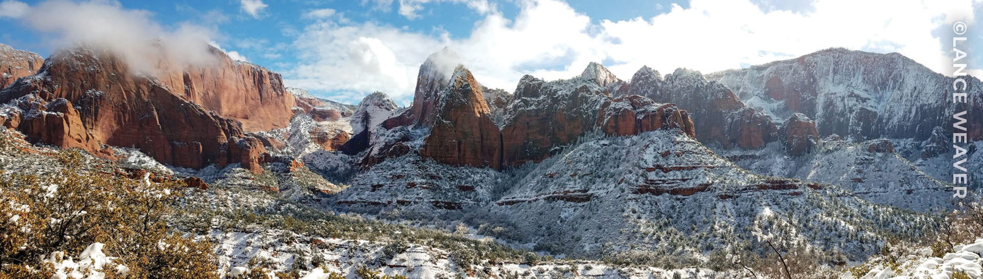
Navajo Sandstone, Zion National Park, Washington County. Photo by Lance Weaver.
 Trevor Schlossnagle
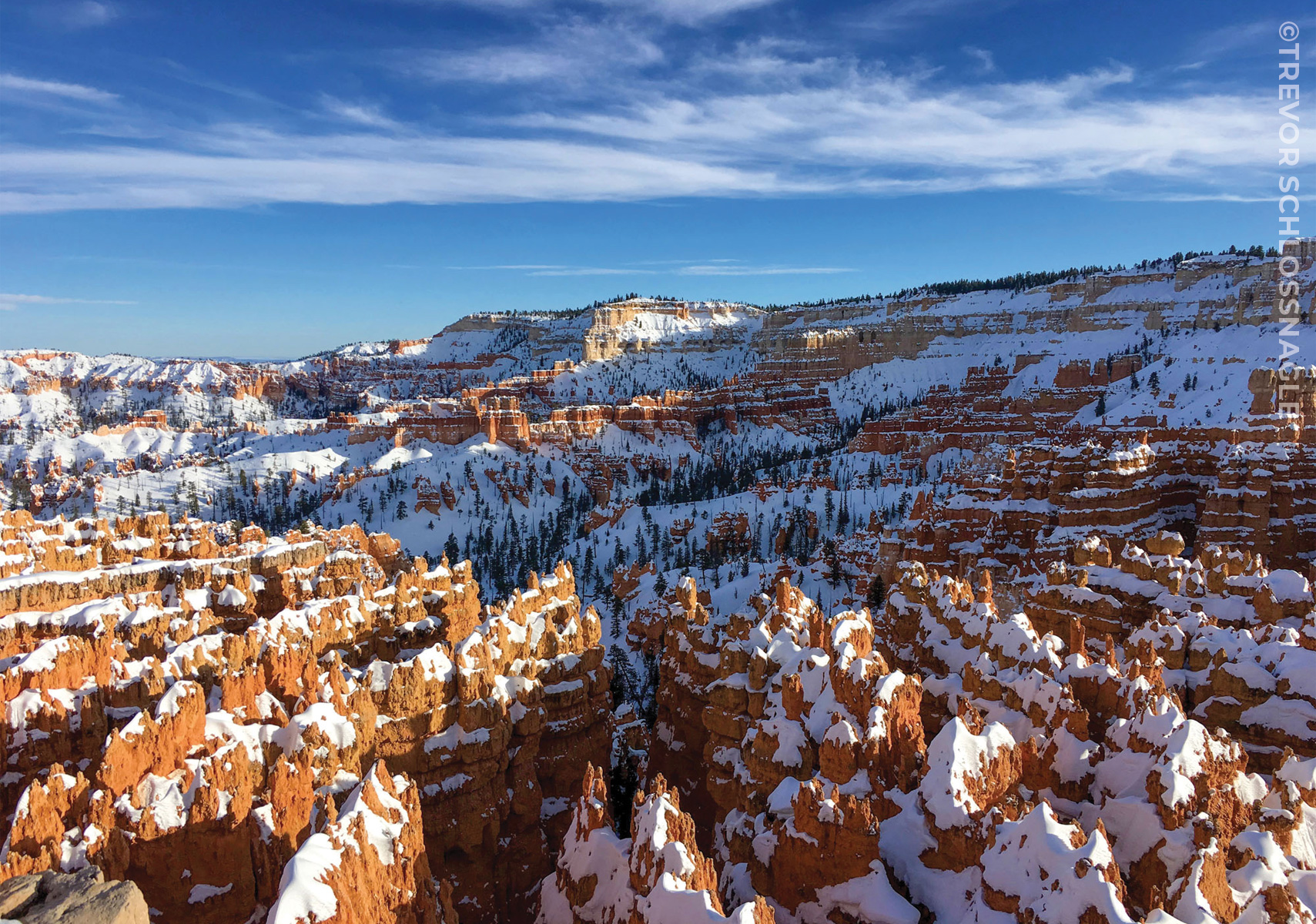
Snow-capped hoodoos of the Eocene-age Pink Member of the Claron Formation glow in the evening sun. These hoodoos were sculpted by the effects of weathering and erosion from ice and rain. Learn more about how hoodoos are formed.
Bryce Canyon National Park, Garfield County. Photo by Trevor Schlossnagle.

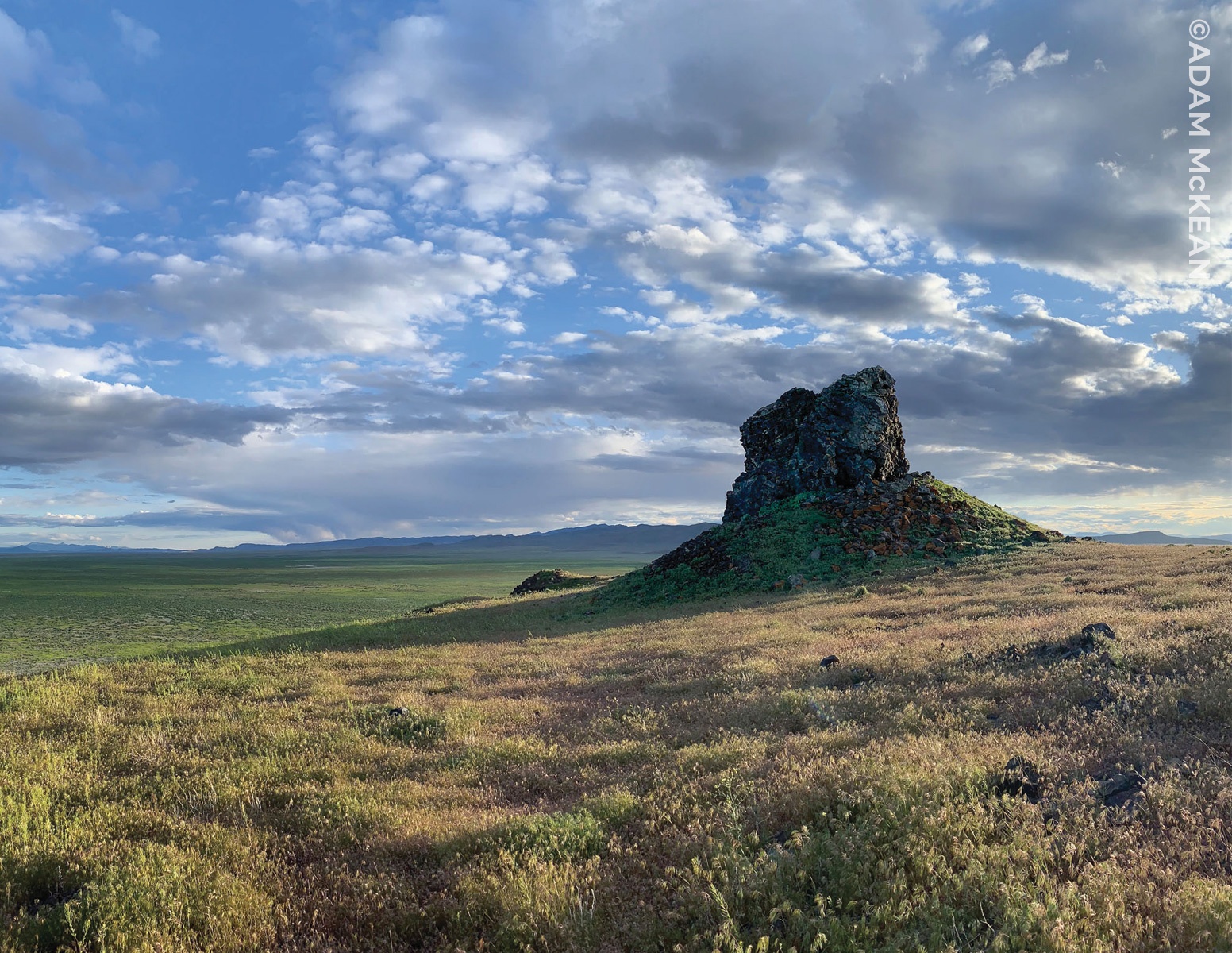
The evening sun casts a long shadow of a basaltic knob at Pot Mountain. These early Pleistocene-age rocks are likely eroded volcanic necks that may have erupted into water. The vents are now eroded and partially concealed by shoreline gravel of the late Pleistocene Lake Bonneville, giving the mountain a teapot-like shape when viewed from a distance.
Sevier Desert, Millard County. Photo by Adam McKean.


Media Contact
Vicky Clarke
801-537-3330
vickyclarke@utah.gov
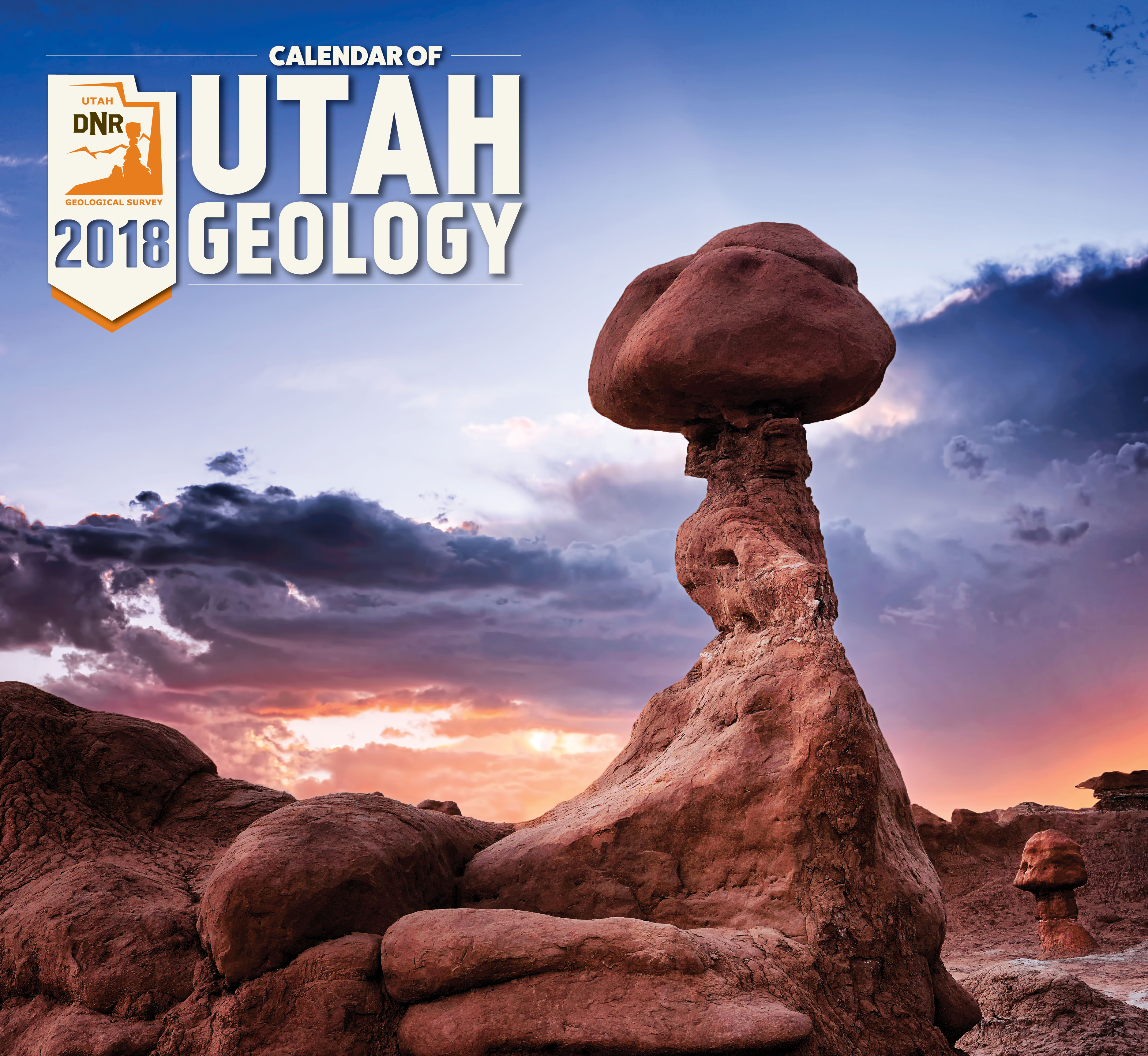
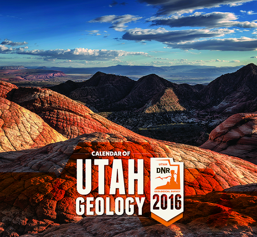
2018 Calendar of Utah Geology is the Best Yet!
The Utah Geological Survey (UGS) recently released the 12th edition of its popular Calendar of Utah Geology. The 2018 calendar features inspiring photographs by UGS staff of Utah’s geologic wonders with a brief explanation of how and when they formed.
Weathering and erosion of the Jurassic-age Entrada Sandstone forms a fantastic array of stone structures locally referred to as “goblins.” Goblin Valley State Park, Emery County. Photographed by Gregg Beukelman.
Eight years ago Gregg Beukelman, whose photograph was selected for the calendar’s cover, moved to Utah from Idaho when he landed his current job as a geologist with UGS’s Geologic Hazards Program. After the move Beukelman found himself with free time in what he describes as “hands down the most beautiful state in the nation.”
Beukelman previously had a passing interest in photography, but it was Utah’s incredible landscapes and vistas that stoked his passion. He now spends many of his off-work hours traveling across Utah searching out vistas and awaiting lighting conditions that allow him to create his stunning images. Like other employees whose photographs have been featured in the calendar, Beukelman’s have transformed from nice landscape shots to true works of art.
Beukelman is not alone in his path from geology to photography. The calendar has featured more than 40 UGS geologists. Other staff members have taken an opposite tack and were previously artists who sought employment with UGS because of their love of the outdoors and curiosity about geology. UGS graphic designer John Good and Natural Resources Map & Bookstore clerk Andy Cvar are both featured in this year’s calendar.
Both the artists who have turned to geology and the geologists who have turned to art have contributed to a tradition of growing excellence to create what proves to be the best Calendar of Utah Geology to date!
The 2018 Calendar of Utah Geology is the same price as last year, $4.95 each or $4.25 for orders of 10 or more, and is available at the Natural Resources Map & Bookstore, 1594 West North Temple, Salt Lake City, (801) 537-3320 or 1-888-UTAHMAP. They may also be purchased online.
The Utah Geological Survey provides timely scientific information about Utah’s geologic environment, resources, and hazards. It is one of seven divisions within the Utah Department of Natural Resources.
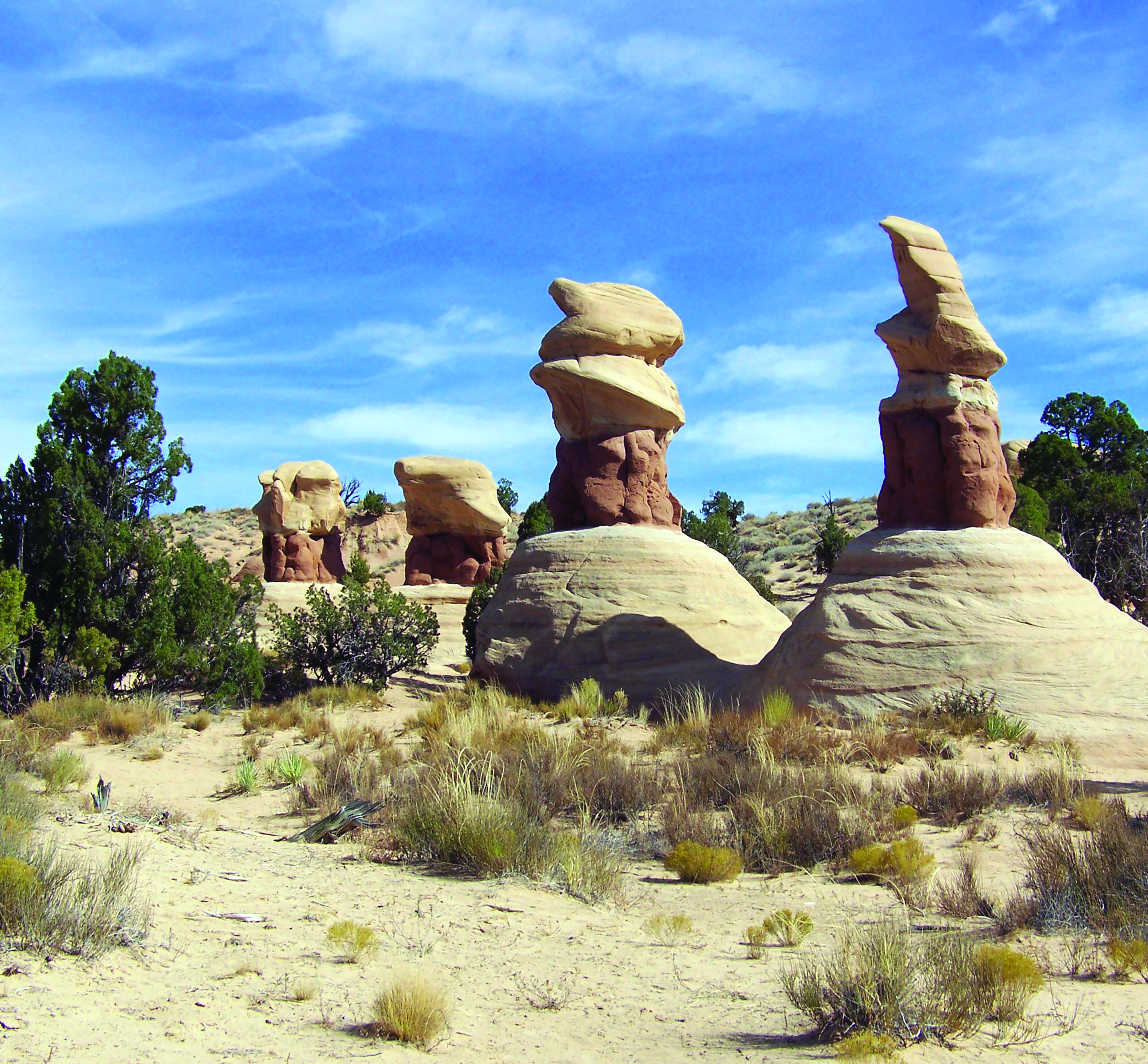
The hoodoos of Devils Garden, Grand Staircase–Escalante National Monument, Garfield County. Photographed by John Good.
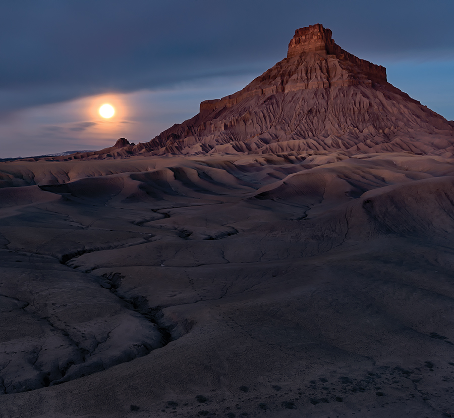
Morning glow and moonset over the Cretaceous-age Mancos Formation of Factory Butte, Wayne County. Photographed by Gregg Beukelman.

Reduced and oxidized mudstone of the Triassic-age Chinle Formation in the San Rafael Swell, Emery County. Photographed by Natural Resources Map and Bookstore clerk Andy Cvar.

Another highlight on the 2016 Calendar of Utah Geology—get yours in time before they’re all gone!
Get them in store at the Utah Natural Resources Map & Bookstore, or online HERE.
deseretnews.com
Some of Utah’s most spectacular displays of geography are once again being showcased in the annual calendar compiled by staff members of the Utah Geological Survey.
Another feature on our recently released 2016 Calendar of Utah Geology. If you haven’t looked yet, check it out!
suindependent.com
The Utah Geological Survey, which provides timely scientific information about Utah’s geologic environment, resources, and hazards, released its 2016 calendar of Utah geology. The Utah Geological Survey 2016 calendar features some of Utah’s most rarely seen vistas as photographed by UGS staff as they travel the state researching and studying these geologic wonders.
The Utah Geological Survey 2016 Calendar of Utah Geology has arrived. The calendars are on sale for $4.95 each or $4.25 for orders of 10 or more at the Natural Resources Map & Bookstore, 1594 West North Temple in Salt Lake City.
The photos are taken by staff members who are often on assignment in some of the most intriguing areas of the state.
© 2016
Tag Archive for: Calendar of Utah Geology
Navajo Sandstone, Zion National Park, Washington County. Photo by Lance Weaver.
Snow-capped hoodoos of the Eocene-age Pink Member of the Claron Formation glow in the evening sun. These hoodoos were sculpted by the effects of weathering and erosion from ice and rain. Learn more about how hoodoos are formed.
Bryce Canyon National Park, Garfield County. Photo by Trevor Schlossnagle.
The evening sun casts a long shadow of a basaltic knob at Pot Mountain. These early Pleistocene-age rocks are likely eroded volcanic necks that may have erupted into water. The vents are now eroded and partially concealed by shoreline gravel of the late Pleistocene Lake Bonneville, giving the mountain a teapot-like shape when viewed from a distance.
Sevier Desert, Millard County. Photo by Adam McKean.
Media Contact
Vicky Clarke
801-537-3330
vickyclarke@utah.gov
2018 Calendar of Utah Geology is the Best Yet!
The Utah Geological Survey (UGS) recently released the 12th edition of its popular Calendar of Utah Geology. The 2018 calendar features inspiring photographs by UGS staff of Utah’s geologic wonders with a brief explanation of how and when they formed.
Weathering and erosion of the Jurassic-age Entrada Sandstone forms a fantastic array of stone structures locally referred to as “goblins.” Goblin Valley State Park, Emery County. Photographed by Gregg Beukelman.
Eight years ago Gregg Beukelman, whose photograph was selected for the calendar’s cover, moved to Utah from Idaho when he landed his current job as a geologist with UGS’s Geologic Hazards Program. After the move Beukelman found himself with free time in what he describes as “hands down the most beautiful state in the nation.”
Beukelman previously had a passing interest in photography, but it was Utah’s incredible landscapes and vistas that stoked his passion. He now spends many of his off-work hours traveling across Utah searching out vistas and awaiting lighting conditions that allow him to create his stunning images. Like other employees whose photographs have been featured in the calendar, Beukelman’s have transformed from nice landscape shots to true works of art.
Beukelman is not alone in his path from geology to photography. The calendar has featured more than 40 UGS geologists. Other staff members have taken an opposite tack and were previously artists who sought employment with UGS because of their love of the outdoors and curiosity about geology. UGS graphic designer John Good and Natural Resources Map & Bookstore clerk Andy Cvar are both featured in this year’s calendar.
Both the artists who have turned to geology and the geologists who have turned to art have contributed to a tradition of growing excellence to create what proves to be the best Calendar of Utah Geology to date!
The 2018 Calendar of Utah Geology is the same price as last year, $4.95 each or $4.25 for orders of 10 or more, and is available at the Natural Resources Map & Bookstore, 1594 West North Temple, Salt Lake City, (801) 537-3320 or 1-888-UTAHMAP. They may also be purchased online.
The Utah Geological Survey provides timely scientific information about Utah’s geologic environment, resources, and hazards. It is one of seven divisions within the Utah Department of Natural Resources.
The hoodoos of Devils Garden, Grand Staircase–Escalante National Monument, Garfield County. Photographed by John Good.
Morning glow and moonset over the Cretaceous-age Mancos Formation of Factory Butte, Wayne County. Photographed by Gregg Beukelman.
Reduced and oxidized mudstone of the Triassic-age Chinle Formation in the San Rafael Swell, Emery County. Photographed by Natural Resources Map and Bookstore clerk Andy Cvar.
Another highlight on the 2016 Calendar of Utah Geology—get yours in time before they’re all gone!
Get them in store at the Utah Natural Resources Map & Bookstore, or online HERE.
deseretnews.com
Some of Utah’s most spectacular displays of geography are once again being showcased in the annual calendar compiled by staff members of the Utah Geological Survey.
Another feature on our recently released 2016 Calendar of Utah Geology. If you haven’t looked yet, check it out!
suindependent.com
The Utah Geological Survey, which provides timely scientific information about Utah’s geologic environment, resources, and hazards, released its 2016 calendar of Utah geology. The Utah Geological Survey 2016 calendar features some of Utah’s most rarely seen vistas as photographed by UGS staff as they travel the state researching and studying these geologic wonders.
The Utah Geological Survey 2016 Calendar of Utah Geology has arrived. The calendars are on sale for $4.95 each or $4.25 for orders of 10 or more at the Natural Resources Map & Bookstore, 1594 West North Temple in Salt Lake City.
The photos are taken by staff members who are often on assignment in some of the most intriguing areas of the state.
© 2016
LEARN MORE ABOUT THE UTAH GEOLOGICAL SURVEY

The Utah Geological Survey (UGS) is a division of the Utah Department of Natural Resources. Several specialized programs comprise the UGS: Data Management, Energy & Minerals, Geologic Hazards, Geologic Information & Outreach, Geologic Mapping, Groundwater & Wetlands, and Paleontology.
QUICK LINKS
CONTACT INFORMATION
1594 West North Temple, Suite 3110
Salt Lake City, Utah 84116
801-537-3300 (phone)
801-537-3400 (fax)
Mailing Address:
PO BOX 146100
Salt Lake City, Utah 84114
HOURS
Monday through Friday,
8 a.m. to 5 p.m.
![]()