Tag Archive for: Big Cottonwood Canyon

Glacially scoured and polished quartzite of the Precambrian-age Big Cottonwood Formation near Lake Blanche, Big Cottonwood Canyon, Wasatch Range, Salt Lake County. Photo by Adam Hiscock, UGS.

I know there’s snow up in the Wasatch today, but the valley sure feels as nice as this photo!

POTD 3-29-16 Glacier Wasatch

Big Cottonwood Canyon, Wasatch Range, Salt Lake County, Utah
Photographer: Adam Hiscock; © 2015

Glacially scoured and polished quartzite of the Precambrian-age Big Cottonwood Formation near Lake Blanche, Big Cottonwood Canyon, Wasatch Range, Salt Lake County.

Big Cottonwood Canyon, Wasatch Range, Salt Lake County, Utah Photographer: Paul Inkenbrandt; © 2015

Another beautiful morning on the Wasatch Front with another weekend on the way. Big Cottonwood Canyon is looking a little more wintry these days!

POTD 1-19-16 Big Cottonwood Canyon

Big Cottonwood Canyon, Wasatch Range, Salt Lake County, Utah
Photographer: Paul Inkenbrandt; © 2015

Last Thursday the Utah Geological Survey participated in Teens in the Woods: Mapping our Future outdoor program, an education initiative designed to bring underserved, urban, and diverse children and adolescents to the forests to spark curiosity, exercise, and connect the next generation with nature. The week-long event is chock-full of activities set up by scientists from many fields in the Earth sciences, emphasizing conservation, stewardship, science, technology, engineering, and mathematics. On our trip with high school and middle school students we traveled to Big Cottonwood Canyon and Silver Lake to explore geology, forestry, air photo interpretation, and aquatic biology.

Teens in the Woods is a new nation-wide program spearheaded by the U.S. Department of Agriculture/U.S. Forest Service and in the Uinta-Wasatch-Cache National Forest, partnered with some dozen other organizations including the Cottonwood Canyons Foundation and Bad Dog Art.

Ms. Amy discusses water chemistry and lake health with students in the rain.

A student examines a leech and other aquatic invertebrates that inhabit Silver Lake.

A young bull moose examines the students at Silver Lake.

We’ve got a really great #throwbackthursday for you today— The Geologic Exploration of the Fortieth Parallel. The image by Timothy H. O’Sullivan displays Big Cottonwood Canyon in 1869. #tbt

See the photo information HERE

Last Thursday the Utah Geological Survey participated in the More Kids in the Woods outdoor program, an education initiative designed to bring underserved, urban, and diverse children and adolescents to the forests to spark curiosity, exercise, and connect the next generation with nature.  The week-long event is chock-full of activities set up by scientists from many fields in the Earth sciences, emphasizing conservation, stewardship, science, technology, engineering, and mathematics.  On our trip with middle school students we traveled to Big Cottonwood Canyon and Silver Lake to explore geology, forestry, and aquatic biology.

More Kids in the Woods is a new nation-wide program spearheaded by the U.S. Department of Agriculture/U.S. Forest Service and in the Uinta-Wasatch-Cache National Forest, partnered with some dozen other organizations including The University of Utah, Cottonwood Canyons Foundation, and Bad Dog Art.


Students examine rainbow trout from Silver Lake.

Students study air photo interpretion by using photos of the Silver Lake area to identify vegetation types followed by ground truthing on a hike.

A cartographer from the U.S. Forest Service reviews with students and instructors. 

Big Cottonwood Canyon, Wasatch Range, Salt Lake County
Photographer: Liz Paton

On the east slope of Mt. Millicent (10,452 feet), Lake Mary occupies part of a basin carved by Ice Age glaciers. The surrounding peaks are composed of granitic rock of the Tertiary-age Alta stock.

This Issue Contains:

  • Utah’s Glacial Geology
  • Utah’s Pleistocene Fossils: Keys for Assessing Climate and Environmental Change
  • Glad You Asked: Ice Ages – What are they and what causes them?
  • Survey News
  • Teacher’s Corner: Teaching Kits Available for Loan
  • GeoSights: Glacial Landforms in Big and Little Cottonwood Canyons, Salt Lake County, Utah
  • Energy News: Uranium – Fuel for the 21st Century?
  • New Publications

READ THIS ISSUE

PAST ISSUES

slickensides
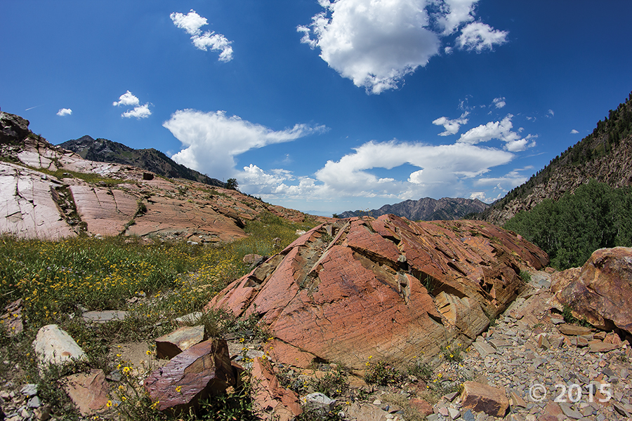
What are those groovy rocks and how did they get that way?
Carole McCalla

On a hike around Lake Blanche below Sundial Peak in Big Cottonwood Canyon, a group of hikers came across long, straight, parallel grooves on a smooth, polished rock surface. Recalling another location where they had seen similar features at the foot of the mountains north of downtown Salt Lake City, they wondered if these markings were formed in the same way. Indeed, what exactly are they and how were they formed?

Although the smooth, grooved surfaces at these two locations are similar, they were actually formed in very different ways.

READ MORE

VIEW SURVEY NOTES