See the state’s spectacular and diverse landscapes through the eyes of the Utah Geological Survey
From snow-covered slopes in American Fork Canyon to sandstone peaks in Utah’s deserts, see the state’s spectacular and diverse landscapes through the eyes of Utah Geological Survey (UGS) employees in the 2023 Calendar of Utah Geology. The calendar captures photogenic features and sites found by UGS scientists and staff working in the field.
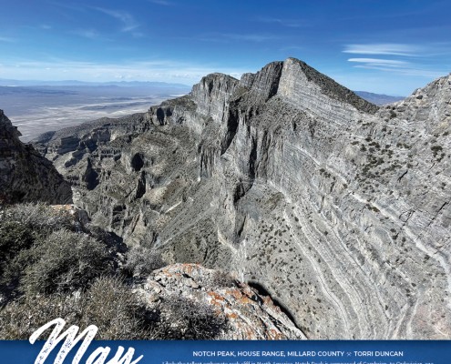
Assistant Bookstore Manager Torri Duncan’s May photo of Notch Peak was taken while hiking to the 9,658-foot peak, which towers atop one of the tallest cliffs in the lower 48 states. As a geologist and part of the UGS Geologic Information and Outreach Program, Torri visits and researches unique geologic formations for articles she writes for the UGS Survey Notes publication.
The March photo of Window Blind Peak was taken with a drone (or small unmanned aerial system – sUAS) by UGS Project Geologist Adam Hiscock while recreating in the San Rafael Swell region in central Utah. As a geologist with the Geologic Hazards Program, Adam researches and investigates geologic hazards and creates reports, maps, and digital data to help reduce the risks associated with geologic hazards in Utah. Adam and other UGS geologists use drones, such as the one used to shoot this photo, to document and characterize geologic hazards, such as rockfalls and landslides.
In addition to stunning photos, the calendar includes a simplified geologic map reflecting the large variety of geologic events from over 2.6 million years that created the spectacular scenery of Utah’s red rock country, high alpine peaks, and expansive basins and ranges.
The 2023 Calendar of Utah Geology is available now for $7.95. Calendars can be purchased online at utahmapstore.com or the Natural Resources Map & Bookstore at 1594 West North Temple in Salt Lake City.
The UGS provides timely scientific information about Utah’s geologic environment, resources, and hazards. Seven programs specializing in fields relating to geology comprise the UGS: Data Management, Energy and Minerals, Geologic Hazards, Geologic Information and Outreach, Geologic Mapping, Groundwater and Wetlands, and Paleontology.


 Drill core from 2022 exploration at West Desert. Sphalerite, shown here, is known for containing zinc, but at West Desert also contains high concentrations of indium.