 Christian Hardwick
Mineral Mountains, Beaver County
Photo by Christian Hardwick
Miocene-age granite in the Mineral Mountains glows as the sun sets over the distant San Francisco Mountains near Milford.

Mineral Mountains, Beaver County
Photo by Christian Hardwick
Miocene-age granite in the Mineral Mountains glows as the sun sets over the distant San Francisco Mountains near Milford.
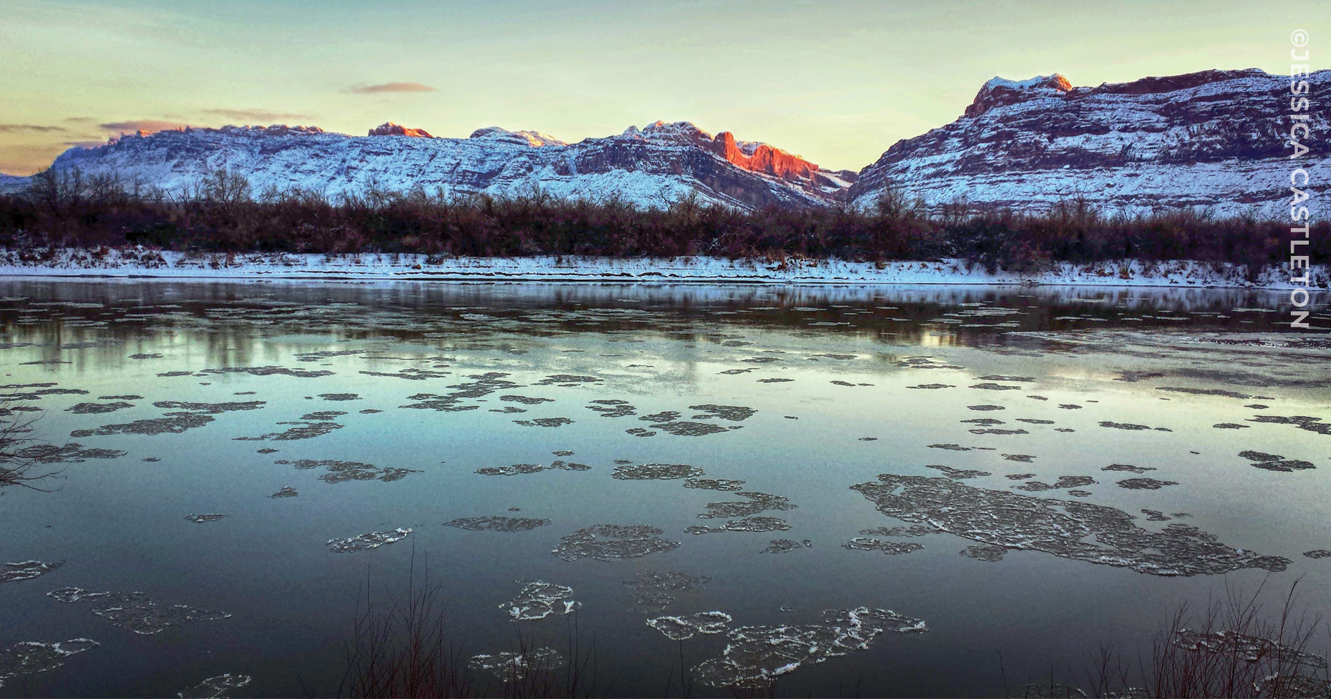
Colorado River near Moab, Grand County
Photo by Jessica Castleton.

State Geologist and Director Rick Allis retired in January after 18 years of service with the UGS. Prior to joining the UGS, Rick was in senior management at the Institute of Geological and Nuclear Sciences in New Zealand, originally known as the New Zealand Geological Survey, and then was a research professor with the Energy and Geoscience Institute at the University of Utah for almost three years. While at the UGS, his steady leadership and strategic vision helped the agency meet a number of challenges over the past two decades. Rick’s emphasis on making all UGS publications available for free on the UGS website, as well as providing geologic information interactively through web applications, led to the creation of the Web Services Section. Anticipating the continuing need for understanding the interactions between geology and water resources, Rick encouraged and supported expansion of groundwater characterization studies and creation of the UGS Wetlands Section. A strong proponent of renewable energy, Rick played a key role in helping Utah be selected as the national Frontier Observatory for Research in Geothermal Energy (FORGE) field laboratory. After Mineral Lease revenues to the UGS plummeted following the crash in oil and gas prices that began in late 2014, Rick’s convincing arguments to the Utah Legislature’s Natural Resources Appropriations Subcommittee concerning the value of the UGS to Utah’s citizens resulted in the 2016 Legislature approving a $1 million ongoing increase in General Funds to the UGS, substantially stabilizing the agency’s budget. As the UGS’s longest-serving director, Rick has left an indelible mark on the Utah Geological Survey, and the agency and the citizens of Utah are the better off for it. Thank you, Rick, and we wish you well in your retirement!

Bill Keach has accepted the position as State Geologist and Director and will join the UGS in mid-January. Bill is a scientist, educator, and expert in technology with over 30 years of experience in industry, academia, and regulatory state government. After earning a B.S. degree in Geology from Brigham Young University and an M.S. degree in Geophysics from Cornell, Bill spent over five years in offshore hydrocarbon exploration in the Gulf of Mexico and with SOHIO/BP in California. He then joined Landmark Graphics (now Halliburton) where he spent 17 years traveling the world developing 3D visualization technology and adoption. He returned to Utah in 2006 taking roles at both the Energy and Geoscience Institute at the University of Utah and Brigham Young University doing research and teaching courses on seismic interpretation and reservoir modeling. One of his favorite roles in academia has been the opportunity to develop and lead field courses taking students and professionals from around the world throughout Utah to see and learn its many wonders. In 2017 he accepted a role with California’s Division of Oil, Gas, and Geothermal Resources to evaluate reservoirs and bring technology into the division. The latter goal was recently realized with the introduction (first ever) of computer interpretation tools. Another goal was bringing in UAS (drone) technology and developing protocols for regulatory inspections. While in California he has continued his adjunct appointments with the University of Utah and Brigham Young University to satisfy his passion for teaching. We welcome Bill and look forward to working with him at the UGS.

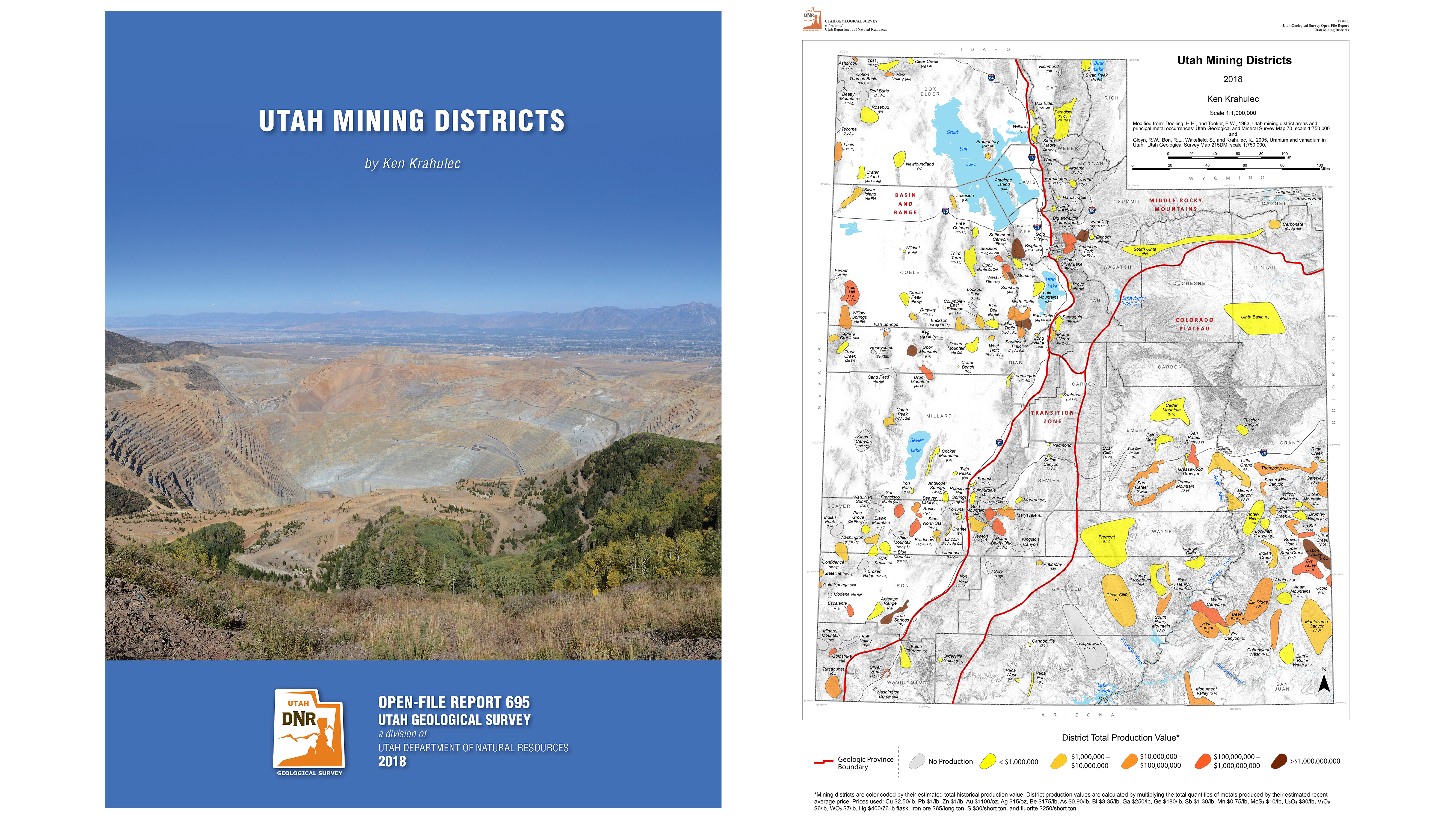
UGS Open-File Report 695
by Ken Krahulec
This report offers a Utah mining districts map and a brief summary of each of Utah’s 185 mining districts. These district summaries include the geologic setting, production significance, major metals produced, recognized ore deposit types, and a discussion on the most important mines in each district. The report also provides a few key references to get the interested reader started on researching more detailed information about each district’s geology and ore deposits.

View Survey Notes here: https://geology.utah.gov/map-pub/survey-notes/
Near Moab, Grand County
Photo by Greg McDonald © 2019
Composed of Jurassic-age Navajo Sandstone, wind-sculpted Corona Arch stands before snow-covered cliffs of the same formation. This arch was formed from the same weathering process and during the same time as the world-famous features in nearby Arches National Park.

![]()
The Utah Geological Survey (UGS) is a division of the Utah Department of Natural Resources. Several specialized programs comprise the UGS: Data Management, Energy & Minerals, Geologic Hazards, Geologic Information & Outreach, Geologic Mapping, Groundwater & Wetlands, and Paleontology.
 © 2019 Jessica Castleton
 Greg McDonald