

Notch Peak, Millard County, Utah
Photographer: Mark Milligan; © 2014
Banded white marble and quartz augen (eyeshaped crystals) in gray argillite, Notch Peak, Millard County.
Notch Peak, Millard County, Utah
Photographer: Mark Milligan; © 2014
Banded white marble and quartz augen (eyeshaped crystals) in gray argillite, Notch Peak, Millard County.

We woke up on the right side of the bedrock today!
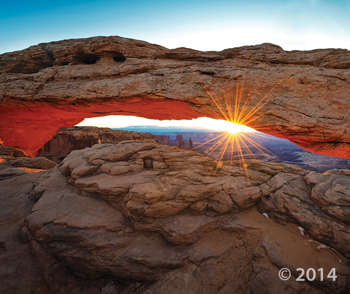
Canyonlands National Park, San Juan County, Utah
Photographer: Gregg Beukelman; © 2014
Mesa Arch, in the Island in the Sky District of Canyonlands National Park, formed as surface water pooled and eventually eroded through bedrock at the mesa’s edge. As the sun rises, its rays reflect off the 800-foot-high cliff of Jurassic-age sedimentary rock below the arch, bathing the bottom of the arch in an orange glow.

We had to turn our air conditioning on this weekend—it’s getting hot! Cool down with this photo while we thaw out our spectacular Utah Geology.
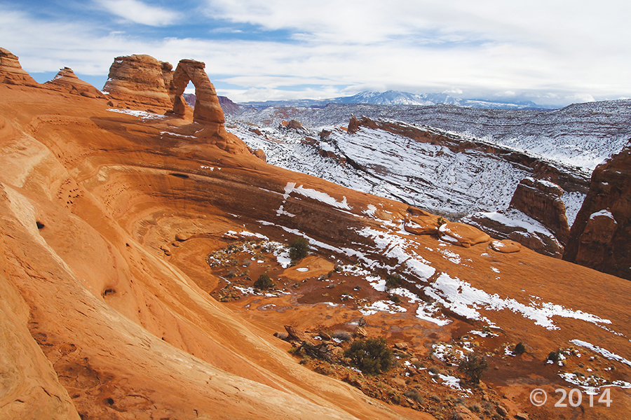
Delicate Arch, Arches National Park, Grand County, Utah
Photographer: Sonja Heuscher; © 2014
livescience.com
In the south-central part of Utah, a 100-mile-long (161 kilometers) formation, dubbed Waterpocket Fold, has created a landscape that is not only spectacular to view but is also a geological treasure for research and study.


Arches National Park, Grand County, Utah
Photographer: Sonja Heuscher; © 2014
The view through North Window arch in The Windows Section of Arches National Park reveals snow-covered sandstone spires and fins of the Jurassic-age Entrada Sandstone. The spires and fins result from weathering and erosion along parallel fractures, or joints, in the rock.


Newspaper Rock petroglyph panel along Indian Creek, San Juan County, Utah
Photographer: Adam Hiscock; © 2014

While this photo is a throwback to colder seasons, we cannot deny the stunning #UtahGeology present. This crisp, cold picture is worth a thousand hand warmers—that’s how the saying goes, right?

Dead Horse Point State Park, San Juan County, Utah
Photographer: Gregg Beukelman; © 2014
The Colorado River loops around the Gooseneck between Dead Horse Point State Park and distant cliffs of the Island in the Sky District of Canyonlands National Park. The river has carved and exposed nearly flat-lying Jurassic to Pennsylvanian-age sedimentary strata of the Colorado Plateau.
Give mom something special this year—show her an adventure in Utah’s beautiful backyard! Goosenecks State Park is easily accessible, and worth a visit.
ksl.com
It might take a poet several weeks to come up with the perfect words to describe the view at Goosenecks State Park.


Needles District, Canyonlands National Park, San Juan County, Utah
Photographer: Adam Hiscock; © 2014

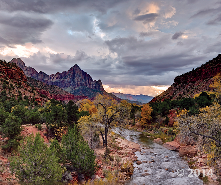
Zion National Park, Washington County, Utah
Photographer: Gregg Beukelman; © 2014
The Watchman (6,545 feet), composed of Jurassic-age Navajo Sandstone, stands guard over the southern entrance to Zion Canyon. The canyon has been carved by the North Fork Virgin River, which has eroded downward thousands of feet through the Navajo and underlying Kayenta and Moenave Formations.
![]()
The Utah Geological Survey (UGS) is a division of the Utah Department of Natural Resources. Several specialized programs comprise the UGS: Data Management, Energy & Minerals, Geologic Hazards, Geologic Information & Outreach, Geologic Mapping, Groundwater & Wetlands, and Paleontology.
1594 West North Temple, Suite 3110
Salt Lake City, Utah 84116
801-537-3300 (phone)
801-537-3400 (fax)
Mailing Address:
PO BOX 146100
Salt Lake City, Utah 84114
Monday through Friday,
8 a.m. to 5 p.m.
![]()