
Utah geology views for days.

Sid’s Mountain Wilderness Study Area, San Rafael Swell, Emery County, Utah
Photographer: Adam Hiscock; © 2015
Utah geology views for days.
Sid’s Mountain Wilderness Study Area, San Rafael Swell, Emery County, Utah
Photographer: Adam Hiscock; © 2015

Take this in over your outdoor daydream today.
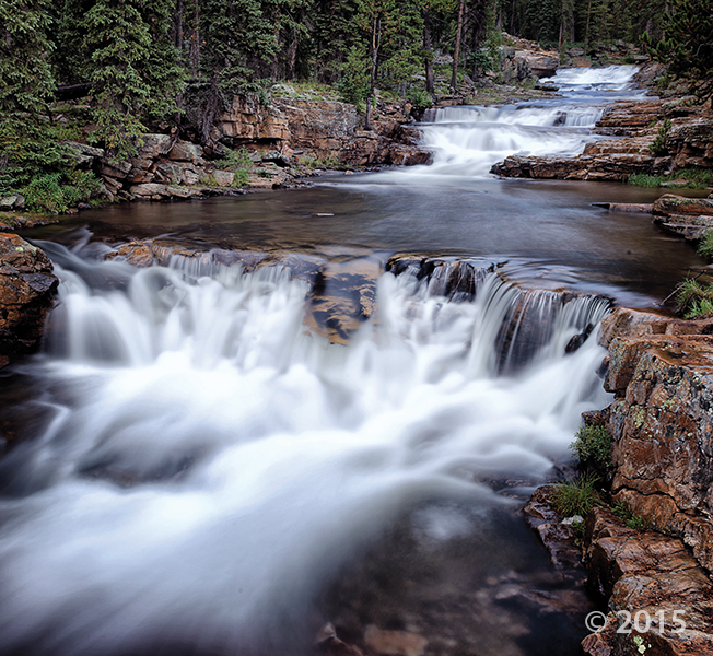
Provo Falls, Summit County, Utah
Photographer: Gregg Beukelman; © 2015
As the Provo River plunges off the south side of the Uinta Mountains along the Mirror Lake Highway, it cascades over innumerable ledges of Precambrian-age Uinta Mountain Group sandstone.
We hope you all had a great and safe Thanksgiving! Who ate so much turkey that they feel like a turkey? I think I do. Here’s a little something to help you kickstart after a long, holiday weekend—
A couple of our geologists here at the UGS helped a team of researchers collect microbialites from Great Salt Lake for the Natural History Museum of Utah. Read more about these living rocks in this great write up.
sltrib.com
As Utah’s Great Salt Lake continues to drop during recent years of drought, something strange and wonderful is coming into focus in the shallows and exposed lake bed.

Wishing everyone a safe and wonderful Thanksgiving from the Utah Geological Survey!
Bluff of Entrada Sandstone at Bullfrog, Kane County, Utah
Photographer: Grant Willis; © 2015
UGS scientists are part of an exciting research team led by the Energy and Geoscience Institute at the University of Utah that will study new techniques for harnessing the Earth’s heat to generate electrical power. Our team will evaluate the establishment of an enhanced underground geothermal project about 10 miles north of Milford, Beaver County. The research is one of five proposals currently funded by the U.S. Department of Energy’s Office of Energy Efficiency and Renewable Energy. Check it out —
Link to the article HERE
It is now up on the EERE Facebook page HERE

Another highlight on the 2016 Calendar of Utah Geology—get yours in time before they’re all gone!
Get them in store at the Utah Natural Resources Map & Bookstore, or online HERE.
deseretnews.com
Some of Utah’s most spectacular displays of geography are once again being showcased in the annual calendar compiled by staff members of the Utah Geological Survey.


Dark Canyon Primitive Area, San Juan County, Utah
Photographer: Diane Menuz; © 2015
The stream in the lower section of Dark Canyon runs reddish brown following heavy morning rain. Sandstone of the Permian-age Cutler Group forms the canyon walls and limestone of the Pennsylvanian-age Honaker Trail Formation is exposed along the stream bed.
Check out the Natural History Museum of Utah’s behind the scenes weekend in pictures. This gallery features an adventure to Great Salt Lake where researchers—including one of our geologists, Tom Chidsey and Michael Vanden Berg—pulled up microbialites for display at the museum.


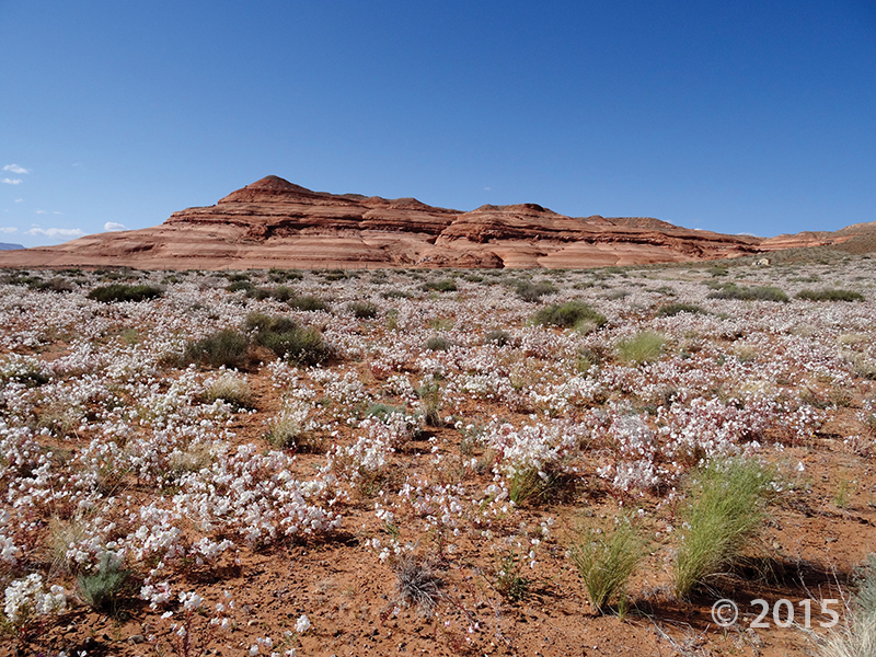
White Rim, Canyonlands National Park, San Juan County, Utah
Photographer: Tyler Knudsen; © 2015


Zion National Park, Washington County, Utah
Photographer: Adam McKean; © 2015
The setting sun illuminates the Jurassic-age Navajo Sandstone cliffs of Cougar Mountain (right) and South Guardian Angel (left) as viewed from Kolob Reservoir Road. Here, the road travels on top of the 220,000- to 310,000-year-old Grapevine Wash lava flow (dark rocks in middle ground).
![]()
The Utah Geological Survey (UGS) is a division of the Utah Department of Natural Resources. Several specialized programs comprise the UGS: Data Management, Energy & Minerals, Geologic Hazards, Geologic Information & Outreach, Geologic Mapping, Groundwater & Wetlands, and Paleontology.