 Wah Wah Mountains, Millard County, Utah
Photographer: Tyler Knudsen
Nearly 1,000 feet of the Tunnel Spring Tuff, erupted from a nearby caldera about 35 million years ago, makes up Crystal Peak in the Wah Wah Mountains, Millard County.
Wah Wah Mountains, Millard County, Utah
Photographer: Tyler Knudsen
Nearly 1,000 feet of the Tunnel Spring Tuff, erupted from a nearby caldera about 35 million years ago, makes up Crystal Peak in the Wah Wah Mountains, Millard County.
 Happy New Year, everyone!! Here’s a beautiful photo to start out the new year.
House Range, Millard County, Utah
Photographer: Tyler Knudsen
Sawtooth Mountain, which exhibits desert varnish and spheroidal weathering along joints, is a granitic intrusion in the House Range, Millard County.
 Here is a gorgeous photo to the end of another great year. We wish all of our geo friends a safe and wonderful New Year. See you in 2014!
Henry Mountains, Garfield County, Utah
Photographer: Ken Krahulec
The “dome” character of a laccolith, where the sedimentary rock layers are tilted upward on the mountain flanks, is evident at Mount Ellsworth in the Henry Mountains, Garfield County.
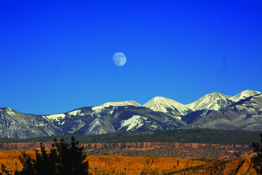
La Sal Mountains, Grand and San Juan Counties, Utah
Photographer: Jay Hill
The La Sal Mountains, near Moab in southeastern Utah, are laccoliths formed when upwelling magma intruded into and bulged the overlying sedimentary rock layers upward. The magma did not reach the surface, but subsequent erosion of the softer sedimentary rocks exposed the peak-forming igneous rocks that rise above the surrounding landscape.
 Grand Staircase–Escalante National Monument, Garfield County, Utah
Photographer: Rich Emerson
Cottonwood trees in a slot canyon, Rattle-snake Bench, Grand Staircase–Escalante National Monument, Garfield County.
 The Narrows, Zion National Park, Washington County, Utah
Photographer: Tyler Knudsen
Small waterfall framed by the constricting walls of Navajo Sandstone in The Narrows, Zion National Park, Washington County.
 From everyone at the Utah Geological Survey, we hope you have a Merry Christmas that rocks!
Paria Canyon–Vermilion Cliffs Wilderness Area, Kane County, Utah
Photographer: Tyler Knudsen
Morning sunlight illuminates water-sculpted walls of the Buckskin Gulch slot canyon. Cut deeply into Jurassic-age Navajo Sandstone, the Buckskin’s slot ranges from 5 to 25 feet wide and 100 to 500 feet high for 12 miles, making it the longest slot canyon in the world.
 We send all of our geo friends good tidings on this Christmas Eve!
Bear Lake, Rich County, Utah
Photographer: Jim Davis
Jurassic-age Nugget Sandstone is wave-weathered into smooth, rounded forms on the east shore of Bear Lake, Rich County.
 Capitol Reef National Park, Wayne County, Utah
Photographer: Tyler Knudsen
Sheer walls of Jurassic-age Wingate Sandstone loom over a barn and orchards of historic Fruita in Capitol Reef National Park, Wayne County.
 Abajo Mountains, San Juan County, Utah
Photographer: Grant Willis
Blocky sandstone ledge deposited in an oasis-like setting between ancient sand dunes forms a resistant cap over beds of the Jurassic-age Navajo Sandstone. Chippean Rocks west of the Abajo Mountains, San Juan County.
![]()
The Utah Geological Survey (UGS) is a division of the Utah Department of Natural Resources. Several specialized programs comprise the UGS: Data Management, Energy & Minerals, Geologic Hazards, Geologic Information & Outreach, Geologic Mapping, Groundwater & Wetlands, and Paleontology.