
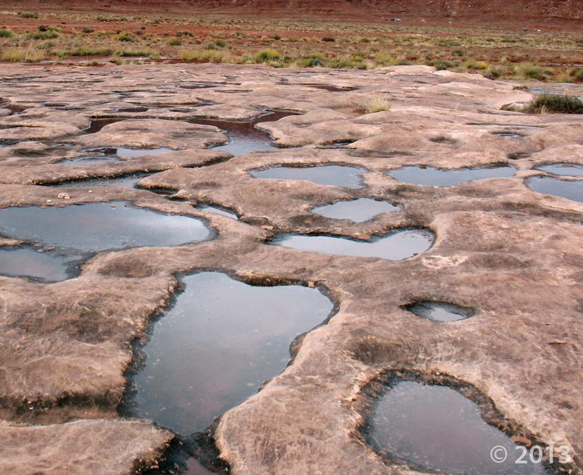
Canyonlands National Park, San Juan County, Utah
Photographer: Don DeBlieux; © 2013
Water-filled potholes in the White Rim Sandstone, Canyonlands National Park, San Juan County.
Canyonlands National Park, San Juan County, Utah
Photographer: Don DeBlieux; © 2013
Water-filled potholes in the White Rim Sandstone, Canyonlands National Park, San Juan County.

Not only does Utah’s geology make for stunning landscapes, the textures are pretty great too!
Paria Plateau, Kane County, Utah
Photographer: Tyler Knudsen; © 2013
Liquefaction features in Navajo Sandstone, Paria Plateau, Kane County.
November is here! We hope you all had a great and safe Halloween. It won’t be long before Christmas is on the horizon; treat family, friends, or even yourself to a  whole year gorgeous Utah geology. It features photos of Utah’s stunning geology taken by UGS employees. Be sure to stop by the Utah Natural Resources Map & Bookstore or ONLINE HERE to buy yours today!
deseretnews.com
Each year, a fierce but friendly competition delivers some of the most stunning photographs of Utah scenery — and the best examples are compiled in a calendar available for purchase.
UGS paleontologists Jim Kirkland and Don DeBlieux spent last week assisting a crew from Utah State Parks and the Escalante Petrified Forest State Park in moving a large petrified tree to the park for display. The park received permission from the Bureau of Land Management (BLM) to move the tree from land they manage just outside the town of Escalante, and they called in UGS paleontologists to consult with and oversee the move. Several pieces of heavy equipment were needed to lift the log, which was already separated into sections, onto a flatbed truck for the several-mile drive to the park. Eighteen sections were moved, including the base of the tree that was estimated to weigh over 2 tons, and lifted back into place in the sand-filled concrete enclosure that had been constructed to house the tree. The park is known for its large number of petrified logs eroding out of the 150-million-year-old Morrison Formation rocks. These logs are found on a plateau above the park entrance that can only be accessed by a fairly rugged hike, so not all visitors will have the time or the ability to see them. By having a large tree on display near the visitors center, many more people, including those with physical challenges, will be able to view and learn about the fossils found in this region. The cooperation of the BLM and State Parks for the benefit of Utah citizens and visitors was well exemplified during this project.
 Incised petroglyphs, Canaan Gap, Washington County, Utah
Photographer: Tyler Knudsen; © 2013
Check out this read for your mid-morning break—last week Utah State Paleontologist James Kirkland and UGS Paleontologist Don DeBlieux led the move of a 150-million-year-old petrified tree from nearby BLM land to the visitor center in Escalante Petrified Forest State Park. Stay tuned as we compile footage from the move!
sltrib.com
Escalante Petrified Forest State Park has one of the best collections of petrified wood in a natural setting in the country. But not everyone who stops at the park has the time, or the desire, to make a relatively short hike to see the collection.
 Grand Staircase–Escalante National Monument, Garfield County, Utah
Photographer: Michael Vanden Berg; © 2013
Iron concretions from the Navajo Sandstone, Grand Staircase–Escalante National Monument, Garfield County
With Earth Science Week ending, we’ve compiled and created a little video recapping a successful #EarthScienceWeek here at the UGS! The Utah Geological Survey hosts hands-on activities for school groups (usually 4th and 5th graders) during October. Check it out!
 Earth Science Week 2014 at the Utah Geological Survey wrapped up last Thursday. Nearly 900 students, teachers, and parents, rotated through science stations at the Utah Core Research Center to experience 90 minutes of hands-on Earth science. The UGS was greatly assisted by dozens of scientist volunteers including people from the Bureau of Land Management, National Weather Service, North American Exploration, Paul Anderson Consulting, Rockhounders Outreach for Community Knowledge, University of Utah, Utah Department of Environmental Quality, Utah Office of Energy Development, Utah Valley University, Utah Water Resources, Utah Division of Oil, Gas, & Mining, Utah Friends of Paleontology, and Weber State University.

Check out more photos on our Facebook HERE. Like us on FACEBOOK or Follow us on TWITTER to keep up to date on our latest happenings!
 Buckskin Gulch, Kane County, Utah
Photographer: Valerie Davis; © 2013
Canyon walls of Buckskin Gulch, Kane County.
![]()
The Utah Geological Survey (UGS) is a division of the Utah Department of Natural Resources. Several specialized programs comprise the UGS: Data Management, Energy & Minerals, Geologic Hazards, Geologic Information & Outreach, Geologic Mapping, Groundwater & Wetlands, and Paleontology.