Tag Archive for: Notch Peak

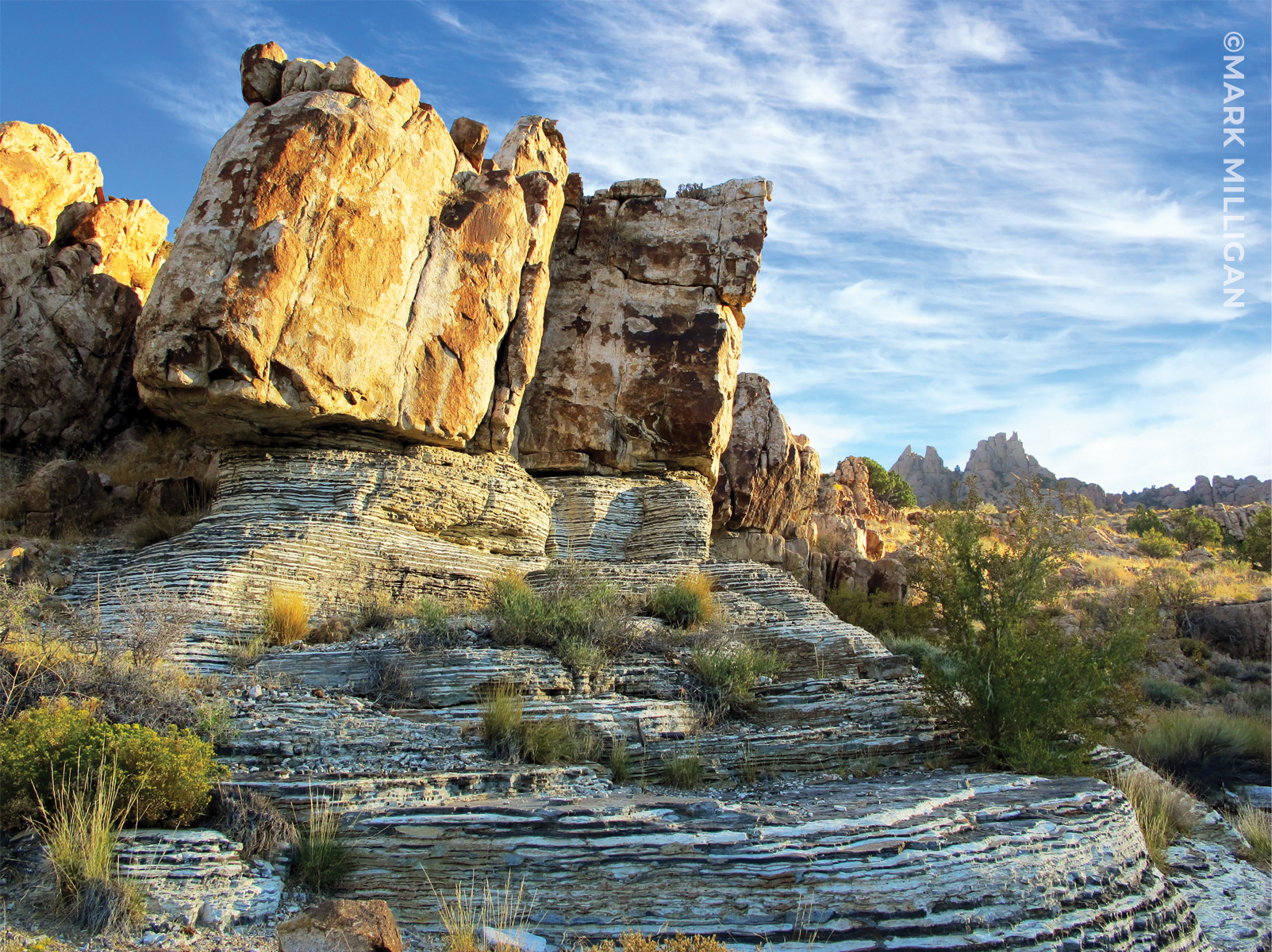
Near the base of Notch Peak, pink Jurassic-age granite intrudes much older thinly bedded gray argillite and white marble of the Cambrian-age Marjum Formation. Deep in the Earth’s crust 170 million years ago, high heat and fluids from the granite metamorphosed the surrounding rock, turning limestone into marble and shale into argillite.

House Range, Millard County, Utah. Photo by Mark Milligan.

Banded white marble and quartz augen (eyeshaped crystals) in gray argillite, Notch Peak, Millard County. Photographer: Mark Milligan; © 2014

POTD 6-16-15 Notch Peak Mineral Rock Argillite

Notch Peak, Millard County, Utah
Photographer: Mark Milligan; © 2014

Banded white marble and quartz augen (eyeshaped crystals) in gray argillite, Notch Peak, Millard County.

heraldextra.com

Hidden away in the House Range 50 miles west of Delta, nearly to the Nevada border, is one of the highest cliffs in North America with a vertical drop of 2,200 feet!

READ MORE

House Range, Millard County, Utah.
Photographer: Michael Vanden Berg

The Notch Peak quartz monzonite (foreground) was magma during Jurassic times and intruded into Cambrian limestone and dolomite hundreds of millions of years after the Cambrian rock was deposited as sediment in tropical seas.


Notch Peak, House Range, Millard County, Utah
Photographer: Michael Vanden Berg

Abundant trilobite fossils, including  Elrathia kingi shown here, can be found  within the Wheeler Shale east of Notch Peak in the House Range.

Many of the dry desert peaks of western Utah tell a story of shallow tropical seas. As much as 500 million years of deep burial, uplift, and erosion have changed layers of organic mud to cliffs and ledges of layered limestone. Closer inspection reveals abundant fossils, evidence of ancient sea life.

Notch Peak National Natural Landmark, House Range, Millard County, Utah
Photographer: Matt Affolter

Cambrian- to Ordovician-aged carbonate rocks (limestone and dolomite) make up Notch Peak, where a 2,200-foot cliff (possibly the tallest carbonate cliff in North America) leads to a deep canyon on the west side of the peak. Pink, Jurassic-aged granite is exposed at the foot of the mountain, and scattered deposits of white, clayey marl deposited in Lake Bonneville during the late Pleistocene are present on the valley floor.

The enormity and vastness of the cliff forming the north face of Notch Peak is difficult to describe. Standing near the cliff’s base and looking up is awe inspiring. The view while standing at the top and looking over the edge? I would not know as I was on my hands and knees, too fearful to stand and look over the edge at one of the greatest vertical drops in the contiguous U.S.
Reported estimates of the cliff’s actual height vary significantly from under 2,000 feet to over 4,500 feet, which is likely due to differences in defining where the base of the cliff starts. Photogrammetry (measurements from digital stereoscopic photographs), verified with a paper 7.5′ topographic map, suggests the cliff has an uninterrupted near-vertical drop of over 1,500feet. The addition of cliff below a small bench 50 to 100 yards wide increases the distance to approximately 2,250 feet. Adding a portion of the very steep base of the sheer drop  increases the distance to nearly 2,900 feet.