Tag Archive for: Green River

 © Jen Miller
Along the Green River, Dinosaur National Monument, Uintah County, Utah. Photo by Jen Miller.

 © Emily Kleber
Nine Mile Canyon Road, Carbon County, Utah. Photo by Emily Kleber.
Cliffs of deltaic sandstone in the Eocene-age Green River Formation tower over Nine Mile Canyon, an area rich in geologic and human history.


Hey friends, we’ve finally made way with our new website! Visit geology.utah.gov to see our new look. Though, as most technical endeavors, we’ve encountered some difficulties. Switching the URLs erased our subscription list, and those who subscribed to our “New Blog,” you will have to re-subscribe. We apologize for the inconvenience, but we hope you’ll forgive us when you see this pretty picture of Utah geology.
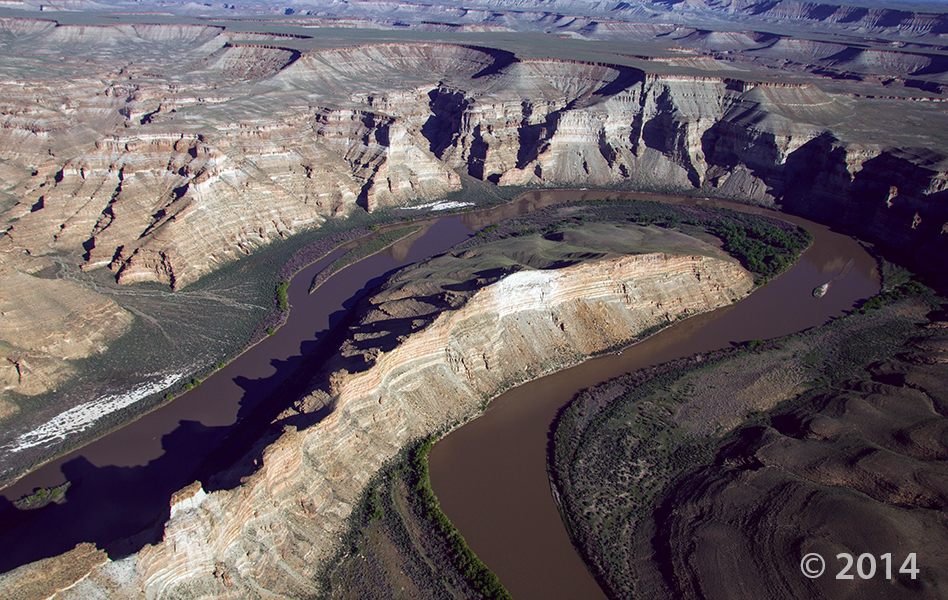
Desolation Canyon, Uintah County, Utah
Photographer: Adam Hiscock; © 2014
The Green River forms a dramatic “gooseneck” near Sand Wash in upper Desolation Canyon. The river has incised into rocks of the Douglas Creek and Parachute Creek Members of the Tertiary-age Green River Formation, which comprises sediments that accumulated in ancient Lake Uinta.
 After perusing through some of our old pictures, this gem showed up for today’s #throwbackthursday geology/history lesson. This old postcard shows off the geyser in Woodside, UT which is now merely a railroad ghost town (and a llama) along Highway 6 about 25 miles north of Green River. Like Crystal Geyser, the geyser in Woodside is also carbon dioxide driven and erupts from an old well. #tbt
Perhaps some of you remember KSL’s article of the town’s sale. Read the article HERE.
A deeper look at one of our recent “Spot the Rock” sights, Crystal Geyser.
ksl.com
One of Utah’s most unusual tourist attractions is dying.
 Canyonlands National Park, San Juan and Wayne Counties, Utah
Photographer: Rich Emerson; © 2012
Uplift of the Colorado Plateau has caused the Green River to entrench its meandering path into the relatively soft rocks of the Permian-age Organ Rock Shale. At Soda Springs Basin, vertical cliffs of the more-resistant White Rim Sandstone cap the Organ Rock Shale 400 feet above the river.
 Green River, Uintah County, Utah
Photographer: Stefan Kirby; ©2011
Morning light on layered rocks of the Tertiary-age Green River Formation north of Desolation Canyon along the Green River.
 Green River, San Rafael Desert, Emery County, Utah
Photographer: Tom Chidsey
An ancient, meandering river channel composed of resistant sandstone in the Cedar Mountain Formation now stands 100 feet higher than the surrounding, less resistant siltstone and shale landscape southwest of Green River, San Rafael Desert, Emery County.

Crystal Geyser, Green River, Grand County, Utah.
Photographer: Taylor Boden
Colorful travertine (calcium carbonate) is deposited around cold-water, carbon-dioxide-driven Crystal Geyser.
Tag Archive for: Green River
Along the Green River, Dinosaur National Monument, Uintah County, Utah. Photo by Jen Miller.
Nine Mile Canyon Road, Carbon County, Utah. Photo by Emily Kleber.
Cliffs of deltaic sandstone in the Eocene-age Green River Formation tower over Nine Mile Canyon, an area rich in geologic and human history.
Hey friends, we’ve finally made way with our new website! Visit geology.utah.gov to see our new look. Though, as most technical endeavors, we’ve encountered some difficulties. Switching the URLs erased our subscription list, and those who subscribed to our “New Blog,” you will have to re-subscribe. We apologize for the inconvenience, but we hope you’ll forgive us when you see this pretty picture of Utah geology.
Desolation Canyon, Uintah County, Utah
Photographer: Adam Hiscock; © 2014
The Green River forms a dramatic “gooseneck” near Sand Wash in upper Desolation Canyon. The river has incised into rocks of the Douglas Creek and Parachute Creek Members of the Tertiary-age Green River Formation, which comprises sediments that accumulated in ancient Lake Uinta.
After perusing through some of our old pictures, this gem showed up for today’s #throwbackthursday geology/history lesson. This old postcard shows off the geyser in Woodside, UT which is now merely a railroad ghost town (and a llama) along Highway 6 about 25 miles north of Green River. Like Crystal Geyser, the geyser in Woodside is also carbon dioxide driven and erupts from an old well. #tbt
Perhaps some of you remember KSL’s article of the town’s sale. Read the article HERE.
A deeper look at one of our recent “Spot the Rock” sights, Crystal Geyser.
ksl.com
One of Utah’s most unusual tourist attractions is dying.
Canyonlands National Park, San Juan and Wayne Counties, Utah
Photographer: Rich Emerson; © 2012
Uplift of the Colorado Plateau has caused the Green River to entrench its meandering path into the relatively soft rocks of the Permian-age Organ Rock Shale. At Soda Springs Basin, vertical cliffs of the more-resistant White Rim Sandstone cap the Organ Rock Shale 400 feet above the river.
Green River, Uintah County, Utah
Photographer: Stefan Kirby; ©2011
Morning light on layered rocks of the Tertiary-age Green River Formation north of Desolation Canyon along the Green River.
Green River, San Rafael Desert, Emery County, Utah
Photographer: Tom Chidsey
An ancient, meandering river channel composed of resistant sandstone in the Cedar Mountain Formation now stands 100 feet higher than the surrounding, less resistant siltstone and shale landscape southwest of Green River, San Rafael Desert, Emery County.
Crystal Geyser, Green River, Grand County, Utah.
Photographer: Taylor Boden
Colorful travertine (calcium carbonate) is deposited around cold-water, carbon-dioxide-driven Crystal Geyser.
LEARN MORE ABOUT THE UTAH GEOLOGICAL SURVEY
![]()
The Utah Geological Survey (UGS) is a division of the Utah Department of Natural Resources. Several specialized programs comprise the UGS: Data Management, Energy & Minerals, Geologic Hazards, Geologic Information & Outreach, Geologic Mapping, Groundwater & Wetlands, and Paleontology.
QUICK LINKS
CONTACT INFORMATION
Staff Directory1594 West North Temple, Suite 3110
Salt Lake City, Utah 84116
801-537-3300 (phone)
801-537-3400 (fax)
Mailing Address:
PO BOX 146100
Salt Lake City, Utah 84114
HOURS
Monday through Friday,8 a.m. to 5 p.m.