
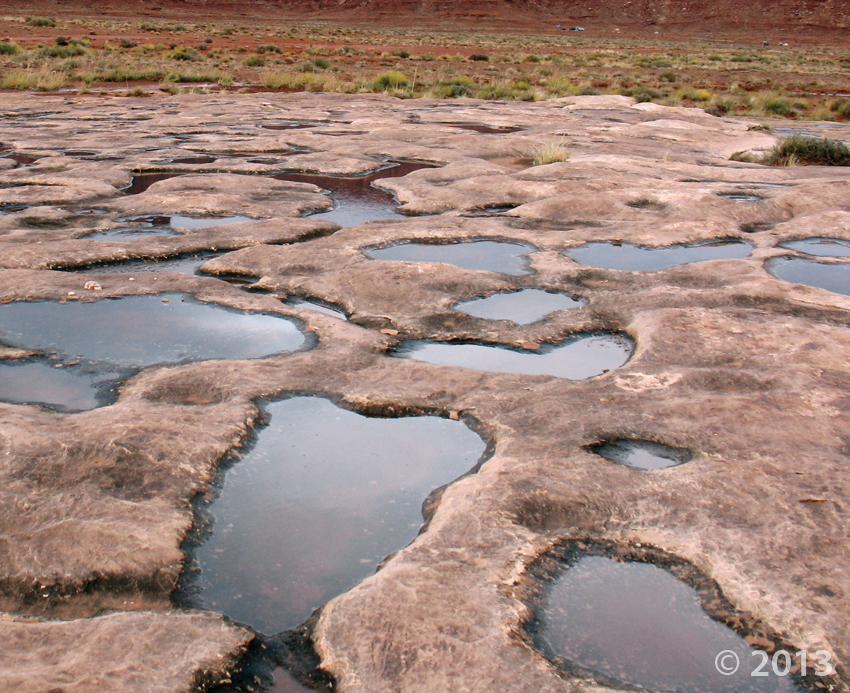
Canyonlands National Park, San Juan County, Utah
Photographer: Don DeBlieux; © 2013
Water-filled potholes in the White Rim Sandstone, Canyonlands National Park, San Juan County.
Canyonlands National Park, San Juan County, Utah
Photographer: Don DeBlieux; © 2013
Water-filled potholes in the White Rim Sandstone, Canyonlands National Park, San Juan County.

Not only does Utah’s geology make for stunning landscapes, the textures are pretty great too!
Paria Plateau, Kane County, Utah
Photographer: Tyler Knudsen; © 2013
Liquefaction features in Navajo Sandstone, Paria Plateau, Kane County.
davisclipper.com
An earthquake is due to hit in Davis and Salt Lake counties sometime between Nov. 3-6 and the National Guard, Davis Hospital and Medical Center, fire departments and utilities are already planning what they will do when the big one hits.
As a Halloween special, we’re taking you beyond Utah and overseas to London, England’s cemeteries. How is geology shaping and evolving those old headstones? Read more in this great piece to find out!
www.ucl.ac.uk
 Incised petroglyphs, Canaan Gap, Washington County, Utah
Photographer: Tyler Knudsen; © 2013
Cooler weather is on its way, so we’ve got a cool “Glad You Asked” article to compliment the changing seasons! It’s a beautiful time of the year to get out into Utah’s geology. Maybe some of you have noticed these groovy rocks out on your outdoor adventures. What are those grooves in the rocks, and how did they get that way?
Read more about Glacial Striations and Slickensides HERE!
 Grand Staircase–Escalante National Monument, Garfield County, Utah
Photographer: Michael Vanden Berg; © 2013
Iron concretions from the Navajo Sandstone, Grand Staircase–Escalante National Monument, Garfield County
colored-sand-and-unity-sand-ceremony.com
The Earth formed more than 4.5 billion years ago. As the planet cooled, a new solid crust formed. The crust is only 8 kilometers thick under the oceans (oceanic crust) and about 32 kilometers thick under the continents (continental crust).
A great read for the morning. One example of technological progression and its contribution to our greater knowledge!
phys.org
A blend of photos and technology takes a new twist on studying cliff landscapes and how they were formed. Dylan Ward, a University of Cincinnati assistant professor of geology, will present a case study on this unique technology application at The Geological Society of America’s Annual Meeting & Exposition. The meeting takes place Oct. 19-22, in Vancouver.
 Earth Science Week 2014 at the Utah Geological Survey wrapped up last Thursday. Nearly 900 students, teachers, and parents, rotated through science stations at the Utah Core Research Center to experience 90 minutes of hands-on Earth science. The UGS was greatly assisted by dozens of scientist volunteers including people from the Bureau of Land Management, National Weather Service, North American Exploration, Paul Anderson Consulting, Rockhounders Outreach for Community Knowledge, University of Utah, Utah Department of Environmental Quality, Utah Office of Energy Development, Utah Valley University, Utah Water Resources, Utah Division of Oil, Gas, & Mining, Utah Friends of Paleontology, and Weber State University.

Check out more photos on our Facebook HERE. Like us on FACEBOOK or Follow us on TWITTER to keep up to date on our latest happenings!
![]()
The Utah Geological Survey (UGS) is a division of the Utah Department of Natural Resources. Several specialized programs comprise the UGS: Data Management, Energy & Minerals, Geologic Hazards, Geologic Information & Outreach, Geologic Mapping, Groundwater & Wetlands, and Paleontology.