Tag Archive for: geological

cbsnews.com

Monument Valley is probably best known to many Americans from having been seen in more Western movies than any other location in the U.S. Most visitors to Monument Valley are immediately taken back to old John Ford films, including “The Searchers,” “Stagecoach,” and “She Wore a Yellow Ribbon.”

READ MORE

Sunset on Gooseberry Mesa shines golden light on cliffs of Triassic-age Shinarump Conglomerate and the underlying slope-forming Moenkopi Formation. White cliffs and peaks in the distance are thrones and temples of Zion National Park, formed of Jurassic-age Navajo Sandstone. Gooseberry Mesa, Washington County, Utah Photographer: J. Lucy Jordan; © 2016

POTD 5-31-16 Washington County

Gooseberry Mesa, Washington County, Utah
Photographer: J. Lucy Jordan; © 2016

Sunset on Gooseberry Mesa shines golden light on cliffs of Triassic-age Shinarump Conglomerate and the underlying slope-forming Moenkopi Formation. White cliffs and peaks in the distance are thrones and temples of Zion National Park, formed of Jurassic-age Navajo Sandstone.

Lake Powell’s Gunsight Bay as seen from Alstrom Point, Kane County. Alstrom Point, Kane County, Utah Photographer: Marshall Robinson; © 2016

5-24-16

Alstrom Point, Kane County, Utah
Photographer: Marshall Robinson; © 2016

Lake Powell’s Gunsight Bay as seen from Alstrom Point, Kane County.

Just above its confluence with the Dirty Devil River, Happy Canyon deeply and abruptly cuts and sculpts the White Rim Sandstone of the Permian-age Cutler Formation. Happy Canyon, Garfield County, Utah Photographer: Gregg Beukelman; © 2016

POTD 5-17-16 Happy Canyon Garfield County

Happy Canyon, Garfield County, Utah
Photographer: Gregg Beukelman; © 2016

Just above its confluence with the Dirty Devil River, Happy Canyon deeply and abruptly cuts and sculpts the White Rim Sandstone of the Permian-age Cutler Formation.

Wasatch Range east of Layton, Davis County, Utah Photographer: Ken Krahulec; © 2016

POTD 5-10-16 Wasatch Range Davis County

Wasatch Range east of Layton, Davis County, Utah
Photographer: Ken Krahulec; © 2016

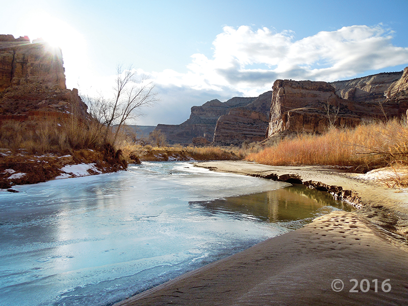
Short days and low winter sun cause ice to form along the San Rafael River where it cuts through the west flank of the San Rafael Swell. The 1,100-foot-deep canyon exposes the Jurassic-Triassic-age Glen Canyon Group along the cliffs and ledges of the canyon walls. Little Grand Canyon of the San Rafael River, Emery County, Utah Photographer: Zach Anderson; © 2016

POTD 5-3-16 San Rafael River Emery County

Little Grand Canyon of the San Rafael River, Emery County, Utah
Photographer: Zach Anderson; © 2016

Short days and low winter sun cause ice to form along the San Rafael River where it cuts through the west flank of the San Rafael Swell. The 1,100-foot-deep canyon exposes the Jurassic-Triassic-age Glen Canyon Group along the cliffs and ledges of the canyon walls.

Lower Bells Canyon Reservoir and glacially sculpted Bells Canyon, Wasatch Range, Salt Lake County. Bells Canyon, Wasatch Range, Salt Lake County, Utah Photographer: Jim Davis; © 2015

POTD 4-26-16 Bells Canyon Salt Lake County

Bells Canyon, Wasatch Range, Salt Lake County, Utah
Photographer: Jim Davis; © 2015

Lower Bells Canyon Reservoir and glacially sculpted Bells Canyon, Wasatch Range, Salt Lake County.

Small cave-like features called tafoni pockmark the walls of a slot canyon in the southern San Rafael Swell, Emery County. San Rafael Swell, Emery County, Utah Photographer: Mark Milligan; © 2015

An afternoon escape—

POTD 4-19-16 San Rafael Swell

San Rafael Swell, Emery County, Utah
Photographer: Mark Milligan; © 2015

Small cave-like features called tafoni pockmark the walls of a slot canyon in the southern San Rafael Swell, Emery County.

Pinnacles eroded from Tertiary-age lava flow breccia along State Route 20, Garfield County.

POTD 4-12-16 lava flow Garfield County

State Route 20, Garfield County, Utah
Photographer: Bob Biek; © 2015

Pinnacles eroded from Tertiary-age lava flow breccia along State Route 20, Garfield County.


Little Deer Creek cascades over sandstone ledges of the Precambrian-age Hades Pass unit of the Uinta Mountain Group into Cataract Gorge on the Duchesne River, Duchesne County. Duchesne River, Duchesne County, Utah Photographer: Rich Emerson; © 2015

POTD 4-5-16 Duchesne County Waterfall

Duchesne River, Duchesne County, Utah
Photographer: Rich Emerson; © 2015

Little Deer Creek cascades over sandstone ledges of the Precambrian-age Hades Pass unit of the Uinta Mountain Group into Cataract Gorge on the Duchesne River, Duchesne County.