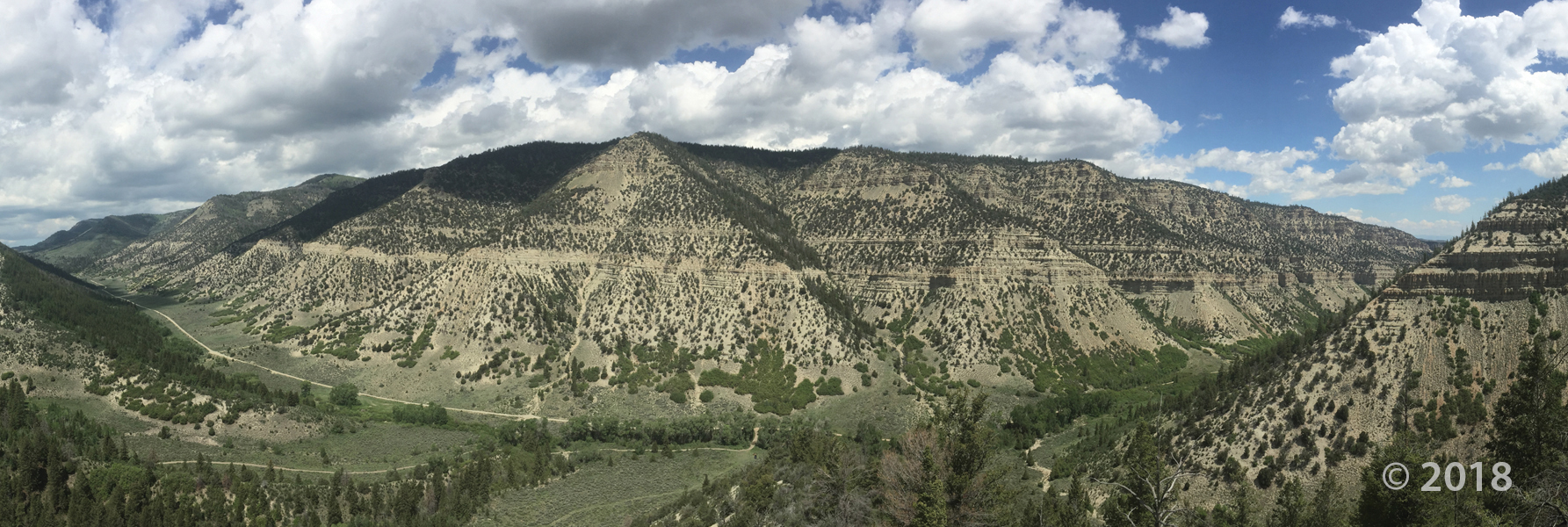
Timber Canyon, Duchesne County
Photographer: Ryhan Sempler © 2018
Timber Canyon, Duchesne County
Photographer: Ryhan Sempler © 2018
Bonnie Lake, Uinta Mountains, Duchesne County
Photographer: Ben Erickson © 2017


Duchesne River, Duchesne County, Utah
Photographer: Rich Emerson; © 2015
Little Deer Creek cascades over sandstone ledges of the Precambrian-age Hades Pass unit of the Uinta Mountain Group into Cataract Gorge on the Duchesne River, Duchesne County.

By: Douglas A. Sprinkel
The interim geologic map of the east part of the Duchesne 30’x60′ quadrangle (year 3) consists of eighteen 7.5 minute quadrangles and is the third year of a multi-year project to map and compile the geology of this quadrangle. The quadrangle is located mostly in the western Uinta basin, with the northwest corner located along the southwest flank of the Uinta Mountains but the area mapped is centered on Roosevelt, Utah. The map area includes a variety of surficial deposits that range from historic to lower Pleistocene piedmont alluvium, stream alluvium, and glacial deposits. Bedrock map units include members of the Duchesne River formation, the upper two members of the Uinta Formation, and upper two members of the Green River Formation. Members of the Duchesne River Formation are (in descending order) Starr Flat, Lapoint, Dry Gulch Creek, and Brennan Basin. Members of the Uinta Formation are (in descending order) member C and member B. The sandstone and limestone facies and the saline facies are of the Green River Formation are exposed south of U.S. Highway 40 and south-southwest of Duchesne, Utah. Structural features include the axis of the Uinta Basin syncline (and associated folds), the Uinta Basin-Mountain boundary fault zone located in the northern part of the map area with evidence of movement in the Quaternary, and the Duchesne fault zone located in the southern part of the map area. The Duchesne 30’x60′ quadrangle also contains an array of geologic resources including minerals, phosphate, sand and gravel, and gilsonite, but energy resources are the most significant with the giant Altamont-Bluebell and Monument Butte fields included in the quadrangle.

By: Esther M. Kingsbury-Stewart, Paul K. Link, Carol M. Dehler, and Shannon L. Osterhout
The Kings Peak 7.5-minute quadrangle straddles the crest of the Uinta Mountains in the High Uinta Wilderness Area and contains Kings Peak, Utah’s highest point. The peaks and cliffs are comprised of the newly formalized formations of the Neoproterozoic (late Precambrian) Uinta Mountain Group, which is about 770 to 742 million years old. The basins, basin margins, and cirques are filled with glacial deposits of Smith Fork age-32,000 to 14,000 years ago (Pinedale equivalent). The quadrangle also straddles the anticline crest of the Uinta arch. A series of igneous dikes are exposed in the quadrangle. These dikes cut formations of the Uinta Mountain Group are about 450 to 490 million years old.
sltrib.com
The Stonegate subdivision seems like a great place to settle down and raise kids. But a dank secret lurks under its sprawling lawns.
 By: Douglas A. Sprinkel
This CD contains the geologic map at 1:50,000 scale and a 19-page booklet, both in PDF format. The map covers six 7.5-minute quadrangles in the eastern part of the Duchesne 30’x 60′ quadrangle. The quadrangle is located mostly in the western Uinta Basin, with the northwest corner located along the southwest flank of the Uinta Mountains but the area mapped is centered on Roosevelt, Utah. The map area includes surficial deposits that range from historic to lower Pleiestocene piedmont alluvium, stream alluvium, and glacial deposits. Bedrock map units include the Duchesne River and Uinta Formations. Structural features include the axis of the Uinta Basin syncline (and associated folds), the basin boundary fault zone in the northern part of the map area, and the Duchesne fault zone in the southern part of the map area. The Duchesne 30’x 60′ quadrangle also contains an array of geologic resources including minerals, phosphate, sand and gravel, and gilsonite, but energy resources are the most significant with the giant Altamont-Bluebell and Monument Butte fields located in the quadrangle.
 Who’s ready to get back out into that beautiful Utah Spring scenery?
Scudder Lake, Uinta Mountains, Duchesne County, Utah
Photographer: Ken Krahulec; © 2012
Scudder Lake in the glaciated Uinta Mountains, Duchesne County.
 Mirror lake, Uinta Mountains, Duchesne County, Utah
Photographer: Ken Krahulec
Mirror Lake nestles among 11,000-foot peaks of the western Uinta Mountains. The rocks of the Uintas, consisting largely of sandstone and shale of the Precambrian-age Uinta Mountain Group, contain microscopic bacteria nearly 800 million years old that likely represent Utah’s oldest fossils.

Dollar Lake, High Uintas Wilderness, Duchesne County, Utah
Photographer: Mike Hylland
To the south of Dollar Lake in the Uinta Mountains, cliffs of Precambrian-age sedimentary strata rise abruptly at the head of the Henrys Fork basin. The leftmost peak lit by the morning sun is Utah’s highest mountain, Kings Peak (13,528 feet), which was named for Clarence King, first director of the U.S. Geological Survey.
![]()
The Utah Geological Survey (UGS) is a division of the Utah Department of Natural Resources. Several specialized programs comprise the UGS: Data Management, Energy & Minerals, Geologic Hazards, Geologic Information & Outreach, Geologic Mapping, Groundwater & Wetlands, and Paleontology.