
2026 Calendar of Utah Geology
Media Inquiry:
Ben Dlin, Utah Geological Survey–PIO, 385.508.8162 – bdlin@utah.gov

PRESS RELEASE: Utah Geological Survey Unveils New Calendar, A Tale of Statewide Pride
Salt Lake City, Utah (December 4, 2025)—The Utah Geological Survey (UGS) today announced the launch of its annual calendar, a stunning photographic tribute to Utah’s breathtaking and diverse geology. This year’s calendar showcases natural wonders from every corner and provides a unique glimpse into the scientific work of the UGS, a division of the Utah Department of Natural Resources. The photos were captured by UGS scientists who are dedicated to decoding the beautiful and unique geology of Utah.
The calendar, a beloved tradition for nearly two decades, features a curated collection of photographs taken by UGS staff in the field. From the iconic red rock canyons of southern Utah to the majestic alpine peaks of the Wasatch and the expansive basins and ranges of the west desert, the photos serve as a reminder of the state’s diverse geology. Each month features a new, awe-inspiring image, accompanied by a description that provides a deeper understanding of the geological forces that shaped the landscape.
“Every photograph in this calendar is a mile marker of our work across this magnificent state,” said Darlene Batatian, UGS Director. “It celebrates the special moments we experience while we work: the sunrises we catch over a newly mapped fault line in Cache Valley or the dust we kick up mapping mineral deposits near the Arizona border. Our geologists are trekking across nearly every mile of every Utah county, from the high Uintas to the red-rock desert. We aren’t just mapping rocks; we are also mapping the foundation—the water, energy, minerals and hazards—that supports every Utahn’s future. This calendar presents our most beautiful photos, but it’s also the story of how UGS is supporting the prosperity of this whole state.”

Red Castle, Uinta Mountains, Summit County Photographer: Ryan Gall Red Castle is a 12,676-foot-high feature in the High Uintas Wilderness. The prominent cliffs are composed of pebbly arkosic sandstone, siltstone, and shale assigned to the Red Castle unit of the middle Proterozoic-age Uinta Mountain Group.
 rocks making up the eastern cliff face of the House Range. With approximately 2,900 feet of vertical rise, the impressive north face of Notch Peak is among the tallest cliffs in the U.S., and is the highest carbonate rock cliff in North America.")
Notch Peak, House Range, Millard County Photographer: Adam I. Hiscock Jurassic-age quartz monzonite contrasts with Cambrian-age stacked carbonate (dolomite and limestone) rocks making up the eastern cliff face of the House Range. With approximately 2,900 feet of vertical rise, the impressive north face of Notch Peak is among the tallest cliffs in the U.S., and is the highest carbonate rock cliff in North America.
Mark Milligan, who claimed the calendar’s esteemed cover photo, spoke on what the calendar means to him as one UGS’s longest tenured employees. “The cover shot captures a moment of being in the right time and place down in Grand Staircase-Escalante National Monument. But that shot wasn’t an accident; it was a mission. I was there working on an update to the Utah Geosights App. I’d been hiking for a while, when I found the perfect hoodoo: isolated, dramatic, and facing the light just right. I only had a few minutes before having to move on, so I dropped my field gear and scrambled up a small ridge. That picture, to me, is the fusion of our work: using the latest tech to map and share the state’s geology, but still having to get out there and put in the miles. The calendar reminds us that technology guides us, but the geology inspires us.”
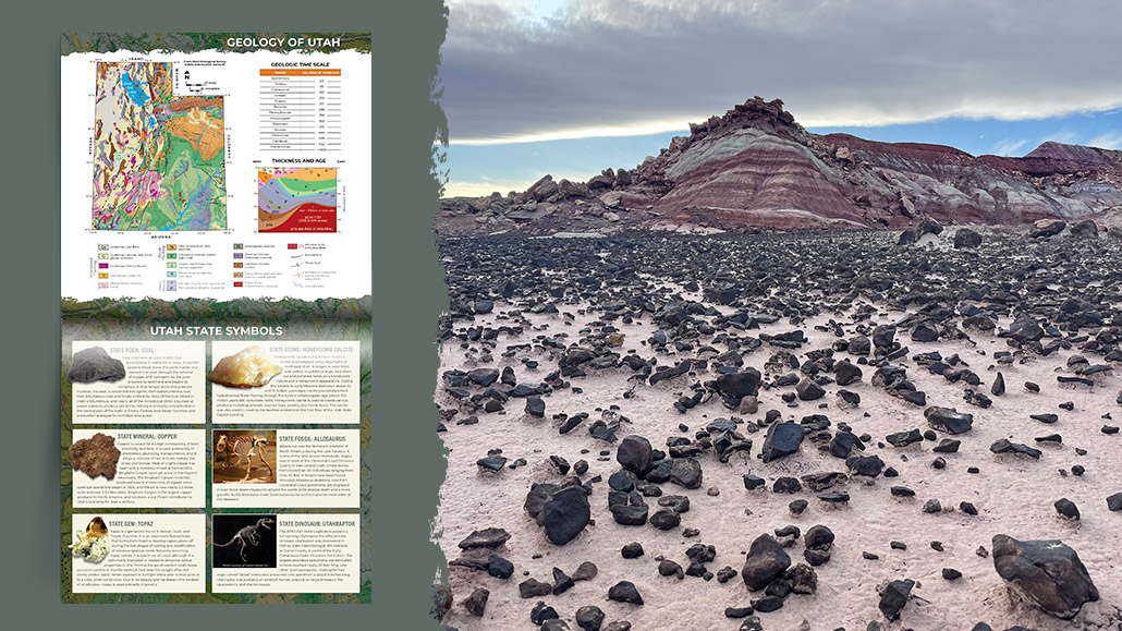
Moore Cutoff Road, Emery County Photographer: Rachel Willmore The dark-gray to black limestone nodules that litter the ground have weathered out of the purple and gray-colored Brushy Basin Member of the Jurassic-age Morrison Formation. The siltstone, claystone, mudstone, and limestone beds of the unit were deposited around 150 million years ago in lakes, rivers, and floodplains.
The 2026 Calendar of Utah Geology is available now for $8.95. Calendars can be purchased online at www.utahmapstore.com and at the Natural Resources Map & Bookstore located at 1594 West North Temple in Salt Lake City.
The Utah Geological Survey (UGS) provides timely scientific information about Utah’s geologic environment, resources, and hazards. As a division of the Utah Department of Natural Resources, the UGS serves the citizens and government of Utah by conducting unbiased, applied scientific research and providing data and expertise to help guide decisions related to the state’s geologic resources and hazards.