GeoSights: San Juan River Rincon, San Juan County
by Marshall Robinson


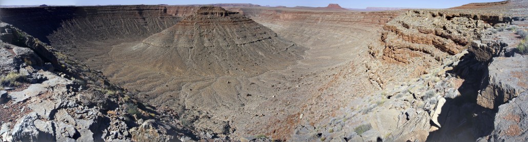
Rincon is a term used in the southwestern U.S. to describe a dry, semicircular canyon with a butte in the middle. It is the remnant of an entrenched cutoff river meander. Rincons are found along a few rivers across the Colorado Plateau; some are very prominent, while others are not. Many rincons in Utah are inaccessible by car and may only be seen via air, boat, or very long hike. Of those that are accessible by car, an even smaller portion are easily accessed by car. One rincon on the San Juan River in southwestern Utah between Bluff and Mexican Hat fits the bill. This unnamed rincon is worth visiting as you can drive to its edge. The San Juan River rincon is approximately 1 mile in diameter at its widest, over 600 feet deep, and the butte in the middle of the rincon towers over 550 feet above the surrounding ancestral river bed.
Entrenched river meanders occur when low velocity meandering streams later increase velocity (due to uplifted headwaters) and downcutting power, causing the channel pattern to become “entrenched” in the underlying bedrock over millions of years of erosion (for additional information on the geologic processes that create entrenched river meanders see Survey Notes v. 45, no. 3, p. 12). River meanders, entrenched or not, can eventually become abandoned or cutoff due to the erosive power of rushing water along the outer banks of the entering and exiting meander corners. The river channel corners move ever-so-slowly toward each other, until the neck of land separating the channel bends finally erodes away completely, leaving behind an oxbow lake that is no longer connected to the main river channel. In the case of entrenched cutoff river meanders, oxbow lakes rarely (if ever) stick around for very long as the main river channel’s erosive power washes away the sediment at the ends of the lake causing the lake’s water to flow back into the main river channel. The lack of water in the rincon could also have something to do with the fact that entrenched cutoff river meanders are generally only present in desert environments.
At the San Juan River rincon, the Halgaito Formation overlies the Honaker Trail and Paradox Formations. These roughly 300-million-year-old rock formations consist of limestone, siltstone, sandstone, and shale. Deposition of these rocks occurred at a time when the dominant landscape was marine and the sea level fluctuated widely. After the sea receded, a mostly flat terrain was left behind for the ancestral San Juan River to slowly meander across before uplift of the Colorado Plateau occurred during the past few tens of millions of years. This uplift caused the meandering stream to begin downcutting, entrenching itself over 1,000 feet below its original elevation. The present-day rincon was part of the original river path, but at some point, the San Juan River cut a straighter path, abandoning the now-dry canyon.
How to Get There

From Moab, drive south on U.S. Highway 191 for approximately 100 miles to Bluff. About 6 miles west of Bluff where U.S. Highway 191 turns south, continue west on U.S. Highway 163 for approximately 7.25 more miles. Turn left onto County Road 2351 (dirt road), then continue for approximately 4.5 miles where you can pull off the road and walk to the edge of the rincon. Do not continue past this point in a sedan as the road becomes very rough. According to Google Maps, County Road 2351 creates a loop with U.S. Highway 163. This may have been true at some point but is no longer the case. The overlook’s coordinates are 37.2238° N, 109.7343° W.
Survey Notes, v. 50 no. 3, September 2018